All Activity
- Past hour
-
We knew last week was the warmest temperatures until Memorial Day.
-
Models were picking up on the precip lull earlier today. Watch a regional radar and you will see that things are starting to fill in. From MKX: As precip continues to shift east, attention will turn westward toward the precip responsible for phase three of the event. Due to a lack of deeper lift & some lingering dry air aloft, a precip lull continues in locations west of a Monroe-Madison-Fond du Lac line. Anticipate that this lull will continue through mid-evening (~8 PM), prior to filling in as an upper wave & affiliated deformation zone move in during the mid-evening hours. Still anticipate the development of moderate to heavy snow along the deformation band, with enhanced rates continuing into the early morning hours Monday. Will continue to monitor observational & model trends through mid-evening and provide additional updates as necessary.
-


-
 Yea that makes no sense. I don't understand these early dismissals.
 -

Occasional Thoughts on Climate Change
WolfStock1 replied to donsutherland1's topic in Climate Change
Making a blanket statement like that shows how how much you've been influenced by the propaganda machine, and generally ill-informed. In general no - renewables are not cheaper in most circumstances, when all factors are considered (inclusion of additional baseline power sources for when the wind and sun don't cooperate, additional transmission infrastructure, higher land use, etc.). They can be cheaper only in specific circumstances when the stars align; they are not cheaper in a broad-use infrastructure sense. If they were cheaper, then power companies wouldn't need the much-higher-level of subsidies to incentivize their use. -
 Stafford and Spotsylvania closed - but are doing asynchronous learning online
 -
 I think you’ll get classes after 2pm canceled. Though UVA actually has designated storm shelters on-Grounds so maybe they’ll be a little more willing to give it a go. I recall a tornado threat day where I was in class watching the radar so they obviously didn’t cancel that day!
- 162 replies
-
- 1
-

-
- severe
- thunderstorms
- (and 1 more)
-
 yeah i'm going to take our car and move it into a nearby parking garage tomorrow morning.
- 162 replies
-
- 1
-
-
- severe
- thunderstorms
- (and 1 more)
-
Raw chilly day. Prospects for any sustained mild weather look slim for the next couple of weeks.
-
 This. Liability.
 -
 Wonder if UVA will cancel classes or send out an email. I know back when you went they rarely canceled but now for even 2 inch snowstorms they move stuff online.
 -
Don’t see this very often
-
Through first half of the month: 2 SVR Watch, 1 TOR Watch, 1 SVR Warning, 1 TOR Warning & 2 High Wind Warnings. Suppose an alleged cherry on top would be some winter headline, but I’m done with snow tbh. Am entertained.
-
I dont recall such a lack of precip now shown on models regardless of who got how much now. I think you cant point out one observation place and defend anything. Again just trying to learn as I look at the radar and wonder why this fell apart with lack of precip in WI/MI in certain areas.
-
They just want the liability off their hands. Once one district called it off everyone was gonna follow. I’m even fairly sure OPM will send me home early if the advice going around is “be off the roads by 4.” Unlikely this tops derecho but there is a bigger tornado threat.
-
This is on their page Important Message: 3/15/2026 at 6:40 PM -- Refresh page to update message UPDATE: CODE BLUE – The Weather Forecast Is Getting More Serious! EARLY DISMISSAL for Monday, March 16 The National Weather Service is expressing increasing concern about the probability of severe weather on Monday. This is projected to be more significant than originally thought. Our area should be prepared for significant thunderstorms, high winds, hail and the potential for damaging tornadoes. The timing of the most severe weather is projected to coincide with our normal school dismissal schedule, bus routes across the county and the start of many after-school activities, including athletics and practices.
- 162 replies
-
- 1
-
-
- severe
- thunderstorms
- (and 1 more)
-
 The school thing is blowing my mind.. I have no idea what to anticipate here.. Is this going to be like the derecho? Or something more extended in time?
 -

Central PA Spring 2026 Discussion/Obs Thread
Voyager replied to Voyager's topic in Upstate New York/Pennsylvania
I was just reading the mid Atlantic forum, and many school districts are closing early tomorrow in anticipation of the severe storms. -
Montgomery County public schools just declared early dismissal
- 162 replies
-
- 1
-
-
- severe
- thunderstorms
- (and 1 more)
-
 lol I just woke up from a nap. Feeling kinda under the weather right now. last year I didn’t do any severe weather at all but I made a promise to myself to try and learn about it this year, so you likely see me a lot more active
 -

2026-2027 El Nino
Stormchaserchuck1 replied to Stormchaserchuck1's topic in Weather Forecasting and Discussion
2009 -1.3 1986 -0.3 If you're going to include those, you should include 1957: -2.7 So we've never in developing Moderate+ El Nino's since 1950 had a March SOI over +2.1 Now it has recently reversed from positive, to negative (-9) on March 15th. -
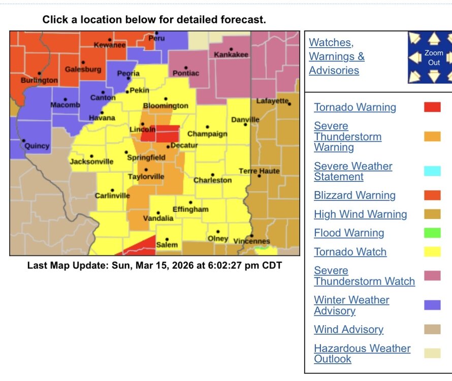
The NWS warning/watch map is a kaleidoscope of colors in the mid-west. It's not often we see a map that goes from blizzard warning to tornado warning in less than 70 miles. Current view of the gradient between Lincoln and Galesburg IL is impressive. The zoomed in view centered on Lincoln shows nearly every color in the NWS arsenal.
-
0.46" rain so far with the 1st part of the system.
-
The big school district dominoes have started to fall... Fairfax just declared 3 hour early dismissal Prince William two hour early dismissal Faquier County early dismissal Nothing yet from Loudoun but that should be coming soon
-
Don’t they already have 20”? And part 2 hadn’t started
.thumb.png.4150b06c63a21f61052e47a612bf1818.png)


.thumb.png.e28622a101ead8a503efd5015c7d3862.png)


