All Activity
- Past hour
-
I am in there! And solution man. And yes I am watching that.
-

2/22-23 "There's no way..." Storm Part 2
SomeguyfromTakomaPark replied to Maestrobjwa's topic in Mid Atlantic
I wouldn’t be shocked with 8 or more, very dynamic situation and some of these mesos are throwing us bands through Monday morning. Tuck this a tiny bit more and boom. -
we have a professional weather met craig allen doing the weekend weather on wcbs 2.
-
Start time down in Ocean City NJ? 10am?
-

“Cory’s in NYC! Let’s HECS!” Feb. 22-24 Disco
ORH_wxman replied to TheSnowman's topic in New England
Anyone SE of an ASH-HFD axis doesn’t have much to worry about unless youre being greedy and demand 2 feet. -
I am tbh. This is such a dynamic setup and the fact we have all the hi-res and regionals adjusting west should give merit. Plus, EC at the eastern envelope of its own ensemble members is a red flag. These solutions with the wrap snow for hours after the meat of the storm is gone is actually classic for these large Atlantic cyclones that occlude. Makes sense the hi-res are showing these solutions.
-
lol you weenies are a trip
-

Richmond Metro/Hampton Roads Area Discussion
jlewis1111 replied to RIC Airport's topic in Mid Atlantic
anyone have the 18z gfs snow map thanks -
my point and click!!!! holy.... Sunday Snow, possibly mixed with rain, becoming all snow after 3pm. High near 37. Breezy, with an east wind 15 to 20 mph. Chance of precipitation is 80%. New snow accumulation of 1 to 3 inches possible. Sunday Night Snow. The snow could be heavy at times. Low around 31. Windy, with a north wind 20 to 30 mph, with gusts as high as 45 mph. Chance of precipitation is 100%. New snow accumulation of 12 to 18 inches possible. Monday Snow, mainly before 1pm. The snow could be heavy at times. Areas of blowing snow between 9am and noon. High near 35. Windy, with a northwest wind 25 to 30 mph decreasing to 20 to 25 mph in the afternoon. Winds could gust as high as 45 mph. Chance of precipitation is 80%. New snow accumulation of 3 to 7 inches possible.
-
Latest forecast for my yard is 9-13 late tomorrow/tomorrow night, and 1-3 on Monday. Just a tad less for Easton. Hoping to get home late Monday afternoon. Roads should be decent by then.
-
Wow. Love to see UKMET on board. Going out for the night and hoping I don’t come back to any major swings lol
-

“Cory’s in NYC! Let’s HECS!” Feb. 22-24 Disco
Damage In Tolland replied to TheSnowman's topic in New England
Absolutely -
This gradient scares the shit out of me
-
“Cory’s in NYC! Let’s HECS!” Feb. 22-24 Disco
Damage In Tolland replied to TheSnowman's topic in New England
Donny Baseball! -
2/22-23 "There's no way..." Storm Part 2
Grothar of Herndon replied to Maestrobjwa's topic in Mid Atlantic
Keeping hope alive! -
How accurate is the HDRPS??
-
I wouldn’t. City will probably look the same for a week with how heavy the snow is anyways.
-

“Cory’s in NYC! Let’s HECS!” Feb. 22-24 Disco
weatherwiz replied to TheSnowman's topic in New England
I wouldn't be surprised if the GFS was actually a bit too low with QPF, especially along the QPF gradient (like Ray alluded too earlier) but too me it seems the GFS is way too quick in shutting down the CCB. I know the system has occluded but its shutting things down a bit too quickly with 850mb winds coming in at 50-60+ knots. Yeah its more of a northerly component but there is still a moisture fetch from the Atlantic. -

Richmond Metro/Hampton Roads Area Discussion
wasnow215 replied to RIC Airport's topic in Mid Atlantic
Except for the fact they said it could be much more lol... just like we can't say that it will be more we can't say that it's not a possibility -

“Cory’s in NYC! Let’s HECS!” Feb. 22-24 Disco
metagraphica replied to TheSnowman's topic in New England
You know how goes with these. People panicking at every little wobble in the models. Some of us know to hold the course. We’re all getting buried!! -
I saw one in the NYC forum.
-
Ukie caved more
-
Wheres Lonnie Quinn these days? hes gotta be all jacked up with his sleeves rolled up somewhere!
-

“Cory’s in NYC! Let’s HECS!” Feb. 22-24 Disco
donsutherland1 replied to TheSnowman's topic in New England
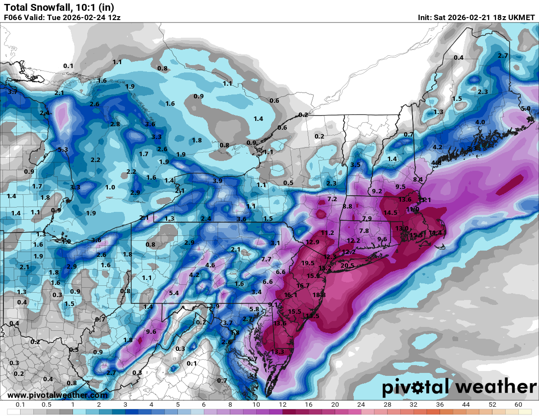
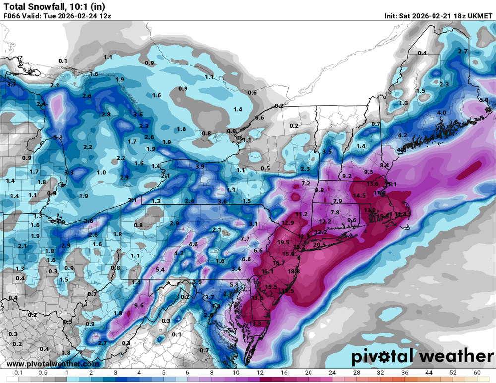
The 21z NBM v.5.0: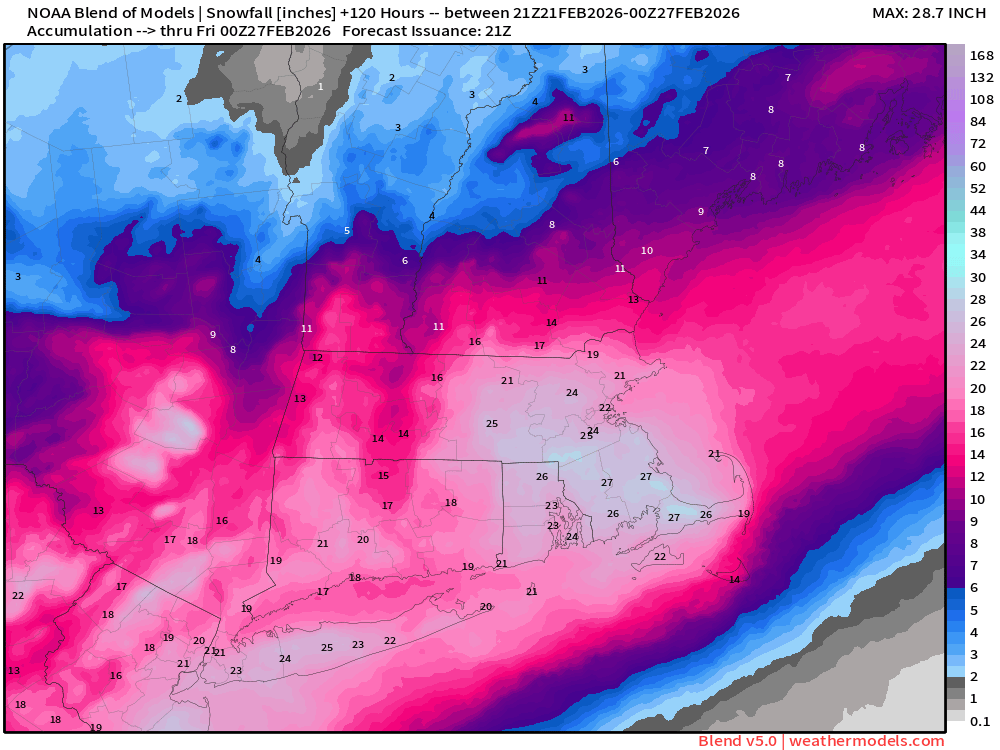
-
Imo, speaking as your geographic neighbor, no. Basically none of the guidance has DC consistently booming or jackpotting in any way. 2-4" bar for success, 6"+ would be great. 8" or more? I'd be shocked