All Activity
- Past hour
-
88 for my high after a low of 47 stunning weather with deep blue skies golden sunshine and low dews...in the words of Mr G...Kaity if you want to take off the next two days to play hooky at the beach Monday and Tuesday will be more of the same maybe a tad cooler go ahead and do it
-
Was beautiful yesterday, but my son had a 9am start for his travel baseball game. So didn’t have to deal with the warmth off the turf field that occurs. Had that last Sunday with the 3pm start.
-
yeah 66 with a wind and clouds...so enjoyable and guess what you get your fall weather in april and may when the weather is awful here
-
Yea that map is not impressive. A bit below average in general for most. Though if the city gets 25 inches compared to the last few years it will feel huge.
-

Spooky Season (October Disco Thread)
Torch Tiger replied to Prismshine Productions's topic in New England
Legit early-summer type airmass out there. May/June type deal -
Brutal Philly sports weekend. Don’t even have interesting weather to discuss
-
Based on that, another below average season IMBY.
-
85 for a high at home, glad I’m not there. Yes, it’s 90 here in Grapevine but that doesn’t bother me as much as the hot temps at home would. Gotta head back tomorrow but at least fall temps arrive on Wednesday.
-
If I wanted year long summer I'd be in Florida
-
What a wasted failed season
-
Signal for some sort of hybrid or subtropical system off the coast near mid month.
-
Starks kinda looking like a bust, but with such a bad defensive "scheme", don't want to be too quick to pass judgment. Whatever the reasons, this dude has been absolutely awful to this point.
-

Spooky Season (October Disco Thread)
CoastalWx replied to Prismshine Productions's topic in New England
Love how warm seasons keep expanding. ACATT will have two days to enjoy before it warms again. -
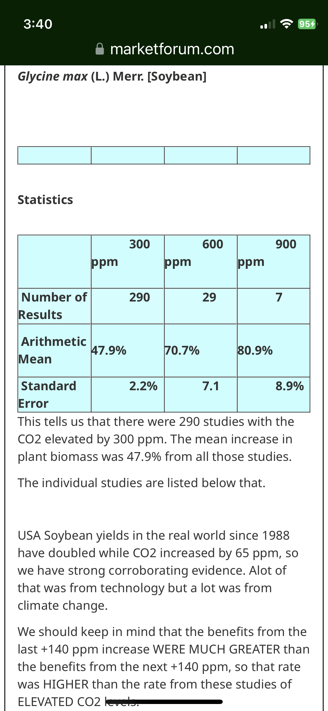
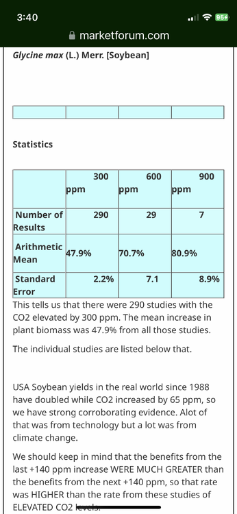
Hey Charley, As promised with the help of a Midwest pro met., here is the first response supporting the net benefit of CC to crops. This one covers soybeans (posts to cover other crops to come later): Let's separate out other factors(technology for instance), so that we can look only at the photosynthetic benefits from increasing CO2 to soybeans. Turns out that the impact of CO2 on soybeans has more studies than almost any other plant. Here's how to access the empirical evidence/data from the site that has more of it than any other. Please go to this link: http://www.co2science.org/data/data.php Go to plant growth data base: http://www.co2science.org/data/plant_growth/plantgrowth.php Go to plant dry weight(biomass): http://www.co2science.org/data/plant_growth/dry/dry_subject.php Pick the name of a plant, any plant and go to it based on its starting letter. Let's pick soybeans. Go to the letter S: http://www.co2science.org/data/plant_growth/dry/dry_subject_s.php Then scroll down and hit soybeans. This is what you get: http://www.co2science.org/data/plant_growth/dry/g/glycinem.php Look at the following screenshot for the table showing the large benefits of CO2 to soybeans:
-
Maybe one of the top beach days of the summer. Water is very warm. Air about the same. Well past any early/mid season Ambrose jet stuff. Plus everyone is probably sweating to death at a pumpkin patch so it’s very empty.
-
.thumb.jpg.6a4895b2a43f87359e4e7d04a6fa0d14.jpg)
Central PA Fall Discussions and Obs
Yardstickgozinya replied to ChescoWx's topic in Upstate New York/Pennsylvania
Most plants are aborting at this point because of low moisture in the rhizospher. You need a shorter day than where we're at at this point to trigger etiolation in most plants and trees. However, auxins and other hormones are tied to photo period length and temperature. If the cooler temperatures don't cause abscission, first the shorter photo period eventually will. - Today
-
The highest rainfall in the region was 3.74" at Stansbury Park which is near the southern end of Great Salt Lake about halfway from downtown SLC to Tooele. At the Nevada border, 100 miles west, rainfalls were only about 0.05" -- also much less rain fell in northern portions of the Wasatch Front around Tremonton (0.4") ... so this rainfall event was centered over the SLC to Lehi portion of the region between Great Salt Lake and Lake Utah. News reports show snowfall pictures at ski resorts above 7,000 feet.
-
got a feeling this'll be similar to last winter in the way that we had no idea what was coming for us... not saying it'll snow 50 inches or even 20 for that matter but it'll be a regression towards the mean after snow droughts we've been having
-
SLC had 2.47" of rain on Saturday, easily breaking the daily record of 0.74" (1882). Some flooding problems were reported in the Salt Lake City and Tooele regions. official report ... their 2.43" value is only to 8 p.m. ... seems to be the new October record as it is second all-time 24h rainfall and record 2.64" set May 3, 1901. RECORD EVENT REPORTNATIONAL WEATHER SERVICE SALT LAKE CITY UT823 PM MDT SAT OCT 04 2025...RECORD DAILY MAXIMUM RAINFALL SET AT SALT LAKE CITY UT...AS OF 800 PM MDT A RECORD RAINFALL OF 2.43 INCHES WAS SET AT SALT LAKE CITY UT. THIS BREAKS THE OLD RECORD OF 0.74 INCHES SET IN 1882.THE DAILY TOTAL OF 2.43 IS THE SECOND HIGHEST DAILY PRECIPITATION ON RECORD FOR SALT LAKE CITY UT (2.64 SET ON MAY 3 1901). THE TWO DAY TOTAL OF 2.57 INCHES IS THE FIFTH HIGHEST 2 DAY TOTAL ON RECORD FOR SALT LAKE CITY UT (3.55 INCHES SET ON MAY 3-4TH 1901).
-

Spooky Season (October Disco Thread)
powderfreak replied to Prismshine Productions's topic in New England
MVL just popped 86F on the hourly too up here. Its a torch. -
Teb reporting 89
-
Some of us enjoy all four seasons.
-
Could be an anomaly but hit 90 degrees at my house. Sun is dam strong today too. Just low enough in horizon that it gets under my visors.
-
Fucking hot on the baseball/football fields today
-
82 the high here