All Activity
- Past hour
-
That was the definition of a sprinkle.
-
Sun was out for the last hour, and we are at 71. Clouding back up now…but at least we very mild.
-
Who the hell would want that now? It won’t happen like that being 11 days away, but you could have that crap.
-
59° overcast Could be worse
-
-
66
-
That aluminum truck body crunching like a pretzel. Yikes. That's why we steel.
-
Getting pretty close to my sweet spot of temps and humidity. Really nice out right now with a few breaks in the clouds.
-
That Detroit area guy will be disappointed. This setup is giving nighttime QLCS for his area... Tornado thread definitely looks legit back towards WI / IL / IA though...
-
Up to 68 with rain incoming.
-
mild active spring taking away the sting of the dull back end of winter
-
best climo?
-

E PA/NJ/DE Spring 2026 Obs/Discussion
Birds~69 replied to PhiEaglesfan712's topic in Philadelphia Region
76F/DP 60F Cloudy...if the sun pops out, 80F+ with ease. -
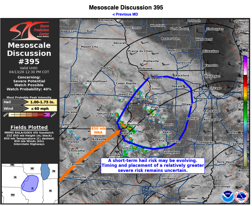
Bit of an appetizer ahead of likely busy next few days Mesoscale Discussion 0395 NWS Storm Prediction Center Norman OK 1103 AM CDT Mon Apr 13 2026 Areas affected...portions of extreme eastern Iowa into western...central...and northern Illinois Concerning...Severe potential...Watch possible Valid 131603Z - 131730Z Probability of Watch Issuance...40 percent SUMMARY...Some hail (possibly over 1 inch in diameter) may occur with gradually intensifying storms over the next few hours. It is unclear if these storms will pose the greatest severe risk this afternoon, or if the greater risk will occur with later storms. DISCUSSION...850 mb troughing is underway across the Plains states into the Midwest, with 15Z mesoanalysis showing the northeasterly terminus of a LLJ currently positioned along the IA/IL/MO border. Here, an 850 mb Td gradient exists, with modest WAA likely supporting the gradual intensification of elevated convection within this regime. The 12Z ILX observed sounding and 15Z mesoanalysis depicts 700-500 mb lapse rates in the 8-8.5 C/km range, contributing to MUCAPE approaching 2000 J/kg. These storms are encroaching on a region of stronger 500 mb southwesterly flow, driven by a departing upper trough over the eastern U.S., which is resulting in 30-40 kt of effective bulk shear ahead of the storms. If storms continue to intensify, it is plausible that at a hail threat may materialize over the next few hours, with some stones potentially exceeding 1 inch in diameter. Short-range high resolution ensemble guidance is providing mixed signals regarding the evolution of this convection. Some deterministic CAMS show that the ongoing storms eventually consolidate and develop into stronger supercell structures in northern IL by afternoon. Other guidance members depict the ongoing storms oscillating in intensity, while stronger storms develop later. As such, there is an appreciable degree of uncertainty as to the evolution of the longer term severe threat with these WAA storms. All this being said, convective trends will continue to be monitored for the need of a WW issuance. ..Squitieri/Guyer.. 04/13/2026 ...Please see www.spc.noaa.gov for graphic product... ATTN...WFO...LOT...ILX...LSX...DVN... LAT...LON 40829153 41349115 41809076 42269021 42318942 42178872 41918839 41478835 41028850 40608866 40238895 40058932 39988999 40039043 40249121 40829153 MOST PROBABLE PEAK WIND GUST...UP TO 60 MPH MOST PROBABLE PEAK HAIL SIZE...1.00-1.75 IN
-
off to the races-70 here
- Today
-
70 here now-partly sunny winds kicking up a bit
-
went ahead and started a thread
-
figured it's probably due, almost a lock that someone in the sub's gonna see some action today or tomorrow. primarily hail/tornado risk.
-
Sun breaking out…67. GWLH.
-
58 here with the south wind. So much for 70s .
-
Pavement in Greenbelt approaching “fully wet”
-
sun out now. see lots of blue
-
Sun breaking through. 60.
-
After Saturday being absolutely perfect, yesterday was warm but once again crazy windy. I recorded a 65MPH gust yesterday afternoon and spent about 5 hours straights with winds gusting over 40MPH on a consistent basis.
-
In / out of the clouds


.thumb.jpg.ad3a2e31d30aff035044689b311a0540.jpg)


