All Activity
- Past hour
-

E PA/NJ/DE Summer 2025 Obs/Discussion
BBasile replied to Hurricane Agnes's topic in Philadelphia Region
At least there is something to watch during this stretch of nothingness.
-

E PA/NJ/DE Summer 2025 Obs/Discussion
ChescoWx replied to Hurricane Agnes's topic in Philadelphia Region
A beautiful weekend is underway! After a chilly start with many spots well down into the 50's with the lowest at our typical chilliest station at the Warwick DEOS with a low at 51.1 degrees. Both today and tomorrow will continue our run of below normal average temperatures but with high temperatures getting close to normal both days. We finally get back to normal August levels by Monday and continue warming with some low spots touching 90 degrees by Wednesday. We stay dry through Wednesday, but shower chances begin to creep up by that night and through the end of the week.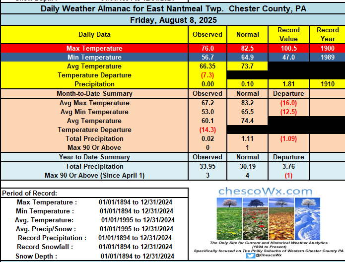
-
 74 / 57 and another sensational summer day for bbq, beach, pool, outsoors. Low - mid 80s sunny and dry. Warmer Sunday, for some to 90 / low 90s and the start of the heatwave. Strong heat focusses more inland and west but most to low 90s through Friday. Peak heat (95+) Tue-Wed, in the hottest spots, perhaps upper 90s. Nest shot at any rain Wed Pm storms. Overall warm - hot / humid and wet with tropical activity. Ridging into the northeast with Atlantic ridge flexing nearby. 8/9 : Warm/dry amazing 8/10 - 8/15 : Hot / Humid - Strongest heat Tue/Wed. Hotter inland and west. Some storms possible Wed PM 8/15 - Beyond : Overall warm - hot / humid , Wet. Tropical activity in the 8/20 ish
 -
close to what? not SNE

-
Probably heading ENE by then, so eastern SNE gets 60s gusts and a pile of rain while August stays dry here. Had some rumbles about 6 last evening from a TS a few miles north. A bigger system seemed aimed right at us, but it only reached West Farmington, where it died. August precip still 0.00", only 0.13" in the past 19 days and the current forecast has nothing thru Friday (though the AFD mentioned some possible TS midweek).
-
What a great sunrise. 57/ 56 earlier this morning.
-
Its close
-

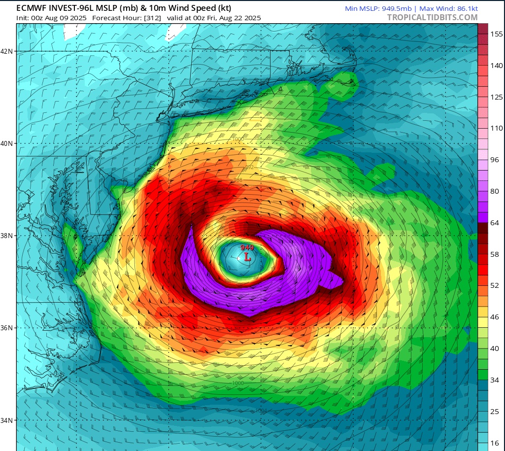
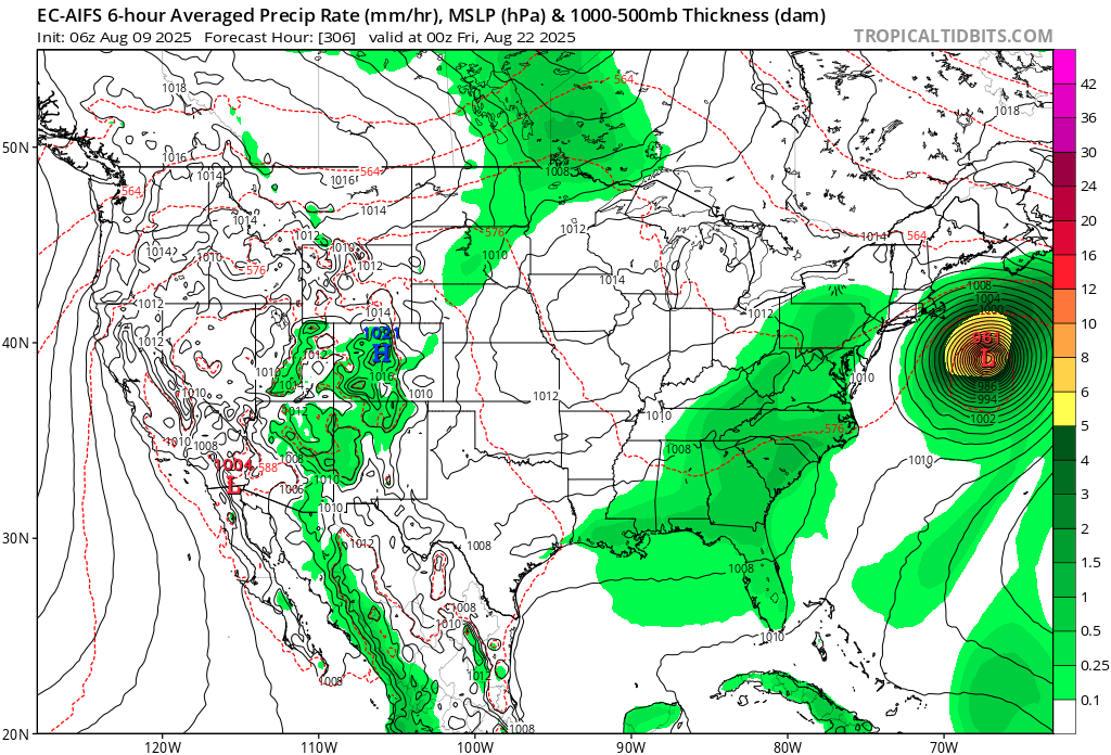
Eastern Tropical Atlantic Wave - 0/40
BarryStantonGBP replied to BarryStantonGBP's topic in Tropical Headquarters
OI LAD WE HAVE A MAGALUF LAD NOW 0/40 AND ORANGE IT’S COMING HOME A tropical wave that has now emerged offshore the west coast of Africa is producing a large area of disorganized showers and thunderstorms. Environmental conditions appear favorable for gradual development of this system, and a tropical depression could form by the middle to latter portion of next week while it moves west-northwestward at 15 to 20 mph across the eastern and central tropical Atlantic. Locally heavy rainfall is possible Sunday and Monday across portions of the Cabo Verde Islands. * Formation chance through 48 hours...low...near 0 percent. * Formation chance through 7 days...medium...40 percent. -
The tenor of eps is fish. No way around it
-
Good call 12 days out..
-
Agreed… MDT is running -3.9 below normal temperature this month to date.
-
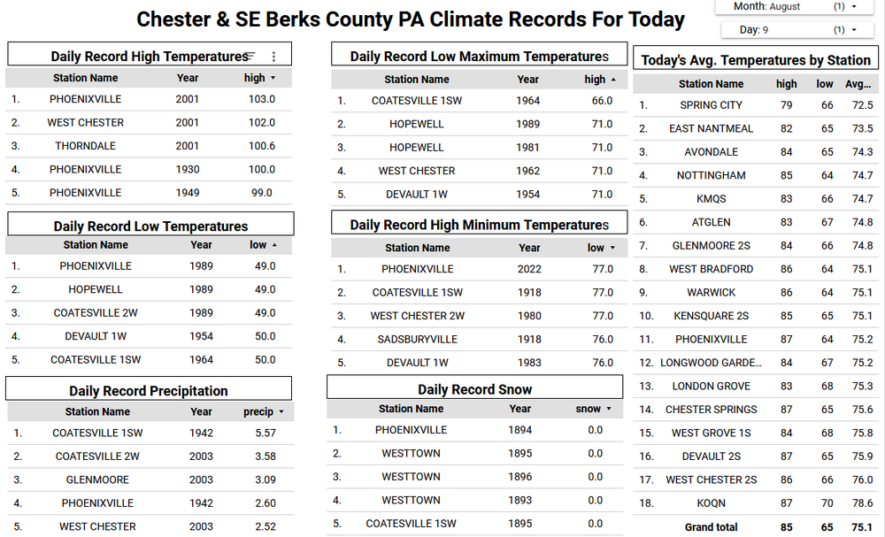
 53 in Muttontown & 54 in Syosset this morning.
 -
As a wise Wolfie has said many times.. things can change , no one knows , maybe it will maybe it won’t , we track
-
Lots of anomalous ridiging in the forecast around D10.... but that of course could favor FL just as much as New England. I'm sure it'll whiff.

-
Would that throw 60 mph gusts west ? Let’s get this up the CTRV
-
Persistent easterlies being modeled over the tropical Pacific this month….I think next month’s long range model updates are going to move further towards a La Niña event for this coming fall/winter…..
-
No doubt.
-
By the look of the pattern there’s probably a better shot of the Pats going 17-0 than a direct hit. Probably can’t even rule out a track that is into FL or SE coast depending on exactly if/where a center pops
-
That will be 300mi out to sea by Monday's Euro runs.
-

Eastern Tropical Atlantic Wave - 0/40
GaWx replied to BarryStantonGBP's topic in Tropical Headquarters
The 6Z GEFS is similar to prior runs. Though it’s still very early, the overall consensus in the last few runs of models/ensembles seems to me to be suggesting a better chance of a safe recurve from the Conus vs a hit with the Gulf having an even lower threat than the E coast. The faster the development in the E ATL, the lower the US hit chance I believe, especially with a relatively high latitude MDR track progged by the models. If OTOH development is slow the next few days, that could portend at least a higher E coast hit chance. -
Yeah, I think we should begin evacuations now. Ecacuate where? Who cares?! Just evaciate!
-
Op way west of ens. Its fishing
-
41° at MVY this morning

- Today
-
 Another 50's August morning.


.thumb.png.4150b06c63a21f61052e47a612bf1818.png)


