All Activity
- Past hour
-

The “I bring the mojo” Jan 30-Feb 1 potential winter storm
KrummWx replied to lilj4425's topic in Southeastern States
12z euro doesnt look bad at all through 63 -

Possible coastal storm centered on Feb 1 2026.
amarshall replied to Typhoon Tip's topic in New England
The nap is fantastic -
The “I bring the mojo” Jan 30-Feb 1 potential winter storm
UpstateSCBud replied to lilj4425's topic in Southeastern States
Are the 12z runs the first with the recon data fully included? -
-
Chances for a major winter storm on the southside seem to be diminishing. For us to see a good storm we need it to travel NE along the coast so we can have that banding set up over top us. With out that, we will be battling dry air that is being pumped in from the high. UKMET shows a possible solution. I can’t remember the year, maybe 07-09 we had similar ULLs moving to the south of us and models and local Mets were calling for 4-6 inches or 4-8 inches for the southside a day before the event. There may have been two storms rather close to each other. One got some flurries in to the southside and the other one was partly cloudy here. Both cases NE and eastern NC received measurable snow. The lows basically were kicked east out to sea allowing dry air to win. Rooting for the low to develop just off the coast and move NE so we can score. Hate to waste the cold and not get a good one. We’ll see what happens the rest of the day as the new runs come in.
-

2025-2026 Fall/Winter Mountain Thread
Sw NC weather replied to Buckethead's topic in Southeastern States
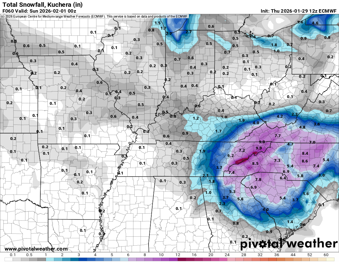
Euro AIFS is a good 5-10” snow for WNC. Regular Euro is similar a smidge east from last run but not bad. -
Courtesy of Bouncycorn. This is a 10:1 so multiply by 1.5 to 2.
-

Possible coastal storm centered on Feb 1 2026.
Damage In Tolland replied to Typhoon Tip's topic in New England
Is Tim right ? Or cocked? https://x.com/surfskiweather/status/2016913994129240283?s=46&t=dhcbvkjmRcyBVQtDxJ3lRg -

- 319 replies
-
- 1
-

-
- extreme cold
- snow
- (and 1 more)
-

The “I bring the mojo” Jan 30-Feb 1 potential winter storm
NorthHillsWx replied to lilj4425's topic in Southeastern States
Pain. Thankfully Euro AI looks much better -

Possible coastal storm centered on Feb 1 2026.
40/70 Benchmark replied to Typhoon Tip's topic in New England
I'm getting my first colonoscopy Monday (true story)....it won't be very pleasurable, but I'll be fascinated by tracking every twist and turn of the scope on it's journey! -

February 2026 Medium/ Long Range Discussion: Buckle Up!
Stormchaserchuck1 replied to Weather Will's topic in Mid Atlantic
Looks like it. We were colder than average last Dec - Feb too, even though I don't know if all 3 months were below average. -

Possible coastal storm centered on Feb 1 2026.
Wxbear25 replied to Typhoon Tip's topic in New England
So? Discussing modeling, forecasting, weather in general shouldn't be looked down upon just because you're not getting snow, particularly when it pertains directly to the system the thread is about. I get being frustrated by the overwhelmingly likely outcome of the storm, I just don't think its right or fair to talk down to or mock people who are in good faith actively discussing aspects of the modeling/atmosphere directly pertaining to its evolution/modeling, etc. If thats not how you meant it to come across, I apologize, but as someone who has been doing directly what you were lamenting, thats the way it seemed -

The “I bring the mojo” Jan 30-Feb 1 potential winter storm
eyewall replied to lilj4425's topic in Southeastern States
-
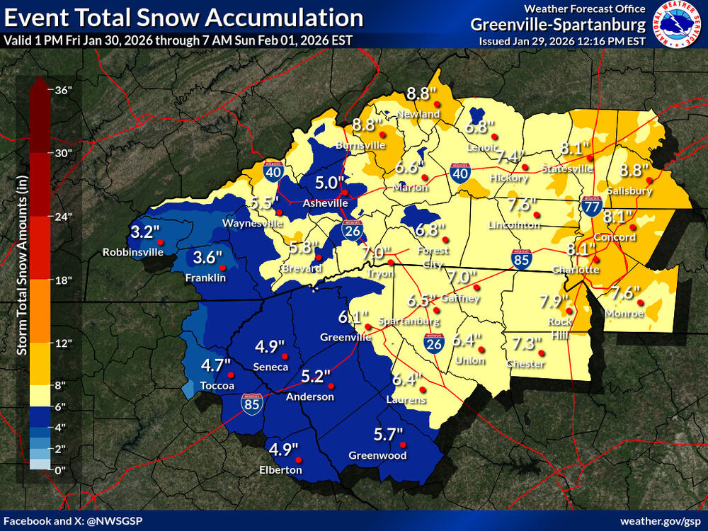
Big increase from GSP:
-
February 2026 Medium/ Long Range Discussion: Buckle Up!
Stormchaserchuck1 replied to Weather Will's topic in Mid Atlantic
585dm in Salt Lake City in the dead middle of Winter! Quite a Winter they are having out there in the Rockies and West coast, for a much of the area it's the #1 warmest Winter on record to date (since Dec 1). Makes me nervous about a Stronger El Nino next year. -

The “I bring the mojo” Jan 30-Feb 1 potential winter storm
Snowncanes replied to lilj4425's topic in Southeastern States
Euro a decent tick west at H5 hr42. Heights a little flatter over NE -

February 2026 Medium/ Long Range Discussion: Buckle Up!
JenkinsJinkies replied to Weather Will's topic in Mid Atlantic
Looks like we've got a shot at all 3 met winter months having below average temps? -

Possible coastal storm centered on Feb 1 2026.
WinterWolf replied to Typhoon Tip's topic in New England
So far it hasn’t…looks to have staying power this go around. -
EURO holding steady so far. Images to follow!
-
- 319 replies
-
- 1
-

-
- extreme cold
- snow
- (and 1 more)
-

Winter 2025-26 Medium/Long Range Discussion
A-L-E-K replied to michsnowfreak's topic in Lakes/Ohio Valley
winter mode set to on for that run gfs run either way, def no signs of winter losing grip over the eastern us any time soon and probably for the best, don't want all this cold staying bottled up and pissing all over our april -
If we use 100:1 ratios we have a decent snowstorm
-
5.3 degrees for the low today Currently 18.3 degrees
-
Possible coastal storm centered on Feb 1 2026.
WinterWolf replied to Typhoon Tip's topic in New England
This would have been the 3rd Sunday in a row with snowstorms had it panned out. And just as a reminder..two weeks ago, that Sunday deal was a gonner until 0z Saturday morning(overnight Friday into Saturday), when modeling all jumped on board for a hit, rather than a miss. Now, I think this is toast too…and certainly not saying this is gonna happen here, but it did two weeks ago. So those of you hanging on Until Friday night overnight is very reasonable.