All Activity
- Past hour
-
one of my favorite summers of all time....13 and what an incredible year and music and days and days of watching mtv and then going outside doing what 13 years old do and coming in at night with air conditioning downstairs to watch endless amounts of music videos
-
Manhattan radiates really well, I am not surprised you dipped into chilly temps.
-
I do....belle mead in da house
-
.thumb.jpg.6a4895b2a43f87359e4e7d04a6fa0d14.jpg)
Central PA Spring 2025
Yardstickgozinya replied to canderson's topic in Upstate New York/Pennsylvania
We are only marginal in terms of risk today but here's is spc take on today. ...Central Appalachians and Mid-Atlantic... Recent surface observations reveal a residual front/marine boundary draped from eastern VA into the eastern Carolinas. East of this boundary, richer low-level moisture in the form of low to mid-60s dewpoints is noted extending northward into southeast PA. Aloft, an embedded shortwave orbiting around the primary upper low is noted over the mid-MS River Valley in recent water-vapor imagery. This feature is expected to pivot into the Mid-Atlantic and central Appalachians through the afternoon/evening and will be favorably timed with the diurnal heating cycle. The combination of cold temperatures aloft in proximity to the upper low and rich low-level moisture will limit capping and promote thunderstorm initiation along the boundary by early afternoon from the DelMarVa region into NC. Further to the northwest, lift ahead of the embedded shortwave combined with cold mid-level temperatures should promote thunderstorm development across WV and OH by late afternoon. Across both regions, 1000-1500 J/kg MLCAPE and elongated, nearly straight hodographs should promote organized cells capable of large hail and damaging winds. Similar thermodynamic and kinematic environments were observed yesterday across the region, and yielded isolated to scattered strong to severe thunderstorms, including a couple of supercells -

2025-2026 ENSO
40/70 Benchmark replied to 40/70 Benchmark's topic in Weather Forecasting and Discussion
If we do maintain coolish ENSO this year, don't sleep on 2000-2001 as a contender next season...take a deep dive into the prominent +PNA in the respective seasonal means that burst onto the scene to lower the curtain on a robust Pacific cold phase each in case. QBO seems to aligning well, too. If its warmish ENSO, there were obviously some similarities to 2013-2014 this past season, despite the east coast screwgie on snowfall and the QBO also looks to align with 2014, which just so happened to herald in a warm Pacific interlude following a potent cold phase that began in 2010. -
Mild and himid this morning. It looks like some storms are trying to move towards the rain defense system over my area.
-
Heading down to New Haven for the day... Going to IKEA (never been) and Wingstop (also never been)to make the most out of a rare day off work Sent from my SM-S156V using Tapatalk
-
Yeah models kind have already busted positive a little for eastern areas. Radar looks active for most off the morning too. Subsidence has taken on a more north/south rather than east/west orientation.
-
.82 just from the overnight heavy training shower in Marysville.
-
Now it clouded back up quickly, and everythings soaked from that .28 rain this morning around 4 am.
-
Meanwhile in Tolland the uninstalls have begun..
-
it got a little chilly last night i had to use a portable heater..
-

Central PA Spring 2025
Itstrainingtime replied to canderson's topic in Upstate New York/Pennsylvania
The sun came out around 4pm yesterday down this way - I swear, within minutes the sounds of mowers humming filled the air in the 'hood. Sounds like your opportunity awaits! -
46.4 for the low here this morning, feels nice.
-

E PA/NJ/DE Spring 2025 Obs/Discussion
LVLion77 replied to PhiEaglesfan712's topic in Philadelphia Region
I agree that topography has a big role as well here as you described, and that influence is year-round. The Atlantic stabilizing influence is likely only prevalent here in the spring when the ocean temp is generally in the 40s and 50s am low pressure is sitting to our west. I don’t think the computer models grasp that very well. In the fall and winter it is the opposite situation in that easterly flow is conducive to more precipitation, considering that the ocean is a lot warmer than the land at that point. . -
Sun is finally coming out.
-
September 1983 was a classic hot extended summer wasn't it, Chris? 6 days of 90+ including a 95 degree day in there on the 11th? This was after it hit 100 at JFK in August. Why does it look like it was below normal for the month of September on Long Island though?
-
1.30 for the event so far. Looks like i'll be bailing hay by the time the grass dries off till I get to mow it.
-
Next meaningful rain will be tonight. It's not a bad pattern at all, just wish it was sunny during the day, it can rain all it wants at night.
-
Central PA Spring 2025
Yardstickgozinya replied to canderson's topic in Upstate New York/Pennsylvania
Hrrr seams wonky and super over doning today's convective evaluation by basically covering 90% of the state in thunderstorms, but dose eventually get around late in its range to something that looks slightly realistic posted below. It eventually brings the line along the Mason Dixon into CPA. When I looked at it a few hours ago, it had the idea of traing storms from Lancaster to Warren County starting around 4:30.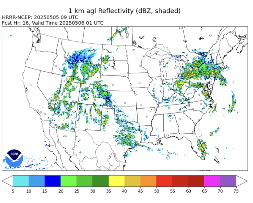
-
45 and steady moderate rain this morning. We get a few May days like this every year or two.
-
These are the classic summers I grew up with that I knew and loved. I have dim memories of 1977 (mostly because of the blackout.... I think there's a pun there somewhere, unintentional I assure you lol) but stronger memories of 1980, 1983, 1988, 1991, 1993, 1995, 1999, 2002. The summers in the 90s were when I was in college and enjoyed wonderfully sunny summers at the beach, I think those summers all the way up to 2002 were the best summers we've ever had, only usurped by 2010-2013 which also had wonderful weather. Since 2013 we just haven't had summers like that anymore. We haven't even had a stretch of 7 or more days of 90 degree heat in a row since 2002 (we had two that year and also two in 1999.)
-
The title didn't age well lol. Drought strengthening everywhere but Frederick where it always rains should of been the title lol. I had a mostly cloudy weekend with a few sprinkles.
-
Picked up approximately 1.04” yesterday. Saw a little bit of blue sky for about 5 minutes this morning. Then gone. 64 degrees
-
Central PA Spring 2025
Itstrainingtime replied to canderson's topic in Upstate New York/Pennsylvania
Nothing in Maytown since yesterday morning.


