All Activity
- Past hour
-

The February 22-23 Late Season Miracle: JV Disco/Banter Thread
wasnow215 replied to bncho's topic in Mid Atlantic
Never-and states have declared "state of emergency" plenty before things start for many years now. -
Comment all you want at each of the BS model issues , debbbie downers and upbeat amounts posting. Have fun. This old timer only looks at one one model right now ---the NAM and I am also someone convinced of the HRRR lately at this range. - all the rest are garbage for this type of storm event. I have seen and experienced all of the biggies from 1983, 2010, 2021 etc. At this range it is usually the NAM. While it appears a little on the high side right now at these OZ runs tonight, its going to be close depending who gets the deformation bands. These bands tend to fire up along the S Mtn range too so watch out - there will be screw zones. This map seems very plausible to me after doing this for 35+years Where is the thundersnow guys? This will be a defintley in the cards too. Sleet may cut the totals along the coast in the heavier bands
-
Correct
-
36/30
-

“Cory’s in NYC! Let’s HECS!” Feb. 22-24 Disco
40/70 Benchmark replied to TheSnowman's topic in New England
NAM has had that band locked since 12z while the GFS is ticking se and EURO is waffling. I am inclined to go NAM on that...especially since they often end up NW of where we think they will. -
The February 22-23 Late Season Miracle: JV Disco/Banter Thread
wasnow215 replied to bncho's topic in Mid Atlantic
Ok I've caught up on the banter thread after work but I do have a question. When we go to "storm mode" will all the Deb stuff that's so rampant tonight in the main thread have to be confined to banter? -

-
I'm pretty much at the saturation point of model watching. I'm going to try my best to stay off the forums tomorrow and just enjoy what I'm hoping is an entertaining storm. My goal is beating Januarys 16+ anything less than 12 now I think I'd be a little bummed. Good luck to all.
-

Feb 22nd/23rd "There's no way..." Obs Thread
EHoffman replied to Maestrobjwa's topic in Mid Atlantic
Hallucinating on pressure change maps is peak PHL-BOS HECS behavior on this board -

The February 22-23 Late Season Miracle: JV Disco/Banter Thread
AlexD1990 replied to bncho's topic in Mid Atlantic
Trixie, come on now. How many times in the past have we seen a state of emergency be declared hours if not a day before a major weather event? Don't be obtuse. -
There is a bit of an east shift in all the global guidance so far tonight. Not sure it’s really the time to be looking at global models but I feel like it can’t be completely ignored.
-
I drove through from Bethel to Holton and back this week and was surprised about the relatively low snow pack in a lot of the state. Trail crossings were beat in a lot of places. I didn’t ride in Maine but just across the border in NB, the trails east of the St. John’s valley were in nice shape but the locals were saying it was somewhat low compared to normal. The trails along the river were pretty thin.
-

Feb 22nd/23rd "There's no way..." Obs Thread
IUsedToHateCold replied to Maestrobjwa's topic in Mid Atlantic
I'm riding the NAM at this point. Model is good at this range. 33.6/29.2 I don't know what to say other than I've felt this storm for over a week now and everything that's happened this week has led me to believe this is going to be a big thing. Rest up because tomorrow we celebrate. -
Let me say that this Cory fellow has a heck of a track record. When do we set up a gofundme to send him out of town the days before Christmas next year? We'll get the Grinch to jump over the BM with that!
-

“Cory’s in NYC! Let’s HECS!” Feb. 22-24 Disco
78Blizzard replied to TheSnowman's topic in New England
Also, they have ARW, HRRR, RAP, and other mesos. -
The February 22-23 Late Season Miracle: JV Disco/Banter Thread
wasnow215 replied to bncho's topic in Mid Atlantic
It's just another stupid thing someone made up bc "emergency" is too harsh in 2026 in our western culture. -
BGR and BTV might be the only commercial fields in New England to see flights on Monday.
-

The February 22-23 Late Season Miracle: JV Disco/Banter Thread
Wxtrix replied to bncho's topic in Mid Atlantic
the storm hasn't started yet? -
“Cory’s in NYC! Let’s HECS!” Feb. 22-24 Disco
40/70 Benchmark replied to TheSnowman's topic in New England
18z EURO was Jan 2022. -
Stay safe
-
If they are coming in the morning … they might get canceled. If they are coming in the afternoon … they should be fine. If they think they are going to find an open seat … ha.
-
Probably tracks a bit further north. A good hit for southern Wisconsin. .
-
your right after the dec 2010 blizzard 19 inches in january storm and then winter was over for nyc..memory is the first that goes when you get older..
-

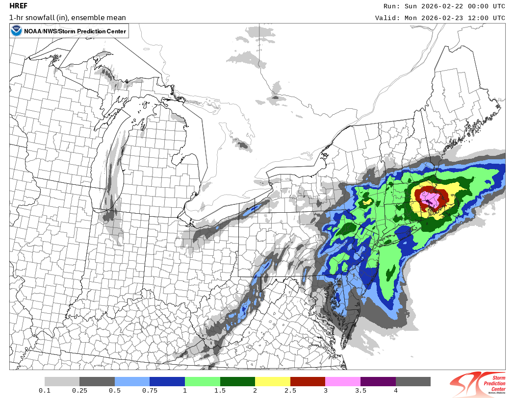
“Cory’s in NYC! Let’s HECS!” Feb. 22-24 Disco
ma blizzard replied to TheSnowman's topic in New England
HREF is nuts .. look at these rates 12z Monday
-
Read about the Blizzard of 1888.