All Activity
- Past hour
-
Models are shifting the vort north at the last minute (sound familar?) Not like we were going to get more than flurries anyways.
-
We’ll see if this can trigger a strong enough wave reflection to lead to more of a -WPO -EPO from late November into early December. Then the main question is will it be able to weaken the Pacific Jet enough. Last December we saw how the stronger -EPO didn’t really weaken the jet enough so we got a mid to late December +EPO reversal. Remember none of the models got this +EPO reversal later in December from early in December. So we’ll just have to monitor the Pacific Jet once we actually get into December. Plus we have seen warm ups every December since 2011 from the 17th to 25th that most of the long range models missed. Even during colder starts to the month.
-
Happy Birthday!
-
I'm surprised to see thunderstorm activity on radar in the area. I wasn't expecting anything until this evening. Yay! Something besides boring and beautiful lol
-
First off welcome to NYC! And second no it’s not like you are in Times Square lol.
-

November 2025 general discussions and probable topic derailings ...
powderfreak replied to Typhoon Tip's topic in New England
The only storm you’re gonna find 18”+ around BOS and BTV both. -

11/8-11/10 First Snow and Lake Effect Event
King James replied to Geoboy645's topic in Lakes/Ohio Valley
4 feet lol -
November 2025 general discussions and probable topic derailings ...
powderfreak replied to Typhoon Tip's topic in New England
Fresh dusting of white outside this morning.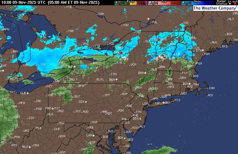
-
Oooh interesting that it’s uniquely bad compared to the rest of the city—any reasons why? I’m only a block from prospect park though, so hoping on getting to see some snow stick there
-
Trying hard to believe in the process, but it’s been a biiiit of a circus to say the least at times. 2 wins in a row now though! We went from having no defense and a killer offense the past few years to now having a decent defense but no offense.
-

11/8-11/10 First Snow and Lake Effect Event
sbnwx85 replied to Geoboy645's topic in Lakes/Ohio Valley
Oh and quite a snippet from the LOT AFD By the time the lake effect ends on Monday, total snow amounts will vary considerably across short distances. Where the snow bands are most intense, total snow accumulations of 12 to 18 inches are expected with a ceiling of 2 to 4 feet if snow bands end up stationary. This threat appears to be most pronounced over Cook county, but may extend to Lake County Illinois and Lake County Indiana, as well. -
11/8-11/10 First Snow and Lake Effect Event
sbnwx85 replied to Geoboy645's topic in Lakes/Ohio Valley
Potential for historic snows in the city! The mesolow looks to come ashore out here in Indiana (which keeps me in the game for a potential big dog) but it will be what dramatically shifts the main band into Chicago. Considering how deep the cold air is and how warm the lake is, expect at least 3” per hour rates. This is an extraordinary set up, so 6-8” per hour isn’t out of the question at times. I’ve only experienced 4” per hour snows once in my life and it was bonkers. It’s exciting but be ready to have your heart broken. This is Game 7 of the World Series, tied at 4-4 in extra innings. It could be glory or it could be nothing. The band and mesolow will ultimately do what they want but this is as good of a setup for Chicago as I’ve ever seen. I’m hoping the band shifts back east and holds together for a few more inches on Monday. -

November 2025 general discussions and probable topic derailings ...
dendrite replied to Typhoon Tip's topic in New England
35.9° with a few spits. Didn’t see a sign of any frozen. Low was 35.1°. -
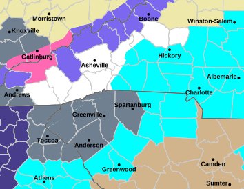
Madison-Yancey-Mitchell-Haywood-Graham- Including the cities of Faust 120 AM EST Sun Nov 9 2025 ...WINTER WEATHER ADVISORY IN EFFECT FROM 7 PM THIS EVENING TO 7 AM EST TUESDAY ABOVE 3500 FEET... * WHAT...Snow expected above 3500 feet. Total snow accumulations up to 4 inches, with higher amounts possible above 5000 feet. Winds gusting as high as 45 mph. * WHERE...Graham, Haywood, Madison, Mitchell, and Yancey Counties. * WHEN...From 7 PM this evening to 7 AM EST Tuesday.
-

Fall 2025 WX Discussion Thread
Holston_River_Rambler replied to Carvers Gap's topic in Tennessee Valley
New graphic as of 5am eastern from MRX: Watches, advisories, and warnings: Some key goosies from teh overnight Disco: As such, I am highly confident there will be widespread snow showers across at least the northern half of the CWA, if not the northern two thirds of the CWA during that time. It`s entirely possible some locations could pick up an inch of snow or more - one might even say it`s likely. However, confidence in where exactly that occurs is very low. Recent ensemble data shows increasing confidence in a notable snowfall event for the Smokies, with probabilistic data giving high confidence in snowfall totals exceeding 8 inches. The evening shift updated the totals to include an 11" total for Mount LeConte area, and Newfound Gap won`t be too far behind that I don`t believe. Went ahead and upgraded the Watch to a Winter Storm Warning because of this. Additionally, there`s sufficient confidence in snowfall totals exceeding Advisory level criteria elsewhere in the east TN mountains and the higher terrain of our Virginia counties, so I added an Advisory to those areas, grabbing Monroe county on the southern end too. There`s signal in the higher resolution guidance that shows Sams Gap area along the I- 26 corridor closing in on the 5-6" range; I wouldn`t be surprised if the High Knob area in Wise county winds up with something similar. Elsewhere, other areas in the advisory should be covered just fine with the 1-4" totals. It`s highly likely that some adjustments or outright expansion of snowfall totals, areal coverage of these headlines, or both, will be needed on the day shift today. -

-
Fall 2025 WX Discussion Thread
Holston_River_Rambler replied to Carvers Gap's topic in Tennessee Valley
I haven't started any subscriptions yet, so I don't have access to all the fun charts, but I pulled 0-3km CAPE and lapse rates on the RAP on the COD site from 12z Monday through about the next 20 hours CAPE: Low level lapse rates: Can we praise the sun angle for this one, lol? Euro throws out some 700 mb frontogenesis: Really helps this vort. is rolling through at what peak heating we will have. No matter how you slice it, it looks like we will have moisture, lift, and cooperative temps. Thankfully this isn't October, so we don't have that La Nina kiss of death. Euro and RGEM take the vort. right over my head in Morgan County. NAMs like TRI, SWVA and Eastern KY. GFS looks like MRX gets the overhead pass. -
Not a bad look for the first snow of the season. Sent from my SM-G998U using Tapatalk
-
11/8-11/10 First Snow and Lake Effect Event
sbnwx85 replied to Geoboy645's topic in Lakes/Ohio Valley
1.5” from the system. Hopefully it doesn’t all melt before the lake effect kicks in. -
Swain- 120 AM EST Sun Nov 9 2025 ...WINTER STORM WARNING IN EFFECT FROM 7 PM THIS EVENING TO 7 AM EST TUESDAY ABOVE 3500 FEET... * WHAT...Heavy snow expected above 3500 feet. Total snow accumulations up to 8 inches in the Smokies. Winds gusting as high as 45 mph. * WHERE...Swain County. * WHEN...From 7 PM this evening to 7 AM EST Tuesday.
- Today
-
BWI: 12.9” DCA: 9.7” IAD: 15.3” RIC: 8.1” SBY: 9.8”
-
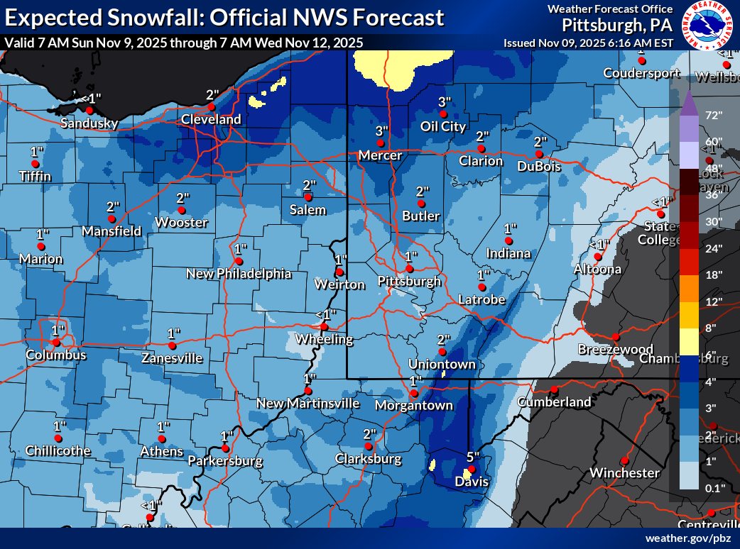
Chicago forecast is wow
-
 Winner
 -
11/8-11/10 First Snow and Lake Effect Event
King James replied to Geoboy645's topic in Lakes/Ohio Valley
Winter storm warning all the way down here in East Central IL for up to 10 inches lol. We’re back boys! -

11/8-11/10 First Snow and Lake Effect Event
A-L-E-K replied to Geoboy645's topic in Lakes/Ohio Valley
Are they 4 real?