All Activity
- Past hour
-
Humidity taking its time leaving the area. Dews now in the upper 60s to around 70 with light northeast winds. This upcoming weekend is going to be glorious
-
 So a case could be made for a forecast for 1/2 inch to 1/2 foot.
 -
The last forecast for the week of 8/25 off the weeklies and it turned out to be the coldest forecast of all!

-
You need to find a new hobby...... Your posts are pretty annoying and don't contribute anything to this board.
-
I think most logical folks on here, including me, would agree that winters back can be broken in mid-late February. Winter just doesn’t feel the same after that period, just as summer does not feel the same from here on out
-
Looks like Bradish and Wells will be back in the Bigs and pitching in the next 2 weeks. https://www.baltimorebaseball.com/sports/orioles-mlb/2025/08/18/bradish-return-orioles-starting-rotation-next-week-richdubroff/ Add them to Rogers and Kremer, and you have the makings of a solid rotation with Povich and others in the mix, and Grayson possibly back next season. That said, can't count on so many guys rebounding from serious injuries, so we need an actual GM who will be aggressive in signing a top tier pitcher in the offseason.
-
It’s more meant for this region that the back is broken. It certainly isn’t broken for the central US yet since there can still be consistent 85-90 humid days right through Columbus Day.
-

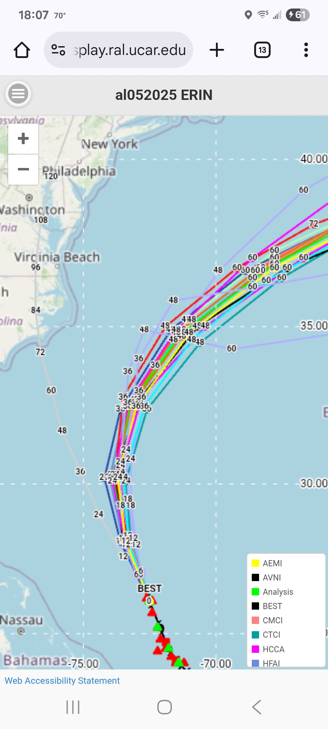
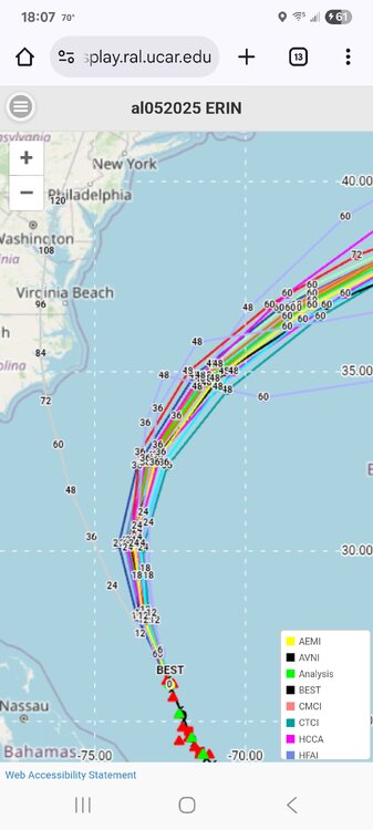
Hurricane Erin: 105 MPH - 958 mb - NNW @ 10
Wannabehippie replied to BarryStantonGBP's topic in Tropical Headquarters
blob:https://www.tropicaltidbits.com/c74331c1-1b1b-435a-8166-7aba6cb3281f -
 WE GOT HIM changed their profile photo
 - Today
-
High of 88. Very humid today and that gave us a surprise thunderstorm. Ended up with .28". Now at 8.62" for the month.
-
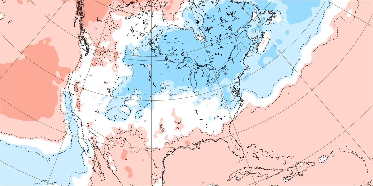
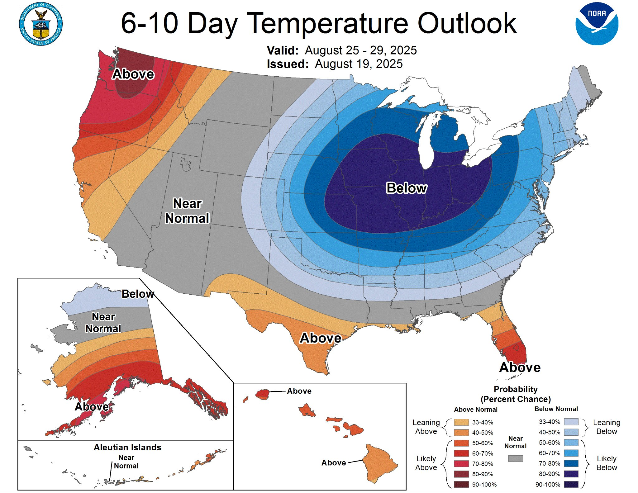
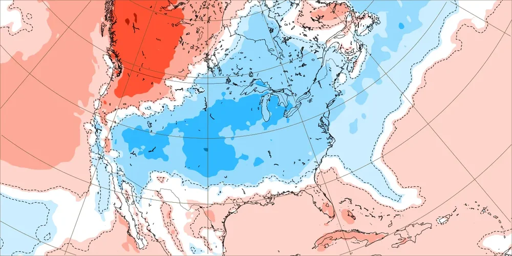
Looking at the latest ens means, nothing but normal to below normal temps in sight through the end of the month and into the beginning of Sept. Once Erin passes, dewpoints will be in the comfortable range. Looks like some of the upcoming nights will feature temps in the mid to upper 50s. Bring it!
-

Hurricane Erin: 105 MPH - 958 mb - NNW @ 10
NJwx85 replied to BarryStantonGBP's topic in Tropical Headquarters
Erin is looking good again. I suspect we’ll see an eye sometime this evening. -

Hurricane Erin: 105 MPH - 958 mb - NNW @ 10
wthrmn654 replied to BarryStantonGBP's topic in Tropical Headquarters
-
Here's another great one. Incredible camera resolution. If you're on your phone, be sure to turn it horizontally for a full screen view. https://avalonpier.com/piercam/
-
Watches extended a little further north.
-

Hurricane Erin: 105 MPH - 958 mb - NNW @ 10
GaWx replied to BarryStantonGBP's topic in Tropical Headquarters
This is a good illustration of a hurricane transferring warmth from the tropics to higher latitudes, the role of hurricanes. Otherwise, the tropical waters would be even hotter. -
 Mt holly isn't impressed by heavy rainfall chances
 -
Hurricane Erin: 105 MPH - 958 mb - NNW @ 10
wthrmn654 replied to BarryStantonGBP's topic in Tropical Headquarters
Yeah but I didn't realize it's 87 miles east of Erin. -
Hurricane Erin: 105 MPH - 958 mb - NNW @ 10
GaWx replied to BarryStantonGBP's topic in Tropical Headquarters
But look how much it cooled due to the energy transfer to Erin as potential energy in form of ocean warmth was converted to kinetic energy. -
It certainly is, my 5 year old grandson now has a cousin. Bone dry out there, level drop is evident in some stressed trees, only .35” for the month here.
-
A big problem has been the upper latitude pattern. This big ridge in the N. Pacific is -PNA Here's the Winter sea-level pressure pattern with PNA (map is default positive, so what's happened lately is opposite of this map) ^Notice the low SLP off the east coast. -0.3 is pretty significant correlation. We've been seeing -PNA (North Pacific pattern), so there has been more tendency downstream for High pressure along the east coast and off the coast. That's just the Pacific.. in the Atlantic since 2011-2012, 83% of the Winter months have had +NAO! In that time monthly NAO readings of >1.11 have been positive 18-0. Here's the SLP correlation with NAO, this map is default positive so in +NAO, like we have seen lately, it is like this Again, very High pressure correlation. Add the Pacific and Atlantic upper latitude patterns together and you have 5x more likely to have east coast, or off the east coast, High pressure vs Low pressure in the Winter months. That's the pattern we've been in since 2011-2012 and more so since 2016-2017. A core reason for this is the decadal La Nina state that has been in place since 1997-1998. Some say -PDO, but the Hadley Cells are flexed in the southern Hemisphere too so it's been more Nino 3.4 driven, imo. Atlantic NAO is a decadal cycle, since the 1800s there have been 4 swings between positive and negative. They usually last 30-50 years at a time. We have been in the middle of a +NAO decadal cycle. Of course the jet stream is moving north with global warming, but it's been bad timing with regard to long term global pattern fluctuations.
-
UHI acts as an amplifier of mostly the low temperatures in and around Phoenix leading to the rapid increase in 80° minimums there. But the rapid increase in 100°+ maxes is evenly distributed across, urban, suburban, and rural locations. It’s the rapid warming of the planet which is driving the increasing intensity of the heat. So the UHI acts to keep the urban centers warmer at night than the outlying areas. But both areas as seeing steep increases in the minimum and maximum temperatures. So without the background warming of the climate, the UHI alone wouldn’t be nearly as significant.
-

Mid to long range discussion- 2025
WinstonSalemArlington replied to wncsnow's topic in Southeastern States
-
Right, no one is disputing it's been hot in Flagstaff. It just hasn't warmed as much as Phoenix, as those stats clearly show. It's a distinct difference. - Two of Flagstaff's top 3 warmest summers happened more than 20 years ago. Meanwhile, those same two summers are tied for 6th hottest in Phoenix, and their three hottest are the last three summers. - Flagstaff has 5 summers among their 10 warmest that occurred 2007 or earlier. Phoenix has 2. - Flagstaff has a total of 7 20th century summers on their list. Phoenix has 3. - Phoenix's hottest summer is more than 4 degrees warmer than their hottest 20th century summer. Flagstaff's is less than 2 degrees warmer.
-
Yessss !!!