All Activity
- Past hour
-

September 2025 OBS-Discussion centered NYC subforum
wdrag replied to wdrag's topic in New York City Metro
smooth it for now... its raining today and that was relatively dismissed-underestimated by media communicators. VERY unusual pattern for Sun-Mon so not a lock 1.5"+ but am pretty sure many of us will see more rain than that which occurs today. -
As I've gotten on into middle age-dom, my winter anticipation has changed. I'm not just like this guy at the mere thought of winter anymore. There's all kinds of rules now. Like, if it is going to be a perpetual 44 F with wind over bare earth boning? Leave the region and don't leave any forwarding contact information - it doesn't exist while gone. Out of sight. Out of mind. Even if there's a threat in there some-whence, it's too late. No interest. Winter is hell. F you! However, if winter is actually going to perform like a Rockwellian nostalgia? I'm all in. The problem is, due to CC's one-eyed bum monster, the boning option is probabilistically favored. <-- that simple sentence causes internet fights, but when the dust settles, it's still unfortunately true.
-
Probably a bit of actual measurable rainfall in and around NW PGC and SE Moco this AM. Very light though.
-
late April, early May vibes
-
Surface dews in the 60s, LIs -4, 1000-2000 joules of CAPE.... I'll take my chances.
-
Cloudy again
-

September 2025 OBS-Discussion centered NYC subforum
Rmine1 replied to wdrag's topic in New York City Metro
Brightwaters: rain, 63 -

Mid to long range discussion- 2025
WinstonSalemArlington replied to wncsnow's topic in Southeastern States
An early frost? -
A few light showers/storms, mostly WNE. Nbd
-
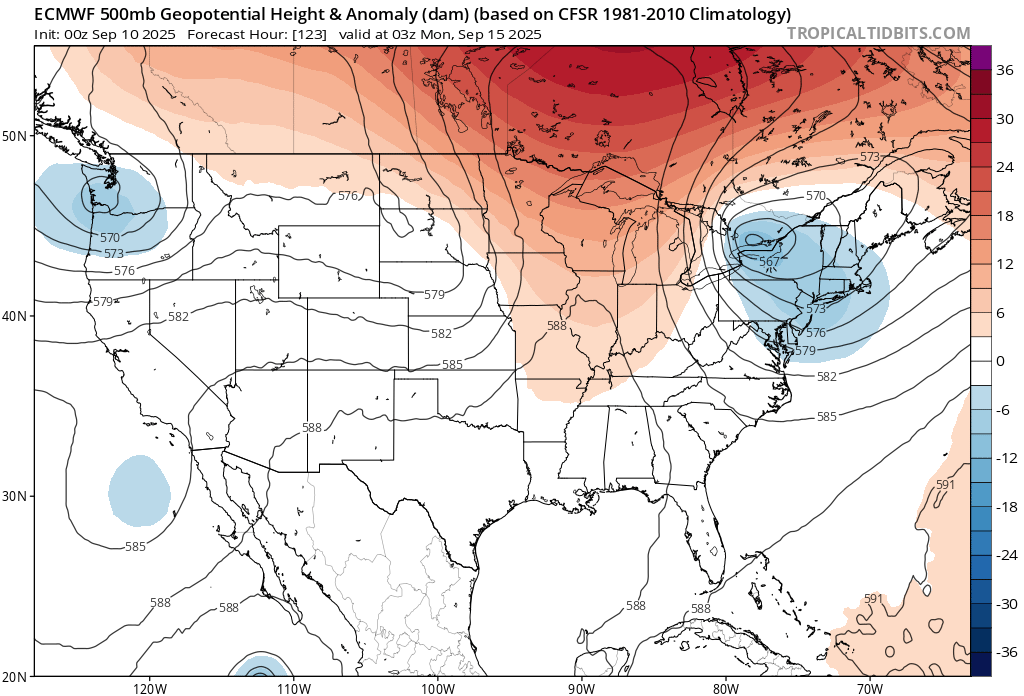
Ha ha... without even a local, either. no but but seriously, it's like they ran this frame from my cellar. I've been ruminating - much to the chagrin of others ... - that I don't see how/why the wind scarped, shear stressed, resonance failing high variance winters of the last 10 years won't simply repeat, despite all leading indicators and that most confidence inspiring metric off all: spontaneous crowd physics emerged cause for exuberance. LOL If you can ferret out some usefulness in that super nova of adjectives, it goes something like a repeat of recency. But yeah... I mean not in an absolute sense. Tendency to do so... I think our best shot at avoiding that absoluteness ... would be the ~ mid Nov to early Jan span. After that ... we'll see on the SSW/AO modulation stuff - I have to tell you though ...I am one of the original SSW guys from 20 years ago. I used to hammer the theoretical side, replete with graphical displays and annotated charts. I have since toned it down, however ... Because, I've noticed over the years that despite the correlation between (specifically...) down-welling stratospheric warm plumes ( i.e., not merely having a warm plume present - huge comprehension problem with this still exists ...), the -AO response then has a less correlative forcing on the temperature distribution at mid latitudes. Note, less does not mean no - it implies not all -AO's have the same talent. This is a-priori evidenced in the fact that there's a maelstrom of mid and lower latitude teleconnectors that come along with their own capacity to overwhelm. That can mean everything from a general offset, to forcing events over in Asia.. .etc.. Basically, we need to have a constructive interference after the fact of a down-welling AO, to really make it useful/correlate to our wintry results. Otherwise, the transience of the -AO response can come and go with variable actual fruit to bear. The other aspect is that these SSWs and or just warm intrusions at higher latitude, seem to happening later in the seasons - not enough data for confidence here.
-
As you travel through Frederick, if you are going highway speed, you can see a little drizzle on the windshield....
-
I was just looking at that. Certainly an interesting evolution. Cold pool for the win?
-
Wouldn't mind a bit of rain, but otherwise it is pretty spectacular run we got coming here. 80/55 every day for the next week+.
-
I still suggest this should be watched on Sunday ...
-
Cansips look good
-
Peak Hurricane season. Really?
-
Currently 61. Should be a perfect Fall day with mid-60's and drizzle later on.
-
I like the soutern US anomalies again. Lets get a snowy NNE and srn US and porked in SNE.
-
I'll take the clouds and drizzle. Mainly the drizzle
-

September 2025 OBS-Discussion centered NYC subforum
FPizz replied to wdrag's topic in New York City Metro
59 with some on and off light rain. - Today
-

2025-2026 ENSO
40/70 Benchmark replied to 40/70 Benchmark's topic in Weather Forecasting and Discussion
It least he has a few flakes dancing around the bad news -

September 2025 OBS-Discussion centered NYC subforum
bluewave replied to wdrag's topic in New York City Metro
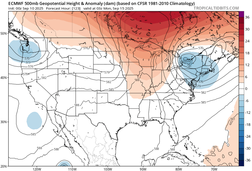
Yeah, hoping the Euro is correct about the heavy rain potential with the omega block and cutoff low next week.
-
Yeah I’ll take the early 40s for sunshine
-
September 2025 OBS-Discussion centered NYC subforum
wdrag replied to wdrag's topic in New York City Metro
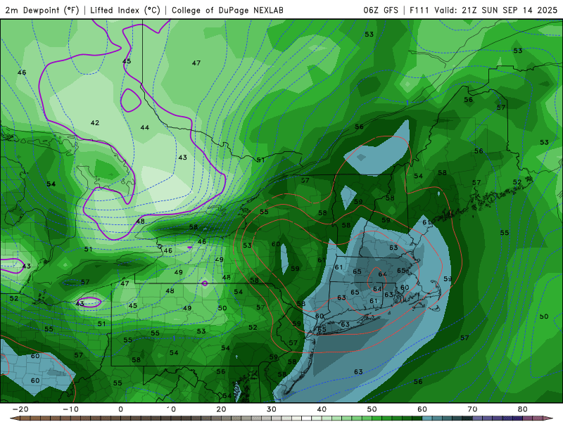
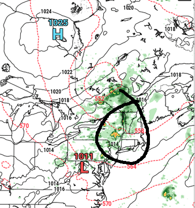
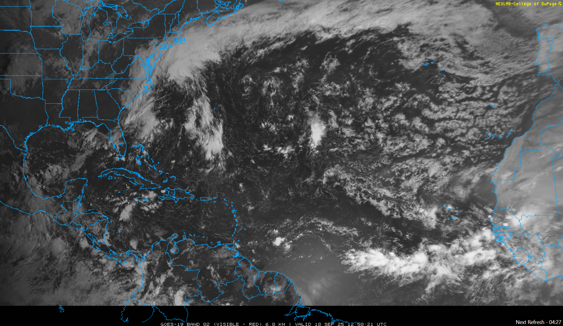
So... I see very little mPing on the on going sprinkles to moderate showers occurring NJ/LI/NYC area... a little disappointing. I see .08 in 1 hr vicinity LGA in the last hr or two. Lets see how fast the clouds go away from the coasts... could be a day or two? How about the 16z Sunday-06z/Tuesday showery event... unusual pattern development but possible and ensembles agree, except the lightest GEFS which seems to be lagging. I'll side with the EPS/CMCE on this one and those who have plans late Sun or Mon ,may want to consider raincoats etc. -
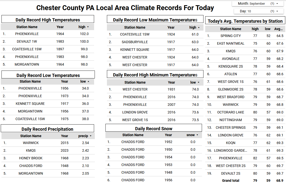
We have picked up some unexpected light rain that has resulted in at least 0.05" across some spots in the county this morning. These showers are backing off the ocean from a small storm off the NJ coast. There could be a couple more showers and clouds today with a continuation of our below normal temperatures. Sun returns tomorrow and we should have a great weekend with low humidity but slowly increasing temperatures. We may get near or slightly above normal by Friday before we turn a bit cooler again at the start of next week.


(002).thumb.png.6e3d9d46bca5fe41aab7a74871dd8af8.png)