All Activity
- Past hour
-
Actually pretty darn close lol
-

January 25-26 Winter Storm Potential
Army Mike replied to Ralph Wiggum's topic in Philadelphia Region
Does it look at HR36 of the 00Z Nam that the cold press seem a tad more stout with would help flatten the heights and bring in more of stronger cad. I'm learning more now that i have the time but if I'm off please forgive me -
Welcome to the board! GFS usually starts around 10:30
-

January 24-26: Miracle or Mirage JV/Banter Thread!
snowfan replied to SnowenOutThere's topic in Mid Atlantic
I’m ingesting a barrel aged stout -

January 25-26 Winter Storm Potential
The Iceman replied to Ralph Wiggum's topic in Philadelphia Region
Time to brew some coffee and smoke a joint before the 00z suite rolls in, I suggest others do the same -
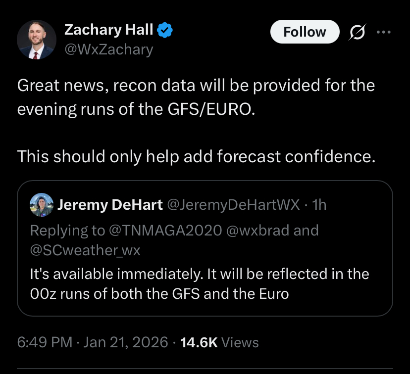
I don't think we got a firm clarification, but I believe the NAM doesn't have the recon data in it, just FYI
-
OMG Frankie! I haven't heard from him in years, glad he's still at it! To hear him do Tennessee... nearly brings a tear to my eye.
-
I’d take 1/4 of that and be happy. .
-
Blacksburg posted in their discussion at 1:30 this afternoon that there was 30-40% chance of 10"+ snow for their NC counties.
-
Yea that’s quite an improvement from the NAM
-
So the heres a run of the euro from way back when it had the snow max in southern virginia... Here is the 0z NAM Clearly they are not the same setup. Need to see how that NS entering the Pac NW interacts with it. Additionally, the huge jumps north are from a different NS lobe that only enters our viewing angle at hour 60.
-
 Both were clippers, if I recall correctly.
 -
Can't help but think back to Jan 25, 2000 and the papers that were written after that surprise. Models and mets together were focusing on the wrong sw feature all the way up til 36 hrs prior. Maybe we are victims of something similar here. Not sure what surprise would be in store. Just thought it was funny we sitting here not sure what we are hoping for, same date 26 years later, same dilemma.
-

MO/KS/AR/OK 2025-2026 Winter Discussion
NWAflizzard replied to stormdragonwx's topic in Central/Western States
Saw this on Twitter. Interested to see if it changes anything.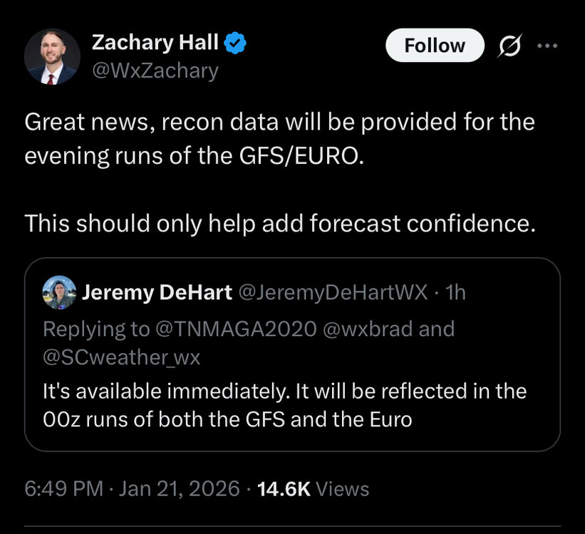
-
Nam has features closer to 18z gfs up to this point
-
Man I be holding my breath during 0z GFS. Telling you nothing will shock me when the new data is taken in
-
I guess Cheeznado doesn't visit this board anymore? He was usually a good source to follow in lead ups to a storm
-

“Cory’s in LA! Let’s MECS!” Jan. 24-26 Disco
moneypitmike replied to TheSnowman's topic in New England
From your keyboard to God's ears. -

January 25/26 Jimbo Back Surgery Storm
Brick Tamland replied to Jimbo!'s topic in Southeastern States
Just saying the huge jump by the Euro from yesterday morning to this morning is pretty ridiculous. -
“Cory’s in LA! Let’s MECS!” Jan. 24-26 Disco
moneypitmike replied to TheSnowman's topic in New England
The CON one makes me feel sick as to what the PWM or IWI ones look like. I only want good news. -
Look at what you see now. Then wait to see if the end result is better than before. If it is, then what you saw is what you were looking for.
-
I doubt it...it's going to come out..but there are some differences. Like I said, I don't know if it means much tho
-
Baja low at 30 looks like it wants to get comfy and bury itself out there. 50/50 maybe slightly better?
-

January 25/26 Jimbo Back Surgery Storm
Coach McGuirk replied to Jimbo!'s topic in Southeastern States
https://www.tropicaltidbits.com/analysis/models/?model=gfs®ion=seus&pkg=asnow&runtime=2026012118&fh=120 -
That Baja low is not budging...