All Activity
- Past hour
-

January 2026 regional war/obs/disco thread
Patfan1987 replied to Baroclinic Zone's topic in New England
I don’t know, make it stop! Mods, please delete, apologies -
My wife encourages boys trips to Vegas, she just asks me not to come back.
-
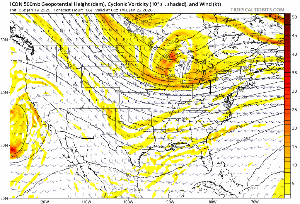
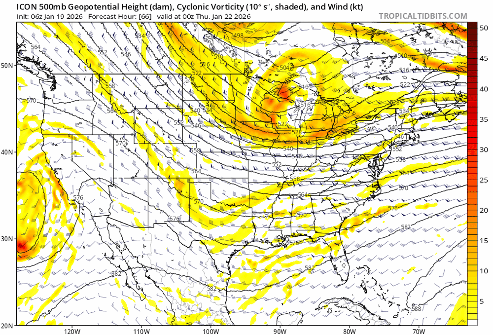
Just a reminder, both 06z and 18z ICON only go out to 120
-

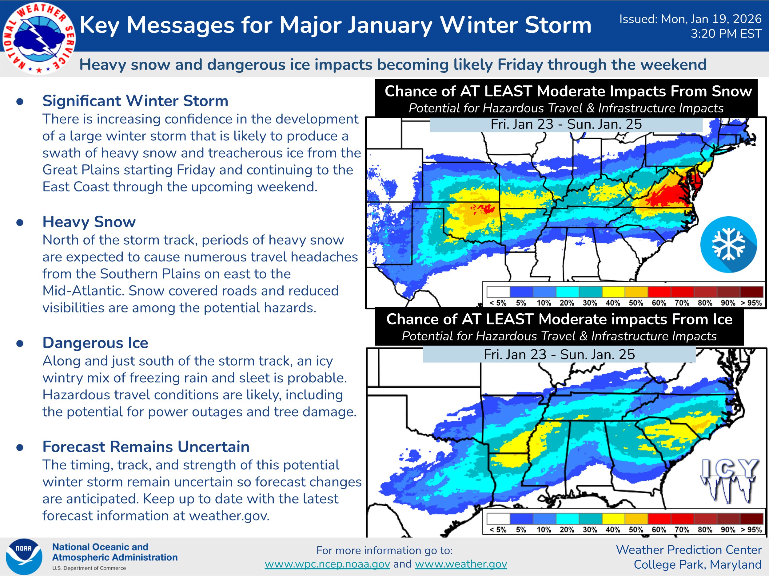
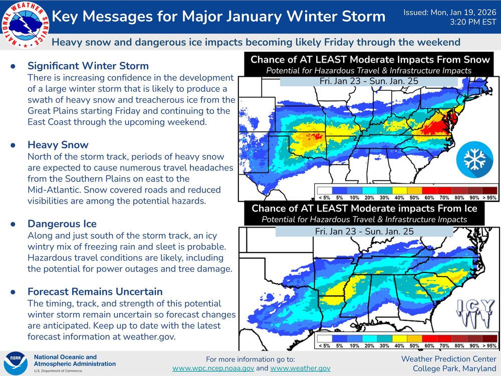
Possible Record Breaking Cold + Snow 1/23 - 1/25
Nibor replied to TriPol's topic in New York City Metro
Tomer is always a good read: https://x.com/burgwx/status/2013344401687236921?s=20https://x.com/burgwx/status/2013344401687236921?s=20 https://x.com/burgwx/status/2013346185 -
Icon coming out and SW is NE so far comparing the runs.
-

January 2026 regional war/obs/disco thread
HoarfrostHubb replied to Baroclinic Zone's topic in New England
What the heck was that? -
-
@Ralph Wiggum mentioned in the other sub that across all guidance the high weakened slightly from thr 1050s to 1044 at the most
-
Very generally speaking, thunder snow is reserved for storms that deepen rapidly near your latitude (bomb out) or less commonly a vigorous closed upper level low pass creating instability and pockets of big lift. I don't really see either with this event yet so my guess is no. There's a big thermal gradient but otherwise not a bomb scenario or gnarly closed upper level low.
-
https://x.com/i/status/2013350503464227182
-

E PA/NJ/DE Winter 2025-26 Obs/Discussion
Maestrobjwa replied to LVblizzard's topic in Philadelphia Region
I think that'll be good for both our subs...because a weakee high would lessen suppression risk, right? -
Can’t say I hate being on the north side of the heaviest snows as depicted by the nbm. Still a little worried about suppression, but 12z assuaged that concern just a little bit.
-
yeah after the second storm, we had like 4' of snow on the ground in Philly. Unreal.
-
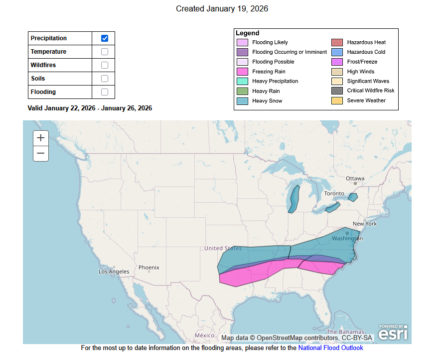
Cold. Here's the precipitation:
-
So my big question is, who has the plow to pick up me and the surgical team so this doesn’t get cancelled lol .
-
January 2026 regional war/obs/disco thread
Patfan1987 replied to Baroclinic Zone's topic in New England
Apple home grown weather app has me at [emoji[emoji638][emoji639][emoji[emoji6[emoji640][emoji638]][emoji640][emoji640]][emoji[emoji6[emoji640][emoji638]][emoji640][emoji6[emoji640][emoji637]]]][emoji[emoji638][emoji639][emoji[emoji6[emoji640][emoji638]][emoji640][emoji640]][emoji[emoji6[emoji640][emoji638]][emoji640][emoji6[emoji640][emoji637]]]]-[emoji[emoji638][emoji639][emoji[emoji6[emoji640][emoji638]][emoji640][emoji640]][emoji[emoji6[emoji640][emoji638]][emoji640][emoji6[emoji640][emoji637]]]][emoji[emoji[emoji638][emoji639][emoji[emoji6[emoji640][emoji638]][emoji640][emoji6[emoji640][emoji637]]][emoji[emoji638][emoji639][emoji[emoji6[emoji640][emoji638]][emoji640][emoji640]][emoji[emoji6[emoji640][emoji638]][emoji640][emoji640]]]][emoji639][emoji[emoji6[emoji640][emoji638]][emoji640][emoji6[emoji640][emoji637]]][emoji[emoji638][emoji639][emoji[emoji6[emoji640][emoji638]][emoji640][emoji640]][emoji[emoji6[emoji640][emoji638]][emoji640][emoji6[emoji640][emoji637]]]]] inches. That’s what’s causing the drama haha -

Central PA Winter 25/26 Discussion and Obs
Jns2183 replied to MAG5035's topic in Upstate New York/Pennsylvania
Are those by days of snow individually or do you compress multiple days to one storm. If you want I can send you how I did Harrisburg as well as raw data going back to 1890 Sent from my SM-S731U using Tapatalk -
That really is a pretty good clustering showing up on today's run.
-
Doesn’t have the Euro correct? .
-

Possible Record Breaking Cold + Snow 1/23 - 1/25
Big Jims Videos replied to TriPol's topic in New York City Metro
hoping this is the real deal and not a "premature evaluation." -

Possible Record Breaking Cold + Snow 1/23 - 1/25
weatherpruf replied to TriPol's topic in New York City Metro
looks like the storm that shall not be named.....2/6/2010. this is not quite as massive though. -

January 2026 regional war/obs/disco thread
dendrite replied to Baroclinic Zone's topic in New England
I was just looking up the 1933 data from all of the NH sites and there’s a lot of -40s in Coos, but 2 stood out…-48° in Milan and -52° in Dixville Notch. Unfortunately they were stamped with “not standard thermometer” on the forms. -
If you compare h5 to gfs the sw is moving east and is already east of gfs. But its the Nam at 84 so ain’t like it matters.
-

January 2026 regional war/obs/disco thread
weathafella replied to Baroclinic Zone's topic in New England
I gotta fly 2/1 to FL to care for my MIL-was originally planned the first week of March but alas stuff happens. She can’t be alone and my wife’s siblings are/were there last week, this week, and next so our time is coming except since my wife and me are the only ones with more time. Let’s get a big dog before 2/1! After that our winter is over. -
Yea agreed, this is why I asked. Just looks like the OPs .