All Activity
- Past hour
-

First Winter Storm to kickoff 2025-26 Winter season
H2Otown_WX replied to Baroclinic Zone's topic in New England
Do we value them? Is AI doing better than the regular Euro? -
-

December 2025 regional war/obs/disco thread
H2Otown_WX replied to Torch Tiger's topic in New England
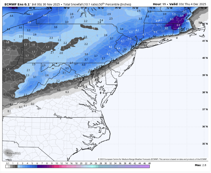
Man, that was one hell of a weenie run from the 00z Euro. Guess it can only get worse from here lol. I imagine December '95 was a bit similar to what it's showing. No KU but just a nickel 'n dime pattern with 3-6/4-8" type events every 5 days or so. -

Nov 28-30th Post Turkey Day Winter Storm
Chicago Storm replied to Chicago Storm's topic in Lakes/Ohio Valley
8.4" at ORD as of midnight. 8.0" at RFD. This snowstorm is now tied for the 5th largest on record in November for Chicago. -

First Winter Storm to kickoff 2025-26 Winter season
40/70 Benchmark replied to Baroclinic Zone's topic in New England
Man, EURO AI ens are enfuego. -

Central PA Fall Discussions and Obs
Superstorm replied to ChescoWx's topic in Upstate New York/Pennsylvania
Euro bumping things up. . -

Nov 28-30th Post Turkey Day Winter Storm
cyclone77 replied to Chicago Storm's topic in Lakes/Ohio Valley
10.3" here as of midnight. Still snowing decently with this final rotating swath of snow. It's now been snowing over 24 hours. Super high quality event. -

First Winter Storm to kickoff 2025-26 Winter season
40/70 Benchmark replied to Baroclinic Zone's topic in New England
That is a great mid level look up here. -
Cold rain after cold rain on the Euro the next few weeks. Give me warm and dry if its not going to snow.
-
Meteorological winter starts tomorrow so I think it’s time to start this thread. We have a storm threat for Tuesday that looks like rain/slop for I-95 but N&W areas could see something plowable. Some fantasy range threats on the GFS/Euro too that can hopefully become something as we get closer. Let’s get this party started!
-
December 2025 Short/Medium Range Forecast Thread
John1122 replied to John1122's topic in Tennessee Valley
The Euro is trying to slip in some heavy frozen precip along the back side of the system on Tuesday. -

Nov 28-30th Post Turkey Day Winter Storm
Jebman replied to Chicago Storm's topic in Lakes/Ohio Valley
Congrats on the snow! Looking forward to your reports deeper on into this winter, should be a good one up in those parts. -
I do not know with the way the Highs are sitting. Looks like maybe a little ice could be possible, but that is a poor look
-
Not this run. Lol
-
I think there's a combination of rain/sleet/snow at the start but otherwise mostly rain nearer the coast possibly heavy at times. I'm more interested in Friday night. WX/PT
-
First Winter Storm to kickoff 2025-26 Winter season
8611Blizz replied to Baroclinic Zone's topic in New England
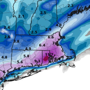
Cory gets his squeeze box crushed. -

First Winter Storm to kickoff 2025-26 Winter season
WxWatcher007 replied to Baroclinic Zone's topic in New England
Yeah solid stuff all the way to the CT coast. -
Euro looks to be getting ready for next weekend too.
-

First Winter Storm to kickoff 2025-26 Winter season
8611Blizz replied to Baroclinic Zone's topic in New England
-
We're never happy!
-
First Winter Storm to kickoff 2025-26 Winter season
78Blizzard replied to Baroclinic Zone's topic in New England
Looked more than a touch. -

Nov 28-30th Post Turkey Day Winter Storm
sbnwx85 replied to Chicago Storm's topic in Lakes/Ohio Valley
8.8” in the backyard. -
winter_warlock started following Miss "local on the 8's"? Here it is...
-
Miss "local on the 8's"? Here it is...
winter_warlock replied to gtg947h's topic in Weather Marketplace
Me too!!! -
Wow! Euro would make us happy!
-

Nov 28-30th Post Turkey Day Winter Storm
Jackstraw replied to Chicago Storm's topic in Lakes/Ohio Valley
Got some confirmed pingers on the windows! lol. Now, get some freezing rain and that'll fill the kitchen sink

