All Activity
- Past hour
-
Now 10/60 @BarryStantonGBP
-
After last year's 4th hottest summer on record nationally, I'm guessing 2025 ended up somewhere in the 15th to 20th range.
-
0.36" for August. That was all fun and games but I don't want a repeat.
-
Leaves falling like early October here, been so for about a week. Mostly poplars and cherry, but a couple oaks showing a bit of color. I've already mowed/blown leaves off the yard and driveways twice.
-

September 2025 OBS-Discussion centered NYC subforum
qg_omega replied to wdrag's topic in New York City Metro
Look at above Russia -
Beautiful day today. High of 85, low of 65. Nice breeze. I'm seeing a couple 90 degree days Thursday and Friday. Zero rain in sight, getting dry already around here.
-
We've said it before. It's winding up like a spring again. It might be one, two, or maybe even 5 years from now, but it is CERTAIN that the global average temperature WILL go up and set a new record in the not too-distant future.
-

September 2025 OBS-Discussion centered NYC subforum
donsutherland1 replied to wdrag's topic in New York City Metro
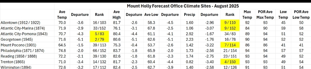
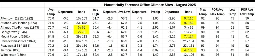
In addition, Islip ranked fourth and White Plains ranked 10th. -
gabby eats out sal, guaranteed
-
So far the wave is pretty far south, and to the north, and west is SAL.
-
High of only 77.2! Low of 53.0 this morning what a day
-

2025 Atlantic Hurricane Season
BarryStantonGBP replied to BarryStantonGBP's topic in Tropical Headquarters
-
It was wet in mid-august, but turned bone dry in September through October.
-
For August in a lot of locations in the NJ/PA/Deleware/Maryland area it was pretty cool and some places top 5 others top 20. Havent seen pretty much any posts about that from the typical stat heads. Very dry in the area as well.
- Today
-
My coldest August temp ever came in 1982 - got down to 38.8. I need to check the exact date. I believe there were Frost Advisories except for Lancaster and York counties.
-
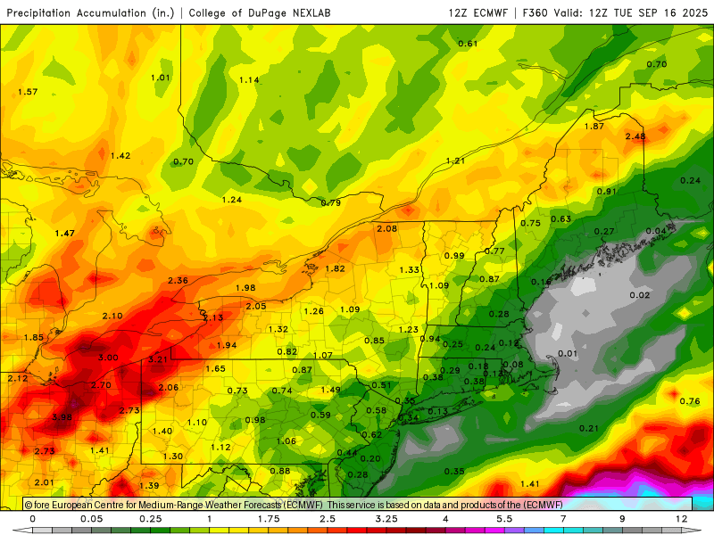
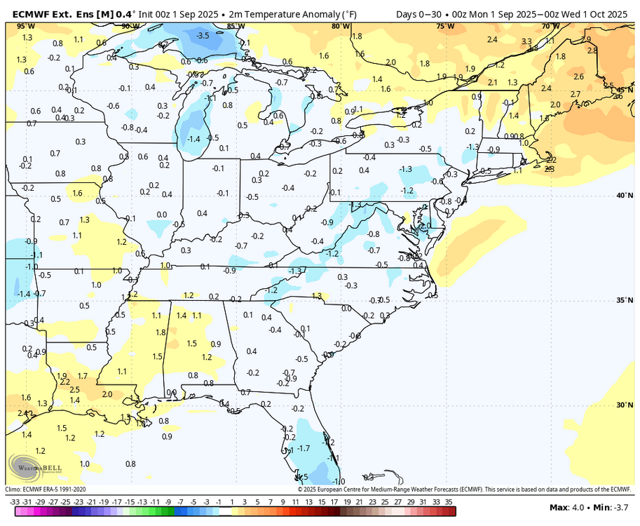
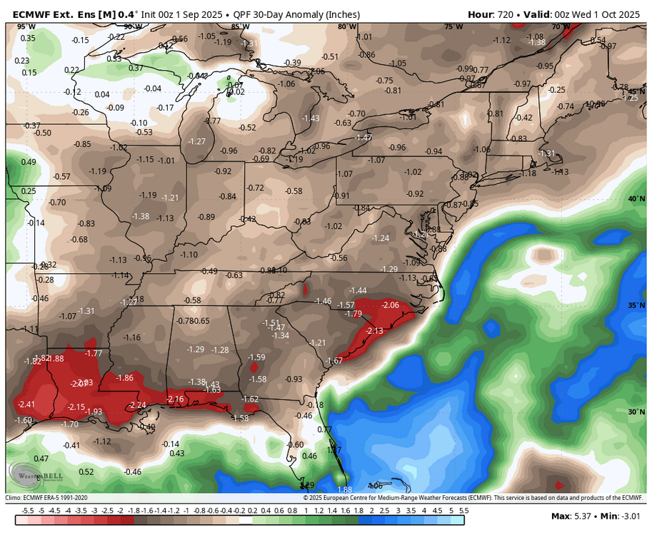
Latest WB EURO weeklies for September. Looks like more perfect fall weather, although we need rain.
-
I can see gabby become a recurve TBH Erin but slightly weaker I wonder why the euro picked out the CAG could be mixed in with fronts I reckon we could get b2b majors
-
Central & Eastern Pacific Thread
BarryStantonGBP replied to Windspeed's topic in Tropical Headquarters
kiko may pass near Hawaii -
Active Systems: The National Hurricane Center is issuing advisories on Tropical Storm Kiko, located in the east Pacific basin well west-southwest of the southern tip of the Baja California peninsula. Kiko is expected to cross into the central Pacific basin by the weekend. 1. South of Southwestern Mexico (EP94): Showers and thunderstorms associated with a tropical wave located less than 150 miles off the coast of southwestern Mexico are starting to become better organized, and recent satellite-derived wind data indicate that winds to 35 mph are present in the disturbance close to the coast of Mexico. This system is expected to become a tropical depression by the middle of the week. This system is expected to move west-northwestward to northwestward at 10 to 15 mph off the coast of southwestern Mexico during the next couple of days, then could turn northward and approach the Baja California peninsula later this week. Interests in the Baja California peninsula should monitor the progress of the disturbance, as watches or warnings could be required for portions of this area on Tuesday. Regardless of development, heavy rainfall is possible across coastal portions of southwestern and west-central Mexico today through mid-week. Heavy rainfall is also expected across Baja California Sur and northwestern Mexico Tuesday night through late this week. This heavy rainfall could lead to flash flooding, especially in mountainous areas. * Formation chance through 48 hours...high...80 percent. * Formation chance through 7 days...high...90 percent.
-
Ok Pete, reveal yourself…
-
Looks like last falls cold fronts . All of them failed east and south of the Mtns
-
The last couple of weeks have been very dry imby, but I got lucky with the 3” storm on the 31st of July and then another 1.01” for August, so it’s not entirely a dust bowl here. Yet.
-

2025 Spring/Summer Mountain Thread
Met1985 replied to Maggie Valley Steve's topic in Southeastern States
Had a high today of 69 and a current temp of 63. Gonna be a spectacular week of weather this week. -
The boats have been doing a lot of bumping and grinding with the low water.
-
Maybe I can do another 1/2” month.