All Activity
- Past hour
-
It seems like we have more deer than people here. I literally saw dozens today, mostly at Sunken Meadow, but a couple in my back yard. A new arrival here over the past 2 or 3 years has been skunks. Coyotes are next.
- Today
-
I've been a total deadbeat on the snow maps. Hopefully I'll get back on that project soon. I don't have my stuff right in front of me, but the 30-year average here is between 36 and 37". I think BNL is similar. Their 78-year average is 32": https://www.bnl.gov/weather/4cast/monthlysnowfall.htm
-

November 2025 general discussions and probable topic derailings ...
dendrite replied to Typhoon Tip's topic in New England
Yeah it’s just a color coded ptype algorithm. You can extrapolate from other dual pol products, but it’s easier for regular weenies to see. -
A prelude to the frigid arctic intrusions and wind driven snows of this upcoming winter particularly January & February. WX/PT
-
i remember once when living in NYC and the first sub 32 day was in early January. I used to run along the river on the UES and there were still rose bushes blooming after Christmas lol.
-
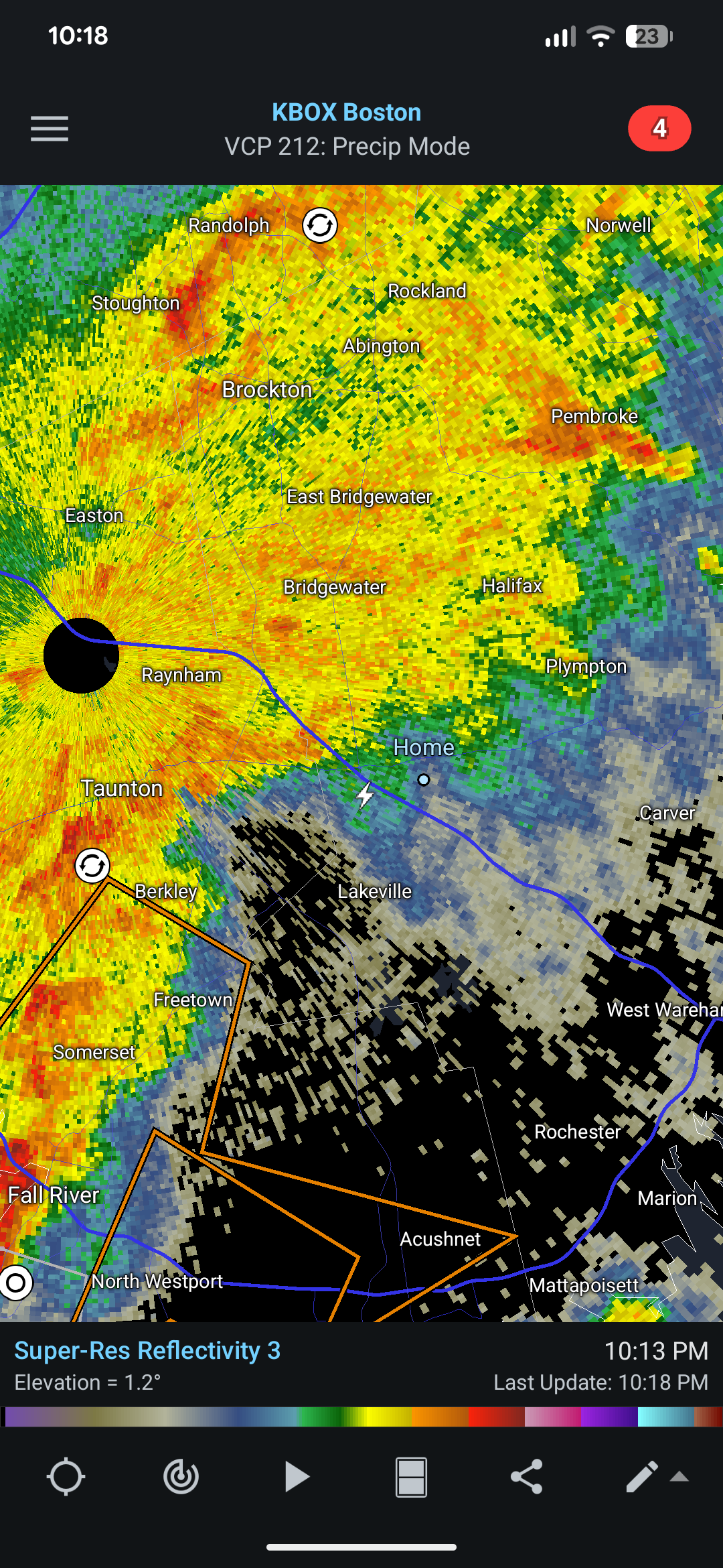
We actually had some very light rain! Lowlands continued to somehow score even a little bit in this pattern.
-

November 2025 general discussions and probable topic derailings ...
Torch Tiger replied to Typhoon Tip's topic in New England
Ok -
Watch DCA not freeze until like December 30th or something
-
Most likely reporting hail as snow. It's a dumb rule, but it's frozen so it count, IIRC.
-

Mid to long range discussion- 2025
WinstonSalemArlington replied to wncsnow's topic in Southeastern States
-
 Well that was pretty crazy for about 20 minutes. Had some sort of pingers mixed in at the beginning.
 -
Michael Lowry didn’t mention it, but the UKMET did even worse with Melissa than the GFS with it having her very weak on many runs early on, which then caused the model to keep it much further SW than the consensus including several runs of a weak TC into Nicaragua that I posted here. UKMET is such a hit or miss model. It absolutely shined for Imelda and both landfalls for Ian. What did its progs for Imelda and Ian have in common? It was the furthest to the RIGHT. What did its progs have in common for its big busts for Melissa, Laura, and some others? It was the furthest to the LEFT.
-

November 2025 general discussions and probable topic derailings ...
Bryan63 replied to Typhoon Tip's topic in New England
That came out of nowhere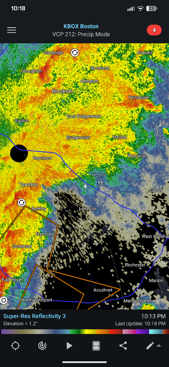
-

November 2025 general discussions and probable topic derailings ...
Roger Smith replied to Typhoon Tip's topic in New England
Quite the windstorm developing overnight to hit southeast Newfoundland (Avalon Pen) on Tuesday, winds could be near 150 km/hr in gusts. Low deepens to 945 mb as it approaches the Terra Nova area. I wonder if this is a sign of explosive development potential for lows later on in the approaching winter season in the general area? Then the next one along on Wednesday night develops rapidly off Nova Scotia and could bring 2-4" snowfalls to Atlantic Canada and eastern Maine towards conclusion of storm precip Thursday morning, but it looks like just a few wind blown flurries for New England otherwise, maybe scattered 0.5 to 1.0 inch snow over higher terrain .... are Lake Champlain snow squalls possible? ... there are some unusually cold air masses for this early showing up. -

2025 Atlantic Hurricane Season
Floydbuster replied to BarryStantonGBP's topic in Tropical Headquarters
The GFS continues to show a hurricane near Central America in the next 300 hrs. Likely more 992 mb than 892 mb though... -
I was just going back and looking through the snow totals by month and year for BWI, and I notice that the official records show a trace of snow in August of 2015 and June of 2016. Does anyone remember these? Seems like it has to be a mistake.
-

Central PA Fall Discussions and Obs
Itstrainingtime replied to ChescoWx's topic in Upstate New York/Pennsylvania
I am losing sleep waiting for your first snow map of the season. -

November 2025 general discussions and probable topic derailings ...
WinterWolf replied to Typhoon Tip's topic in New England
If/do we take the NAM at face value… -
 LOL, yeah, this is NOT my year. I have no issue in some form of a penalty, it just slipped my brain. Maybe it was because I was home! I remembered twice this year to get picks in before the date while away but being home, it just went *poof*.
 -
Love the Halal place by you
-
I have lost track of what late penalties I applied to whom in the past so, given the fact your position is identical to mine (hopelessly adrift of the leaders) I won't bother to penalize this one. If we keep going in 2026, I am going to have to bring late penalties up to date with current practices and expectations, what I said in the past was going to result in quite a few very large late penalties in 2025 but there are some forecasters here who are never late and they probably feel a bit put out by overly lenient policies too. The problem for me is, the contest is well supported by a loyal group but at the same time we have pretty close to the bare minimum number participating to make it worthwhile, and I am trying to balance the fairness aspect with the existence altogether of the contest. Anyway, same goes for StormchaserChuck who has not posted yet, he's in the chase-the-chase pack with you and me, it really doesn't matter much if we reduce our scores even further, any one of us could win November and December and still finish 700 points back of Tom and hudsonvalley21 and 300 back of the chase pack behind the leaders. I am just trying to stay clear of Normal at this point. General note -- all scoring updated and checked over, back in the thread before November forecasts.
-

November 2025 general discussions and probable topic derailings ...
CoastalWx replied to Typhoon Tip's topic in New England
Yeah Nam not enthused right now. -
Know all those areas very well. I live just NE of Rt 110 and Jericho Tpke intersection.
-
I’d be beyond thrilled with 30” here. My immediate part of LI is often close with coastal CT for snow. I’m thinking less especially if we get another zonked Pacific Jet dominated winter but hopefully we have some good opportunities come to reality.