All Activity
- Past hour
-
That's a general 3/4" to an inch or rainfall....I mean, what has happened to us when that isn't considered awful on a Saturday
-
36F here for the min. That was closer than I thought for the garden.
-
Same here...
-
Ha, I was just coming to post something similar. Hazy, milky summer skies in the 20th century were definitely due to pollution. Maybe there was occasional wildfire smoke but I don’t remember it. We have drastically improved air quality in the last 30 years, but now we get these smoky skies annually it seems. I know the last 3 years have been the worse for Canadian wildfires in modern history. I think there’s debate on how much wildfires are “normal” and what pre-colonization levels were.
-
https://www.facebook.com/photo?fbid=1286196370173602&set=a.477613334365247
-
From what I have read, some of it may have to do with Forest mismanagement in Canada. I'm sure there is more to it than that. Possibly the way Canada deals with the forest fires as well. It would be something interesting to look into further. In this morning's area forecast discussion, the Mount Holly office even states that more smoke will be evident today as it moves in from the north and west
-
Hopefully kids indoors and grilling just inside the garage this weekend in South Weymouth.
-
Looks like verrry subtly there's a tendency there to weaken the whole weekend morass too - maybe that'll continue and it'll deconstruct into just daily convection around a dying front. Sunday still looks good - seems to be the models are still spraying solutions wrt Saturday. The flow is weak/forcing is weak, so the model physics get more chaotic Before then ...looks like one of those 89.4/91/89.5 type of "heat wave". First truly elevated DPs though. Even if T's hold to the mid 80s a DP above 65, that is a circumstance no one in NE that hasn't traveled has experienced since last summer.
-

2025-2026 ENSO
PhiEaglesfan712 replied to 40/70 Benchmark's topic in Weather Forecasting and Discussion
That type of winter would almost certainly be a blowtorch winter in the Eastern US in today's warming climate. All you have to do is look at 2016-17, which was a similar-type winter to 98-99, and that torched in January and February. If not for March, this would have been a low-snow season in Philly and NYC. In places south of Philly, 16-17 was a Top 10 least snowy winter in Baltimore and DC. -
The most smoky day yet, the sky is entirely blotted out with the modest orange ball. Now instead of streaks of overcast we have this dreaded blight!
-
48 for my Marysville low today. I will miss this until it returns hopefully in September.
-
Let’s get 6z euro to flood Dendrite
-
Another chilly night, low was 40.5 degrees, close to a record but no cigar (38 in 1994). Currently up to 44.2/43.0 at 7:30 am. It was pretty hazy/smoky yesterday afternoon and evening but doesn't appear as bad this am.
-
Totally agree. Hopefully humidity will be low and won't be uncomfortable first thing in the morning.
-
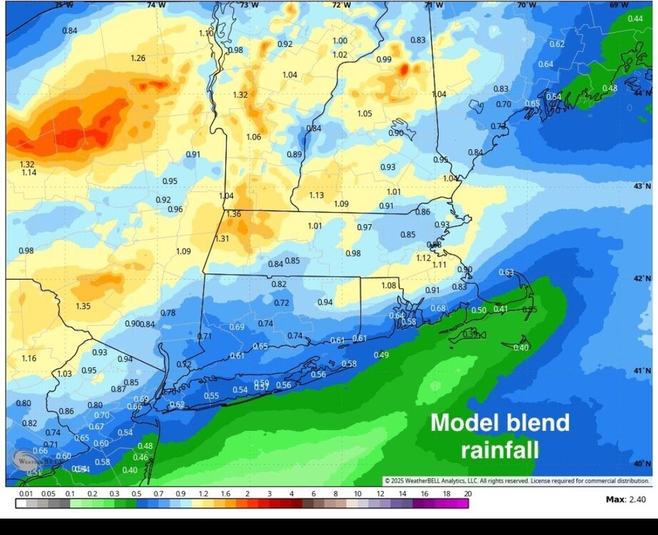
NBM blend wouldn't be awful for most. Not that we need more rain.
-
Very smoky rain this morning. AQI over 200, visibility under 3 miles. The smell of burnt boreal forest in the air.
-
Our first 2 days of June have featured temperatures almost 10 degrees below normal levels for the start of June. The good news is this should turn around starting today with temperatures reaching 80 degrees in some of the lower elevation spots across the area. By tomorrow through the rest of the work week we should all see temperatures in the low to mid 80's. Sunny skies most of the week before rain chances increase by Friday night into Saturday. We clear up but turn a bit cooler by Sunday.

-

E PA/NJ/DE Summer 2025 Obs/Discussion
ChescoWx replied to Hurricane Agnes's topic in Philadelphia Region
Our first 2 days of June have featured temperatures almost 10 degrees below normal levels for the start of June. The good news is this should turn around starting today with temperatures reaching 80 degrees in some of the lower elevation spots across the area. By tomorrow through the rest of the work week we should all see temperatures in the low to mid 80's. Sunny skies most of the week before rain chances increase by Friday night into Saturday. We clear up but turn a bit cooler by Sunday.
-
May toss the euro for down here but nervous.
-
Models have lows in the mid 70s Friday morning around NYC, I hope you're all happy! Nothing do I dread more than high minimums. I'd rather have mid 90s every day instead of lows near 80 at night.
-
I need a dry Saturday in Westchester. That's not looking likely is it?...
-
50 degree low here this morning
- Today
-
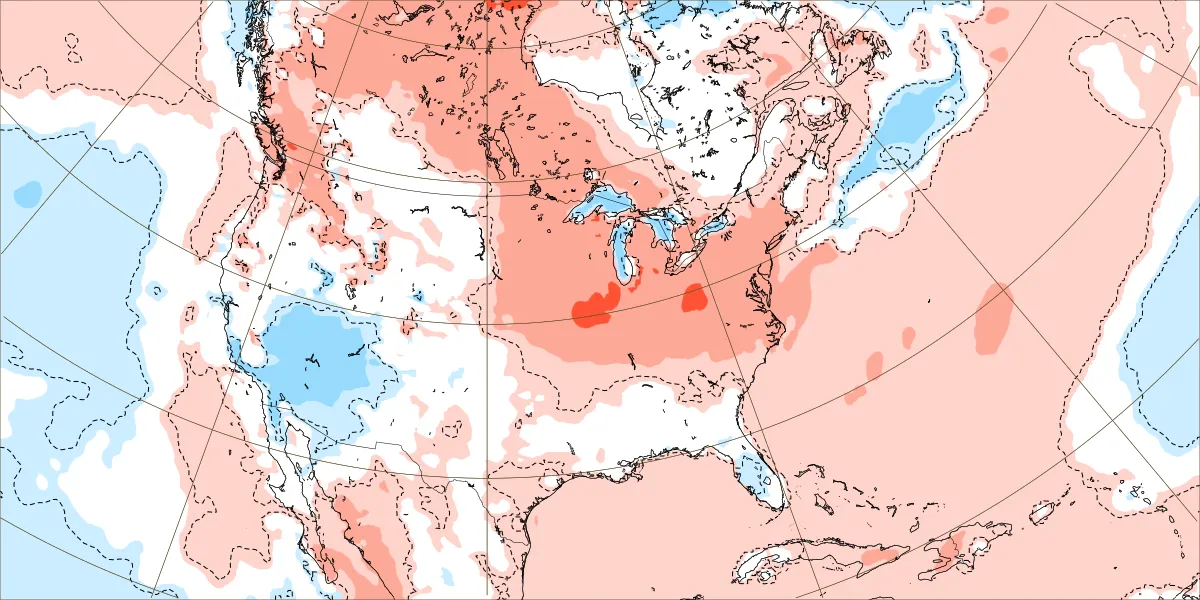
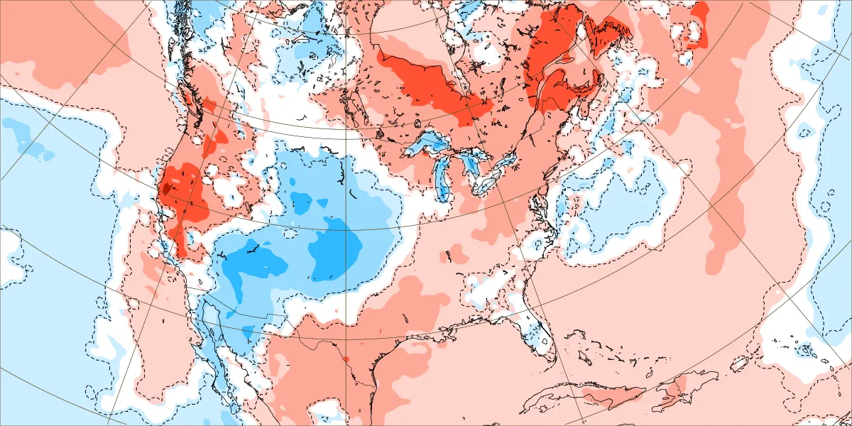
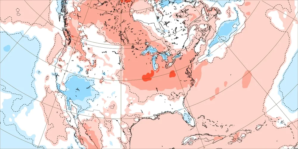
Yeah, the warm up this week turned into more of an over the top one than the models were showing last week. So the warmest departures will be up in Canada like we have been seeing so often. The usual warm spots will see their first 90° potential. But the onshore influence remains east of NYC. June 2 to 9 new run June 2 to 9 old run

-

2025-2026 ENSO
40/70 Benchmark replied to 40/70 Benchmark's topic in Weather Forecasting and Discussion
I agree with all of this. -
I don't remember this smoke from Canada ever in my 46 years of life. Maybe the haze in the 90's was smoke? I'm definitely not saying it's some conspiracy. I'd like to know why now and never before. Or was i just not noticing it years ago? Cloudy with thick smoke and 56