All Activity
- Past hour
-
That’s it, I’ve hit the wall. I’m letting whatever fell last night, freeze on the driveway tonight. It will melt soon enough.
-
I was living in the north end of BDR at the time. 6".
-

E PA/NJ/DE Spring 2026 Obs/Discussion
The Iceman replied to PhiEaglesfan712's topic in Philadelphia Region
Glad I didn’t book a tee time tomorrow last Monday. Would have been a cold one -
Can't disagree with this
-
Seems like our guy in Lunenberg has moved...
-
Concerning any potential last snow event around mid-month/St. Pat's Day...
-
Mid March slop storm for DC and points north on the Euro AI
-
A lot of the NE MA coops were around a foot of liquid that month. The Merrimack was raging by the end of it. Heavy heavy freshet. Fun month up here though.
-
Thats the Expedition. Monster sled. Frcst showing 8" here on weds. Looks like warmth is shlrt lived Sent from my SM-S921U using Tapatalk
-
OH I think the storm track's shifted N, frankly. I won't have hurt feelings if I turn out wrong there, but I have the equinox, climatology, and CC on my side here. Look at the sfc cinema on that run. It's one transit after the other down the 50th parallel of the continent. They'll drape strong cold fronts, sure. And probably some labored warm fronts ahead that drizzle at 34F. ...all keeping us from being "warm warm" like you're intimating, but I'm sort of leaning on the first step out being a coherent retreat of the storm track. We can still get a wintry event via anomaly relative to that, or bowling season related, etc.. but those are by def fleeting.
-
Yup..that was a JP of 8-9”’here…so it was a very good event. Gave a nice feel to December..And then the snow NYE and big squalls NYD. Was a good month.
-
Nice picture…looks like a Doo Comp 850 Turbo up on the bank there….place looks nice. Enjoy pal.
-
Good riding. Probably last ride. 33F in Eustis. Nice plate at Bald Mtn camps Sent from my SM-S921U using Tapatalk
-
It's such a tease looking at that. We're so close to the warmth but the heights are totally compressed up here. This isn't a good look either in the Southeast, especially Florida where I think they are in a pretty bad drought and there are major fire concerns. But that is also setting up to what could be an extremely active March in the Great Plains there. But for here...certainly going to be several wintry mix threats.
-
3/30
-
It's 67 and Sunny at work in central Spotsylvania County, and 53 and Overcast at home in Stafford County....... ETA: About 20-25 miles apart as crow files.
-
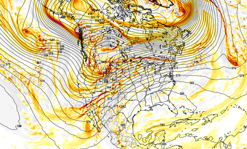
The last two days worth of GFS operational cycles have been doing this sort of look out there in the la-la range ... new leitmotif. I've found in the spring ( and autumn with cold looks, too - works in either direction), these longer range charts might actually carry some principle value, not daily or per se prognostic skill. Those are two different things. One's conceptualizing a synoptic potential at longer leads, the other is deterministic. Anyway, this next week's "failing" warm up was really exposed similarly to this above... when it too was a long lead. But idiosyncratics about the late winter/early spring hemisphere emerged to suppress, more so then corrected. In other words, I wonder it the lower latitude planetary wave distribution (which has longer residence ) is actually a warm HA - cool Baja - warm SW Atlantic basin... It would be sitting in wait for those "idiosyncractics" of late winter and early spring to pull away...
-
I'm with you too...we could be setting the stage for some early April heat. For as cold and chilly we have been here...there has been some anomalous warmth off to our southwest and it's not something that has been brief spurts either. Unless something major happened to kind of move away from this across the south, the only thing which has presented us from tapping into this has been the configuration in the Arctic. Relax that and we open the gates.
-
I’ll be in VA next week. Looking forward to the warm weather down there. We need next week’s thaw here desperately.
-

Occasional Thoughts on Climate Change
WolfStock1 replied to donsutherland1's topic in Climate Change
IMO trying to use/apply a single decade's worth of data is a fool's errand. There's too much background noise there in the ENSO and solar cycles. IMO anything meaningful with regards to changes in the rate of increase would need to be over at least a 20-year period, or even 30. That said "meaningful" here I equate with "strong evidence". 10-year data isn't totally meaningless - it's worth at least eyebrow-furrowing when it indicates something unusual. I just wouldn't use it to make a statement to the effect of "this shows that the rate of warming is increasing". -
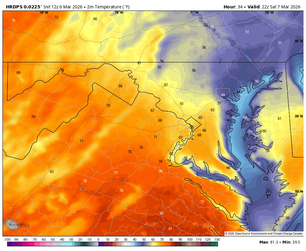
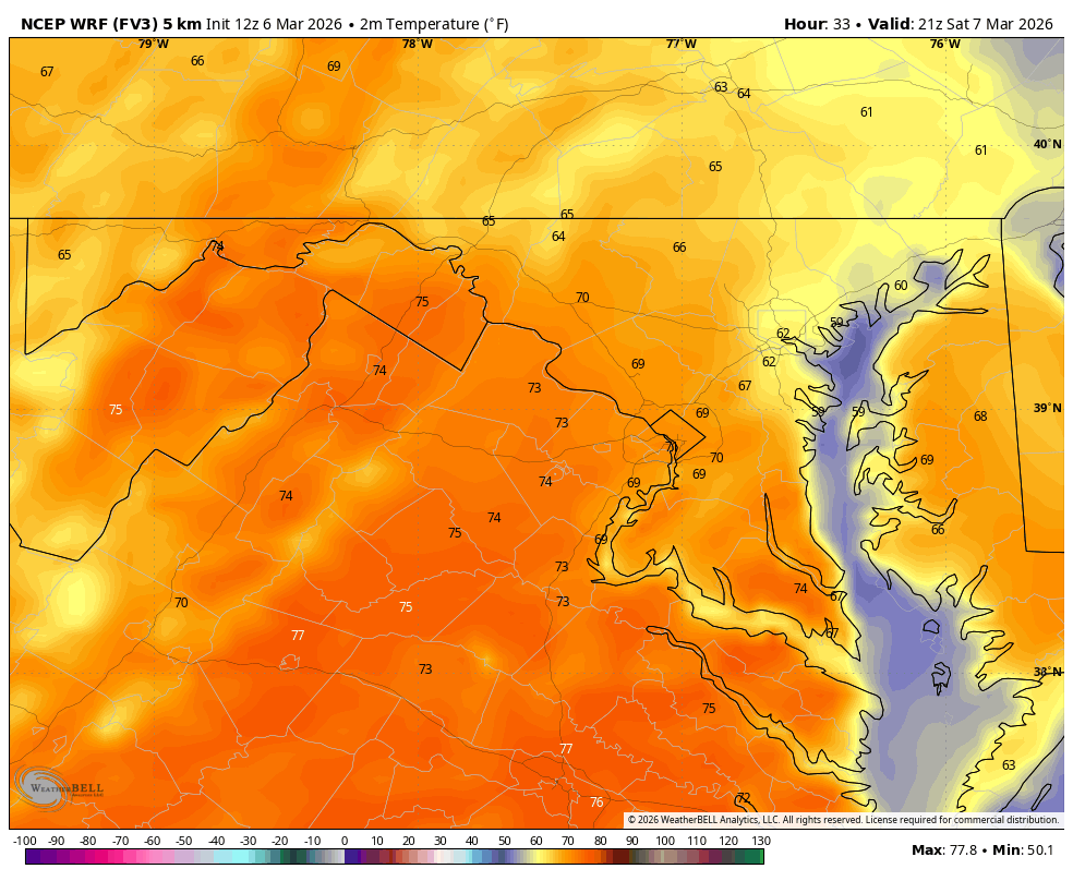
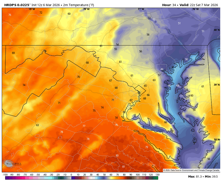
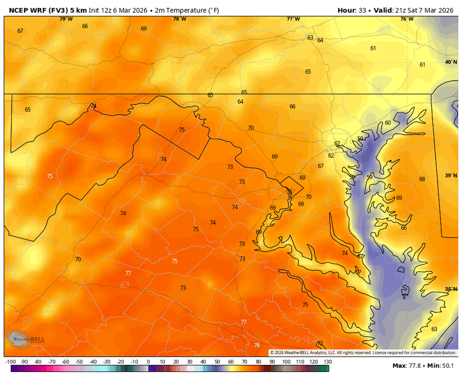
Canada gives us some good temps. WRF FV3 as well
- Today
-
Yep. Just the big dirt ice piles to look forward to. Probably take several days or more of 70s to get rid of those.
-
Interesting... I did not know you could do that. I will definitely look into this website more
-
I know what you're getting at... It's the difference between a well mixed warm sector with amorphous WCB trafficking strata and more DP related warmth. It's 64/57 below the warm front and E of the main b-c axis. That kind of warm up is impressive probably more so in the DP/ thermodynmaic quotient. The kinetic side of the temp is hugely above normal but not out of control in this kind of warm up. The other kind, the big dawg warming events that are more index correlated ... those are ridge dome deals with larger scale DVM compression through an unseasonably early 850 mb to surface kinetic layer. The actual thermodynamic quotient of the atmosphere is surprisingly low... 75/27 type thing... Moisten that air mass and it's 44 F beat the red head step child weather. Those kind of larger planetary wave things are related to the loss of polar index/mass field modulations on the mid latitudes, and when the air is dry and there's 850 mb anomalies rattling around in the ridge, the kinetic ceiling is high. Which by the way...either tends to proceed a -NAO burst. All that warmth then terminates at high latitude and there's a height growth up there.
-
Was able to get a measure of ice at 1/16" with the trees having a little more. Ugly stuff but picturesque. Lost power for a little more than a 1/2 hr, too, just a bit ago.
.thumb.png.4150b06c63a21f61052e47a612bf1818.png)