All Activity
- Past hour
-
Gfs much further north
-
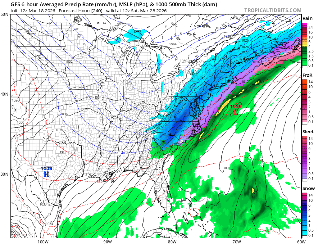
18Z DGEX!
-
 Final detailed report- Public Information Statement National Weather Service Mount Holly NJ 256 PM EDT Wed Mar 18 2026 ...NWS Damage Survey for 03/16/26 Tornado and Wind Damage Event... .Overview... On the evening of March 16, 2026 a narrow but intense line of storms along a strong cold front progressed through Delmarva, southeastern Pennsylvania, and New Jersey. Wind damage consistent with straight line winds of 60 to 70 mph was observed in many locations across the region. There were pockets of more intense damage listed below. The National Weather Service would like to thank our county emergency management partners for their help in our surveys. .Ridgely Maryland Tornado... Rating: EF-1 Estimated Peak Wind: 90-100 mph Path Length /statute/: 0.9 miles Path Width /maximum/: 250 yards Fatalities: 0 Injuries: 0 Start Date: March 16, 2026 Start Time: 10:26 PM EDT Start Location: 2.7 Miles SSE Ridgely / Caroline County / MD Start Lat/Lon: 38.9086 / -75.8742 End Date: March 16, 2026 End Time: 10:29 PM EDT End Location: 2.2 Miles SE Ridgely / Caroline County / MD End Lat/Lon: 38.9195 / -75.8641 Survey Summary: A narrow path of damage began shortly beyond the intersection of Route 404 and Holly Road and continued east towards the intersection of Holly Road and Central Avenue. The damage path began at two residences. One residence had minor roof damage. At the other residence, the roof of a barn was blown off along with all walls collapsed. Debris from the barn was thrown over a quarter mile away into open fields. There was a horse trailer that was thrown across the yard and flipped multiple times. Multiple windows on the first floor of the house were blown out. Significant tree damage was then observed beyond both of these properties as multiple large softwood trees were uprooted with large branches also snapped. Damage continued to the east with multiple large tree branches snapped in a more wooded area. Near the intersection with Central Avenue, the damage ended with multiple trees snapped or uprooted in this area marking the end of the damage path. .Frederica Delaware Tornado... Rating: EF-1 Estimated Peak Wind: 90-100 mph Path Length /statute/: 0.7 miles Path Width /maximum/: 75 yards Fatalities: 0 Injuries: 0 Start Date: March 16, 2026 Start Time: 10:48 PM EDT Start Location: 2.1 miles SSW Frederica / Kent County / DE Start Lat/Lon: 38.9841 / -75.4940 End Date: March 16, 2026 End Time: 10:49 PM EDT End Location: 1.9 miles S Frederica / Kent County / DE End Lat/Lon: 38.9833 / -75.4810 Survey Summary: Tree damage started at the intersection of Carpenter Bridge Road and Fork Landing Road, where multiple trees were uprooted and snapped. Tree damage continued eastward along Fork Landing Road, including multiple trees snapped. One snapped tree fell into a shed, destroying the shed. Tree damage was observed along Fork Landing Road until just before Browns Branch. .Ridgely Maryland Thunderstorm Wind... Peak Wind /E/: 80-90 mph Path Length /statute/: 0.22 miles Path Width /maximum/: 75 yards Fatalities: 0 Injuries: 0 Start Date: March 16, 2026 Start Time: 10:24 PM EDT Start Location: 2.4 miles SSW Ridgely / Caroline County / MD Start Lat/Lon: 38.9147 / -75.9027 End Date: March 16, 2026 End Time: 10:24 PM EDT End Location: 2.3 miles S Ridgely / Caroline County / MD End Lat/Lon: 38.9154 / -75.8987 Survey Summary: A brief area of significant wind damage occurred along Saathoff Road. The start of the path of wind damage involved the complete roof removal of a farm outbuilding with one wall collapsed inward. Metal roofing material was then scattered downstream to the east into an open field. Beyond the open field, there was some tree damage including one softwood tree snapped at the trunk. Additional damage beyond this tree line along Saathoff Road quickly lessened showing the end of the path of significant wind damage. This damage was separate but approximately 1.3 miles west of the starting point of the Ridgely tornado. .Millington Road Thunderstorm Wind... Peak Wind /E/: 80-90 mph Path Length /statute/: 1.9 miles Path Width /maximum/: 1 mile Fatalities: 0 Injuries: 0 Start Date: March 16, 2026 Start Time: 10:24 PM EDT Start Location: 1.8 miles NW Sudlersville / Queen Anne's / MD Start Lat/Lon: 39.2084 / -75.8807 End Date: March 16, 2026 End Time: 10:29 PM EDT End Location: 2.2 miles N Sudlersville / Queen Anne's / MD End Lat/Lon: 39.2192 / -75.8474 Survey Summary: Along Coleman Road, the start of significant wind damage occurred as multiple trees were uprooted and large tree branches were snapped. A farm outbuilding also experienced removal of metal roofing that was scattered to the east into an open field. As the swath of wind damage continued, there was additional farm outbuilding damage near Mud Ford Lane as the roof of an outbuilding was removed with the debris being scattered to the east up to half a mile away. It was at this point that the damage path width was at its widest, with about one mile from the damage on Coleman Road to the damage on Mud Ford Lane. The damage continued towards Millington Road where multiple power poles were snapped, large tree branches were snapped, and additional metal roofing was peeled off a farm outbuilding. Significant wind damage was estimated to have ended near Higman Mill Road as the last point of damage was metal roofing removed from another farm outbuilding. .Camden Delaware Thunderstorm Wind... Peak Wind /E/: 90-100 mph Path Length /statute/: 0.7 miles Path Width /maximum/: 400 yards Fatalities: 0 Injuries: 1 Start Date: March 16, 2026 Start Time: 10:39 PM EDT Start Location: 5.0 miles W Camden / Kent / DE Start Lat/Lon: 39.1107 / -75.6362 End Date: March 16, 2026 End Time: 10:40 PM EDT End Location: 4.3 miles W Camden / Kent / DE End Lat/Lon: 39.1133 / -75.6228 Survey Summary: Tree damage was first observed on Honeysuckle Road just south of the intersection with Westville Road. The highest degree of damage was noted near the intersection of Probst Lane and Westville Road. Several trees were snapped, including multiple trees that fell onto mobile homes. One injury was reported in this location. Sporadic tree damage was observed further east near and along Quail Run. Based on the debris direction, this was determined to be straight line wind damage.
 -
The finishing touches of a wall-to-wall cold and snowy winter. For those who love cold and snow, 1957-58 is one of the very few universal A+ seasons.
-
Too cold. Colder than I expected actually. Just got a bike ride in and needed a couple layers and gloves. I’m ready for summer.
-
Meanwhile it’s July, lawn drying up, pond so low it’s unveiling dugout canoes from the Wampanoags and I’m in the normal zone because of a surplus of rain in early April.
-
Once in awhile is ok. The reality is outside of the deals it isnt even inexpensive despite the crappiness. That Big Arch burger is 10 bucks typical price. I can go to a local place and get a quality double smash burger with hand cut fries for 16. The best thing they have hands down imo(only thing I ever want) is the sausage McMuffin with egg and cheese.
-
I think that was the year of the May 18 freeze. Summer got a really late start that year.
-
Crazy how we had more severe weather here in WNC than down east.
-

2025-2026 Fall/Winter Mountain Thread
Buckethead replied to Buckethead's topic in Southeastern States
GSP confirmed that we did have a tornado Monday morning in Madison County. Sent from my Pixel 10 Pro using Tapatalk -
.thumb.jpg.6a4895b2a43f87359e4e7d04a6fa0d14.jpg)
Central PA Spring 2026 Discussion/Obs Thread
Yardstickgozinya replied to Voyager's topic in Upstate New York/Pennsylvania
I'm pretty sure it brings me back to my days that a kid and the early years with my son catching frogs, turtles and tatpoles in the local wetlands. -
Central PA Spring 2026 Discussion/Obs Thread
Yardstickgozinya replied to Voyager's topic in Upstate New York/Pennsylvania
Call me crazy. While i've been cleaning up debris, at my clients ,I could smell one of my favorite spring smells. I just walk to the edge of the woods and I found it. YUMMY SKUNK.
-
This hurts. Rest in peace, weather friend.
-
18z NOGAPS
-
Probably will be a bit quite for a while...unless the GFS is to be believed

-
I try to stay away but the 6 dollar meal deal gets me sometimes on my hour and a half drive home from work haha
-
Remember, I'm ~45 miles in and at 700 feet so nights are cold. I think I undershot and therefore underbudgeted for the cold 3 months and with the pop in oil (and diesel) prices it's a bad time to be stuck buying enough for 6 cold weeks when I probably only need 30-50 more gallons.
-
…it’s the icon so does it even matter?
-
18z ICON
-
It would be the first solidly AN month for temps since September.
-
I hear ya on the maps though…we’ve made fun of them for a decade. Water pouring out of hillsides yet they paint everyone in D1.
- Today
-
I think he just knows in general how unhealthy that shit he peddles is. He banks on people being dumb enough to make it part of their regular diet, and so they have to suffer the health consequences. Capitalism at its worst.
-
Been busy all day. It’s happening. One more adventure guys. One more folks.
-
Yeah I know--it was just that line made me think the whole thing was a joke, lol I hope he recovers as well.
-
Alright, got some info from my supervisor...so first of all there were no weather observers here from Fall of 1996 to Spring of 2000. Any snowfall data from 2000 to 2012 is also not from CWO's but from the Air National Guard about a mile northeast of where we're situated now. When we were in Terminal B there was no place to measure snow accurately. He isn't sure if the data (assuming there is any) from 96-00 was also measured there since he didn't start working here til a little bit after obviously since there were no observers at all. One thing to keep in mind is that the measurements were often inaccurate. For instance, in the Halloween 2011 storm ANG measured 8" but my supervisor said it was more like 11 or 12"