All Activity
- Past hour
-
My latest freeze is May 31st (1984), so there is always a chance......
-
Just wait for that downsloping blowtorch in another month or so. Back to desert for you.
-
Showers have made it to DLH. Winds around the head of the Lake peaking 50-60+. Park Point & Duluth Harbor seeing the gusts of 60+. High wind warning issued today. 40+ up my way under wind adv.
-
haha this spring sucks. Might as well just skip summer this year
-

2025 Short Range Severe Weather Discussion
SchaumburgStormer replied to Chicago Storm's topic in Lakes/Ohio Valley
Nice little couplet in ford county working its way north -
Went to work in just shorts and my short sleeve shirt, no jacket. Was regretting the decision until about noon, then happy I made that choice.
-
nah... Don't let the gloom light of the day along with the negative temperature anomaly sway one's impression of May. It's quite a bit above normal this month, with several days near or even exceeding 80 F - so it wasn't just the lows this time ... With actually a lower cloud anomaly. This is no April. In fact, it's almost an insult to those that hate April for legitimacy to have to accept this month as being anything like what they've suffered all those wretched ass violating Aprils of the past. Lol clear enough?
-
It’s almost time for Tip’s annual nape post…for next year
-
Storm blew through earlier. Now it's sunny, hot and humid as all get out. Don't know if we are still in a favorable supercell environment or not. I assume so with the tornado watch.
-
Maybe slightly from a few days ago. Still looks like a general inch or so for much of the region with more in the higher terrain to the west, and any places that happen to get under some convection tomorrow.
- Today
-
I’ve heard some also — Brood XIV https://www.washingtonpost.com/nation/2025/04/24/cicadas-2025-brood-xiv-maryland-dc/?utm_campaign=wp_post_most&utm_medium=email&utm_source=newsletter&carta-url=https%3A%2F%2Fs2.washingtonpost.com%2Fcar-ln-tr%2F4242211%2F680bb3621e3c794918561e64%2F64fddbb854ee7d10a3e01f06%2F17%2F56%2F680bb3621e3c794918561e64 https://www.goodhousekeeping.com/life/a64795778/cicada-map/
-

2025-2026 ENSO
Stormchaserchuck1 replied to 40/70 Benchmark's topic in Weather Forecasting and Discussion
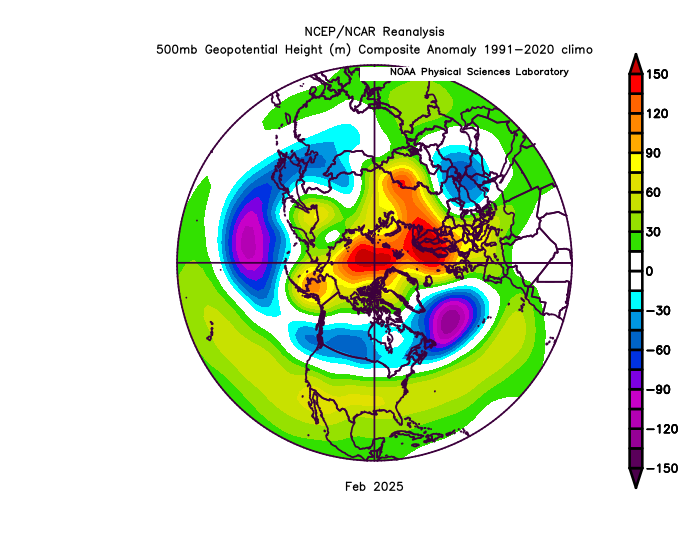
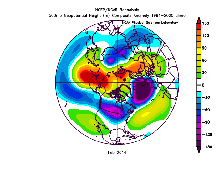
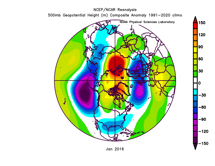
Importance of the +PNA for coastal low tracks bluewave Low's hug the coast in that pattern. CPC says it was +PNA, but the 500mb maps don't show that. We didn't have that piece in February. We had that piece in Feb 2016, and somewhat Feb 2014 (but it was much more -WPO in Feb 2014). WPO air temp correlation in Feb (opposite) - +200dm anomaly overpowered and kept Feb 2014 cold. +NAO was also further east - -200dm over England in Feb 2014. This one was closer to us. -
This is why our springs have gotten cooler (high temps) and a -nao has become prevalent in April and May while a +nao is prevalent in the winter now.
-
At least this will be gone before Memorial Day weekend. From the maps I've seen there may even be some sunshine tomorrow morning and the sun may come out again Friday afternoon.
-
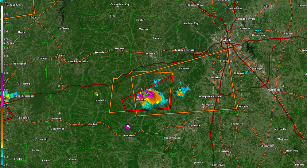
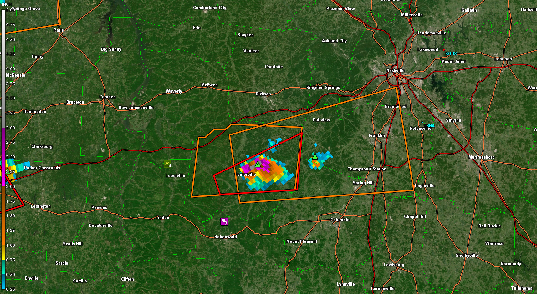
Some big hail ,the Centerville cell
-
38.3 here last night. Probably not done with the 30s quite yet this spring but glad it didn't go much below that. Spent several weekends planting recently and it would suuuuuck having to redo that.
-
2025-2026 ENSO
Stormchaserchuck1 replied to 40/70 Benchmark's topic in Weather Forecasting and Discussion
^I would say there was more +PNA, low pressure over the north Pacific in those two analogs. Feb 2014 looks like a pretty good N. Hemisphere 500mb match though. It takes about 6 days for a Pacific-PNA change to work its way to the SE ridge. We had a strong Aleutian High late Jan-early Feb. The south-based +NAO kept the SE ridge amped after that, without a major North Pacific trough present to cut it down. AO 50 degrees further north is not a big deal when there are strong anomalies closer, and the Pacific had a large part to do with the colder patterns in those 2 analogs. -
But similar patterns with great -AO blocks over 90N didn’t have any issues producing KU snowstorms in February 2014 and January 2016. So we can’t blame the +NAO either since the vortex near Iceland was much stronger those two months than this February. It comes back to the overpowering Northern Stream of the Pacific Jet which was much weaker in February 2014 and January 2016.
-
It'll be interesting to see how your actual vs. forecast verifies. I bust low/high (sometimes significantly) depending on the setup. Radiational cooling nights I always bust low. Sunny/dry I always bust high. What's the elevation of your cabin?
-
2025-2026 ENSO
Stormchaserchuck1 replied to 40/70 Benchmark's topic in Weather Forecasting and Discussion
Nice link! That -AO was completely over 90N, and the NAO was raging positive to the south of Greenland, putting a ridge over Europe and a SE ridge. I don't see that pattern as all that anomalous. When the AO first went negative, we had to have to some time to change the heavy Aleutian ridge that happened in Late January/early Feb. Remember how the Polar/mid-latitude Cell's work - a ridge centered over 90N puts a trough at 45N. And in the Atlantic at 45-50N was a massive low, since this one was closer it impacts us more. -5 AO's of the past had an arctic high pressure further south. -
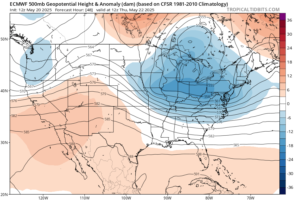
The big cutoff low which has become a familiar late May repeating pattern over the last 10 to 15 years.

-
Confirmed tornado moving through a very populated area near Jackson TN, though luckily it doesn't look particularly strong on radar.
-
Look like the event is trending drier for Wednesday into Thursday east of I-81?
-
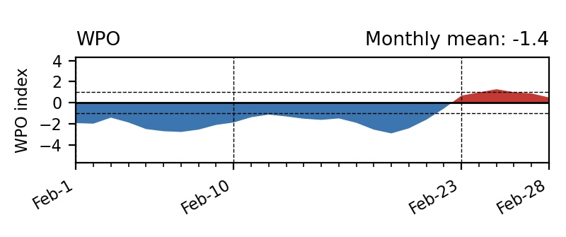
We can’t blame the WPO for last winter since there was a decent -WPO interval during the Feb 1 to Feb 21 with a solid block in the Bering Sea.This also coincided with a -5 daily -AO which reliably produced KU snowstorms in the past. Very difficult to pull off with such a powerful Northern Stream of the Pacific Jet which gave us a potent Great Lakes cutter at the some time the -AO was down near -5. So another Southeast Ridge link up with Greenland to Iceland blocking. https://www.ncei.noaa.gov/access/monitoring/monthly-report/synoptic/202502
-
We've really lost May as a summer month. Been replaced by April.


.thumb.JPG.418e8a9a2902ae687ec35ff4bc0e038e.JPG)