All Activity
- Past hour
-
We haven't had these in quite sometime lol
-

Is we back? February discussion thread
RUNNAWAYICEBERG replied to mahk_webstah's topic in New England
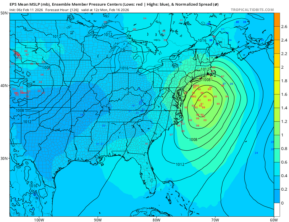
It would win back some of my trust since it threads the needle at h5 to bring this up the coast. Big kudos if it sniffs that out correctly at this lead time. -
3 questions need to be answered 1. Does the northern energy phase with the southern system. 2. How much cold air can this system generate along the I -95 Corridor based on the intensity and upward motion in the atmosphere. 3. Track of the storm
-
I doubt any warmups will long in the east due to the return of the negative WPO.
-
Wait? What happened? Lol Weirdos are the best. I love people that are passionate about stuff to the point they are just weirdos. A bunch of weather nerds coming together for a shitty thunderstorm sounds amazing lol
-

E PA/NJ/DE Winter 2025-26 Obs/Discussion
MickeyTim6533 replied to LVblizzard's topic in Philadelphia Region
thanks. still trying to learn things here. -
We’re/You’re gonna be fine. You in NB, me in Gaspe’ Quebec.
-
Record short term temperature rises in some spots as the cold pattern is finally relaxing.
-

Feb 10-11 Mid Week Minor Event - Ride the hot hand?
Prismshine Productions replied to HoarfrostHubb's topic in New England
3" last night so not too terrible Sent from my SM-S166V using Tapatalk -
There used to be a time when it was on an island by itself….it would win that game more often than not. Sadly, not any more. You have to be Very skeptical now. If it caves, it’s another Neil in the glue factory coffin for that model. If it wins…it’s a notch in its belt.
-
I hate the expression but this really is a thread the needle situation. Too far nw and we rain otherwise its a miss
-
2025-2026 New England Snow Recordkeeping Thread
Prismshine Productions replied to bristolri_wx's topic in New England
4" Fri/Sat 3" last night 47.6" on the season Sent from my SM-S166V using Tapatalk -

Central PA Winter 25/26 Discussion and Obs
pasnownut replied to MAG5035's topic in Upstate New York/Pennsylvania
Yessir. every year for as long as we can remember. Even as a weenie, when you do things long enough you get a feel for how things can (and often do) happen/evolve given certain parameters. Point is...to write something off at 6 days, well that's just silly, especially when there are no overwhelming signals one way or the other. Much atmospheric flux right now. -

Feb 10-11 Mid Week Minor Event - Ride the hot hand?
SouthCoastMA replied to HoarfrostHubb's topic in New England
10"+ of this stuff would bring down the grid. Love this type of snow -
Is we back? February discussion thread
RUNNAWAYICEBERG replied to mahk_webstah's topic in New England
I do but h5 doesn’t give me weenie feelings. Buyer beware… -
It was crunchy and ugly until, all of a sudden, the sun came out and *poof*, the melt begins. Up to 35° already and it feels awesome sitting here in the sun with the dog sprawled on the couch
-
6z eps with a shift NW
-
The two features on this 500 Vort map are still thousands of miles away - the northern stream Vorticity off the Aleutian Islands and the southern system entering the California coast and still need to be fully sampled. These 2 features are forecasted to phase by the Euro and create an intense storm off the mid-Atlantic coast trying to predict precip type and amounts this far out is impossible - also because of all the upward motion created by a phased system they create their own cold air supported by mariginal cold to begin with
-
Ugh I know…my heart swells when I see 60° temps in the forecast. Been hard to have an impactful snow away from the lakefront since early December. Feel like trends persist but I’m probably wrong. .
-

February 2026 Medium/ Long Range Discussion: 150K Salary Needed to Post
CAPE replied to Weather Will's topic in Mid Atlantic
More detailed discussion in the other thread including the 0z Canadian run. -
Schools are on a two hour delay. Ice everywhere. that should cement the snow on the ground for a bit
-
AI Euro keeps bumping north . You dont see the trend ?
-
Records: Highs: EWR: 66 (1960) NYC: 65 (2009) LGA: 63 (2009) JFK: 62 (2009) Low: EWR: -1 (1979) NYC: -2 (1899) LGA: 2 (1979) JFK: 3 (1962) Historical: 1895: The low temperature was 11 degrees below zero at Moline, Illinois, marking the last of 16 consecutive days on which the low temperature was at or below zero. During the first 11 days of February, Moline's highest temperature was only 13 degrees above zero. Their current average high temperature for early February is in the lower 30s. 1899 - Perhaps the greatest of all arctic outbreaks commenced on this date. The temperature plunged to 61 degrees below zero in Montana. At the same time a "Great Eastern Blizzard" left a blanket of snow from Georgia to New Hampshire. The state of Virginia took the brunt of the storm, with snowfall totals averaging 30 to 40 inches. (David Ludlum) 1983 - The Middle Atlantic Coast States and southern New England were in the midst of a major snowstorm. In Pennsylvania, the storm produced 21 inches at Philadelphia, 24 inches at Harrisburg, and 25 inches at Allentown, establishing record 24 hour totals and single storm totals for those locations. New York City received 22 inches of snow, and 35 inches was reported at Glen Gary, located in the Blue Ridge Mountains of West Virginia. Windsor Locks CT received a record 19 inches of snow in 12 hours. The storm resulted in forty-six deaths, thirty-three of which occurred when a freighter capsized and sank off the Maryland/Virginia coast. Heavy snow was reported from northeastern Georgia to eastern Maine. (10th-12th) (Storm Data) (The Weather Channel) 1983: Called the "Megalopolitan blockbuster snowstorm," this major snowstorm impacted the Mid-Atlantic and southern New England. Snowfall up to 25 inches fell at Allentown, Pennsylvania. Snowfall amount of 35 inches occurred in parts of the Blue Ridge Mountains of West Virginia at Glen Cary. Windsor Locks, Connecticut, recorded a record 19 inches in 12 hours. A ship sunk off the Virginia/Maryland coast, killing 33. There were 46 total storm-related fatalities. New 24-hour snowfall records were set in Philadelphia, Harrisburg, Allentown, Pennsylvania, and Hartford, Connecticut. Five inches of snow in one hour was recorded at Allentown and Hartford. 1987 - Denver, CO, reported only their third occurrence of record of a thunderstorm in February. Ten cities in the north central U.S. reported record high temperatures for the date. Huron SD reported February temperatures averaging 19 degrees above normal. Williston ND reported readings averaging 24 degrees above normal for the month. (The National Weather Summary) (Storm Data) 1988 - Bitter cold air gripped the north central U.S. Morning lows of 35 degrees below zero at Aberdeen SD, Bismarck ND and International Falls MN were records for the date. Bemidji MN was, officially, the cold spot in the nation with a low of 39 degrees below zero, however, a reading of 42 degrees below zero was reported at Gettysburg SD. In the Northern High Plains Region, Baker MT warmed from 27 degrees below zero to 40 above. (The National Weather Summary) 1989 - While much of the continental U.S. enjoyed sunshine and seasonable temperatures, a strong weather system over the Hawaiian Islands deluged Honolulu with 2.5 inches of rain. (The National Weather Summary) (Storm Data) 1990 - A winter storm produced up to ten inches of snow in Vermont, and up to nine inches of snow in Aroostook County of northeastern Maine. A three day snowstorm began to overspread Oregon, and the winter storm produced 29 inches of snow at Bennett Pass. Mild weather continued in the central U.S. La Crosse WI reported a record forty-seven consecutive days with temperatures above normal. (The National Weather Summary) (Storm Data) 1994: THE GREAT SLEET STORM OF FEBRUARY 10-11 1994 This winter storm was most unique in that produced almost entirely sleet for the immediate DC metro area. To the north, heavy snow fell and to the south and east, freezing rain occurred producing a devastating ice storm. In the Washington area, the sleet accumulation averaged between 3 to 4 inches. The maximum sleet accumulation occurred over Central and western Fairfax County, with over 4 inches of sleet measured at several locations. Only two other sleet storms in Washington's history have compared to this storm-one occurred in 1920 and the other in 1927. The average sleet depth for the 1927 storm was 4.5 inches. Washington was lucky it was sleet and not a glaze as they received south of DC. In areas to the south where the ice storm (glaze) occurred there were some areas without electricity for nearly a month and most had no power for a week. (p. 95-96 Washington Weather Book 2002 by Ambrose, Henry, Weiss) The Northeast was suffering under its 2nd winter storm in 3 days. Newark, NJ picked up 18 inches of snow on top of the foot that had fallen just a few days earlier. 18 inches fell at Newark, NJ & New Bedford and Hyannis, MA. 3 to 4 inches of sleet was reported at and around the Baltimore, MD – Washington, DC area.(Ref. Wilson Wx. History)Ref. (NWS Ranking for Storms between 1956 and 2011) This is the 17th Worst Snowstorm 1999: An F1 tornado did much damage to the ET Dunlap Center and nearby Kiamichi Tech Center in Idabel, Oklahoma. An instructor called in sick; the class was canceled; a damaged roof collapsed into the empty classroom. Good time for sickness! (Ref. Weather Guide Calendar with Phenomenal Weather Events 2011 Accord Pub. 2010, USA) 2004 - North Dakota Governor John Hoeven declares a snow emergency as winds gusting over 70 mph along with heavy snow produces low visibilities and drifts up to 20 feet in northwestern North Dakota. Amtrak train service is interrupted in the region. The Weather Doctor 2006 - Snowfall records fell in Philadelphia and Allentown, Pennsylvania, Bridgeport and Hartford, Connecticut, Newark, New Jersey, and Worchester and Boston, Massachusetts. The highest total reported was 30.2 inches at Fairfield, CT. New York City set a record one-day snowfall record of 26.9 inches in Central Park. 2010 The Nor'easter that blasted the region on February 10-11 was a true blizzard, with powerful winds that caused whiteout conditions. The 10 to 20 inches that smothered the urban areas from Washington, D.C. to Philadelphia, Pennsylvania, added to the deep snowpack already on the ground, resulting in depths (two-three feet plus) rarely if ever seen in this part of the country. Due to the amount of snow deposited on populated areas, this was also rated a Category 3 storm, the third since December. In addition, the new snowfall totals took the winter season numbers over the top, upsetting records established more than a century ago. Over 55 inches fell from December to February in Washington, D.C., while the northern suburbs picked up officially as much as 98 inches, including 55 inches in nine days—numbers that seasoned weather observers thought they would never see in their lifetimes. From Washington, D.C. to Philadelphia, Pennsylvania, and Atlantic City, New Jersey, this was not only the snowiest February on record, but the snowiest month ever. And, despite March being essentially snowless, Richmond, Virginia (28.0 inches); Washington, D.C. (56.1 inches at DCA and 73.2 inches at lAD); Baltimore, Maryland (77.0 inches); Philadelphia, Pennsylvania (78.7 inches); Wilmington, Delaware (72.7 inches); and Atlantic City, New Jersey (58.1 inches) all set records for the snowiest winter since modem recordkeeping began more than 130 years ago. (Ref. U.S. Weather Highlights of 2010 page 2 ) 2012: Thunder Snow with thunder heard at 1525 and 1526 and at 1528 during a snow squall. This was the first thunder snow we have observed at this station. (Records since August of 2008.) There was about a 3 to 5 minute period of snow pellets between 1506 and 1510. Heaviest snow was from 1525 to 1533 but some snow was melting as it fell as the temperature was above freezing during the even which started at 1505 and ended at 1545. The yard was becoming white around 1525 with snow and the deck is white and already covered but as hard as it snowing the street never became white as it was so warm. The low temperature during the snow was 34 °F and as soon as it was over it rose to 35 before falling again. This 0.5 inches was the most snow since January 25 and 26th of 2011 when 0.5 inches also occurred. (West Henrico Co. - Glen Allen Virginia Weather Center) 2013 :| The Hartford Courant Staff, The Hartford Courant on 2 - 12 - 2013 giving news from the 11th. As many businesses reopened after the weekend blizzard, snow-choked roadways in Hartford slowed the commute and caused traffic to backup onto highways. Traffic would have been worse but for the federal holiday that closed state government for the day. Hartford officials said snow clearing efforts continued Monday and Tuesday, but several main thoroughfares, including Asylum Avenue, were substantially restricted by snow that not yet been pushed off the street. People Go Back To Work After the Storm (Ref. The Hartford Courant)
-
AI Euro keep bumping north with every run
-
Yes its him


