All Activity
- Past hour
-
Just wild.
-
Before last Winter, PHL's lowest 7-year snowfall on record was 13.3"/yr. 2018-2025 was 10.5"/yr, a pretty big difference. They were the epicenter of the snow drought but I think had a near average season last year.
-
Sure is nice. 66/64. Nice cool breeze coming in through the window.
-
Looking like it's just gonna be some rain that should be long gone by daybreak instead of sustained overnight development, could be a rocking day
-
Perfect wx. Unfortunately EMA storm shield full effect through perhaps 6/20, however these days and nights are worth it!!
-
TIMING. Time the cold with the anomalous moisture associated with a super nino episode you have a brobdingnagian blizzard for DCA and the entire sub.
-
It may be Christmas in July all the way to December. As always … . .

-
I feel ya - on every point. The entire Austin Metropolitan Region is absolutely exploding with construction right now! Millions of tech people are flooding in and traffic is a catastrophe - every day. Even Sunday. You gotta keep on looking. Never presume drivers have common sense. Many of them are texting or sexting and gawd only knows what else these days! You gotta keep looking! People down here just love pulling right in front of other drivers, often with no signaling at all. It's getting ridiculous. And outright DANGEROUS. When you're not dodging rogue floods, you're dodging rogue drivers.
-
We’d take
-
May not have an EML but potential for steeper than usual lapse rates. This could be a significant wind event though if the strongest shear wasn’t lagging. With this said, given large CAPE and large dew point depression, there may be a nice swath of wind damage but with rapid weakening as the line enters western areas
-
Make no mistake about it. El Nino is ramping up. Right now, Midwest is getting soaked. Next week, at a time when the subtropical ridge should be established over south central Texas, yet ANOTHER storm cycle will be dumping even more torrential rains down on our communities. It will get worse. This is going to evolve into a super strength El Nino. They will not be calling the summer of '26 the Summer of 2026. They will be calling it the HARD RAIN of 2026. Autumn will be worse. Chillier than normal, with rain upon rain upon rain upon rain. Get used to lots of flood watches and warnings. Put your homes up on stilts. Better yet - Build an ARK. You're gonna need it! DO NOT HEAD FOR THE MOUNTAINS. That will be the worst place to be in this. Orographic precipitation enhancement will destroy many communities.. Man, this summer is beginning to read like a George BM intro to this thread every month. Oh wait, summer is still about eleven days away......
-
Middle of next week has potential.
- 156 replies
-
- 1
-

-
- we got burned
- rugpull central
- (and 1 more)
-

Central PA Summer 2026 Discussion/Obs Thread
mahantango#1 replied to Voyager's topic in Upstate New York/Pennsylvania
.14 rain today -
The PDO has been negative for years and we have still managed to snow. Most of those years have been Ninas(correlates to -PDO) so we shall see how it goes with a strong Nino. I would expect it to trend positive as we head into Fall.
-
Maxed out at 90.1 today at CEF. Have a shot at a 5 day heatwave unless clouds move in during the late morning / early afternoon to spoil things.
-
0.52" mostly from aftrn t-storm. Quite humid (72)
-
First night for me also, It’s a soupy night.
-
SA is very talented, but young. They aren't going anywhere. If the Knicks blow this their window to win a championship is probably closed. Now or never.
-
DVN gusted to 69mph earlier, MLI hit 55mph. The Kirksville area of northern/northeast MO is really getting trained this evening. Gonna be some huge totals overnight if that remains stalled out east/west through that area.
-
lol Knicks
- Today
-
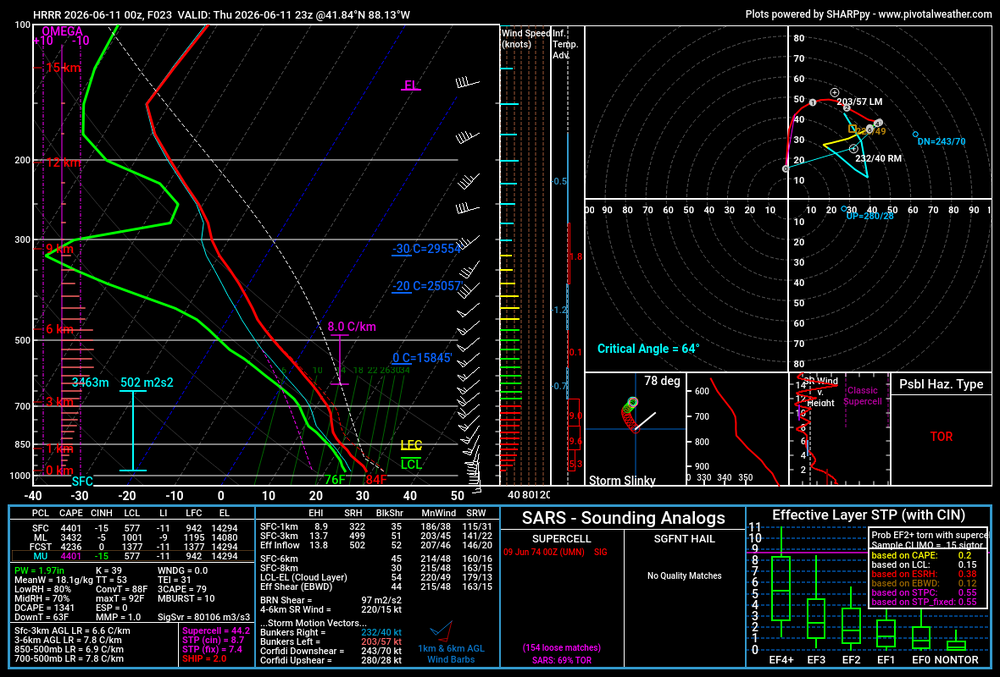
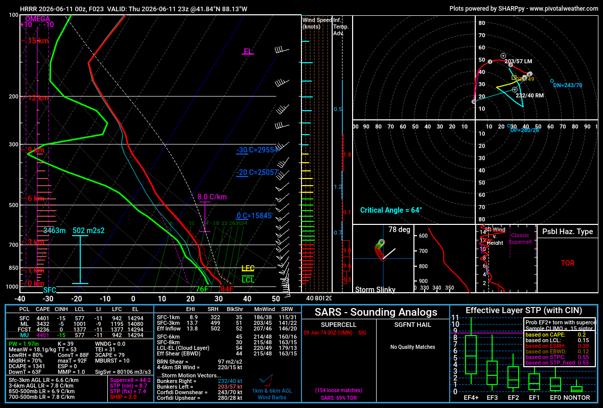
Todays HRRR modeled today’s convection pretty good and it has all of western lower MI under the gun tomorrow evening. The caveat is it’s Michigan. The strength of the low might have a lot more of influence. It’s more of a spring-like system with better wind fields than you typically see in the summer. Stronger mid-level westerlies may shunt the leftover debris east and keep mid-level lapse rates steep. But, it’s Michigan, so who knows.
-

Late May/June 2026 Medium/Long Range
Stormchaserchuck1 replied to JenkinsJinkies's topic in Mid Atlantic
Another severe wx pattern setting up, ahead of a strong trough- 156 replies
-
- 1
-
-
- we got burned
- rugpull central
- (and 1 more)
-

2026-2027 Super El Nino
BuffaloWeather replied to Stormchaserchuck1's topic in Weather Forecasting and Discussion
It only takes 1 storm to make a winter for the big cities and lake effect country. The rest of the area is screwed this upcoming winter. 15/16 was my lowest snowfall total year since I've been measuring here in Hamburg for the last 13. Right around 80" -
A/C is on tonight. 70/70 with fog and mist. Feels tropical out there.
-
0.43" Not bad. Need a lot more.


.thumb.gif.f92b16c631a1d15d405ed77b33f0710d.gif)