All Activity
- Past hour
-
Reminds me of yesterday's post by @MillvilleWx very muggy, moisture in the air and everything wet.
-
Showers on the shore...
-
There are a few stables around the area
-
One of our techs is there now, but I'm not hopeful for recovering it.
-
@OceanStWx Do you guys have the official high for CON from yesterday? I know the 93° was before the outage. If I had to put odds on the high estimate I think I’d go… 95° 50% 94° 40% 96° 10%
-
FWIW - HRRR has been awful at initializing the storms to the west.
-
Such is life in the rugged foothills of the The Highlands
-
Mesoscale Discussion 1145 NWS Storm Prediction Center Norman OK 1101 AM CDT Fri Jun 06 2025 Areas affected...Southern New England Concerning...Severe potential...Watch possible Valid 061601Z - 061800Z Probability of Watch Issuance...40 percent SUMMARY...Isolated wind damage and marginally severe hail will be possible with multicell storms after 18-19z (2-3p EDT) this afternoon. The need for a watch is uncertain. DISCUSSION...Strong surface heating is ongoing across southern New England along and south of a diffuse baroclinic/differential heating zone. As surface temperatures warm through the mid-upper 80s with mid-upper 60s dewpoints, MLCAPE will increase to near 2000 J/kg with minimal convective inhibition. By early-mid afternoon, widely scattered thunderstorm development will become probable along the diffuse baroclinic zone/buoyancy gradient. Steep low-level lapse rates, DCAPE of 750-1000 J/kg and precipitation loading could favor isolated wind damage with downbursts, while the moderately large buoyancy will be sufficient for marginally severe hail. Vertical shear will remain relatively weak and the storms are currently expected to remain only loosely organized, so the need for a watch this afternoon is uncertain. ..Thompson/Smith.. 06/06/2025
-
 Wobbling a bit!! No drop yet but fingers crossed...cmon fan aspiration!!!
-
Without CC all ridges were perfect and we never missed storms. Obviously joking, but that is the way it reads all the time.
-
I was riding a horse that was bucking. 87 here.
-
Here it comes... https://weather.cod.edu/satrad/nexrad/?parms=LWX-N0B-1-24-100-usa-rad
-
Predicting first "shot across the bow" in a couple of months.
-
85/67 now after a low of only 74. Hazy sunshine, but brighter than yesterday at this time.
-
WFH today and just realized that my temp is already 3 degrees above the forecast of 83. I'm sitting at 86 and it's confirmed here: https://www.wunderground.com/dashboard/pws/KPAMARIE28?fbclid=IwZXh0bgNhZW0CMTAAAR1aUZn05v6EL1SCu83D6YWAz4KB0xPA7zBHapk7ZxcoZfWMxfMgsX9YEUY_aem_AatgGdtB3HDmy_lQiEQW3p1bDKQzlUbvSccn8VpHsQ_8zcjQ2DxBPNU21ROdUrVrozfMvldDScho9lY6LgyGK0dL Looks like MDT is WAY behind what it is here.
-
Darkness has once again warshed over this dude.
-

2025-2026 ENSO
40/70 Benchmark replied to 40/70 Benchmark's topic in Weather Forecasting and Discussion
It was off the west coast when the storm took place, which is all that matters. Yes, the jet was a factor, but so isn't the poor positioning of the ridge. I don't know why you inexoprably seek agreement on a 100% CC attribution for everything. - Today
-
Going to be a HAIL-OF-A-DAY.
-
 also notice how your highs happen closer to 5/6 pm instead of the normal 3/4 pm. that's probably when the heavy shade starts to end
 -
If you're traveling on US RT 2, you'll get within a mile of my place, though it's 2 miles by road - from the blinker in New Sharon by Sandy River Farm Supply (one of the cheaper gas places in the area - $2.929 last I looked). Should be a nice ride up I-95, somewhat slower HUL to PQI. The pullout north from Medway has a great view of Katahdin, possibly compromised by smoke. (Maybe you've already been through there before and I'm not offering real news. )
-
Awesome stuff as always!!
-

2025 summer max contest -- enter by 06z June 23
NorthArlington101 replied to Roger Smith's topic in Mid Atlantic
#itneverhits100 DCA: 99 IAD: 99 BWI: 99 RIC: 99 -

2025 summer max contest -- enter by 06z June 23
Rhino16 replied to Roger Smith's topic in Mid Atlantic
DCA: 99 IAD: 99 BWI: 99 RIC: 101 -
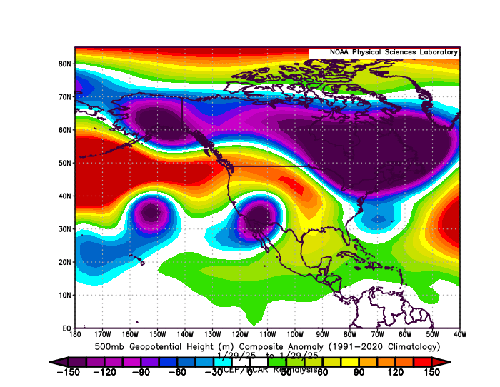
That ridge position in the means off the West Coast in January 2025 was able to build into the Rockies later in the month like you pointed out in 2022. But the Pacific Jet carving out a deeper Baja trough than we saw in 2022 was acting as a kicker. So the trough near the Northeast was a little too far east for a repeat of the late January 2022 blizzard. Too many competing marine heatwaves driving the pattern this past January to allow the pristine MJO 8 forcing pattern that we got back in 2022.
-
keep telling yourself it's that


