All Activity
- Past hour
-
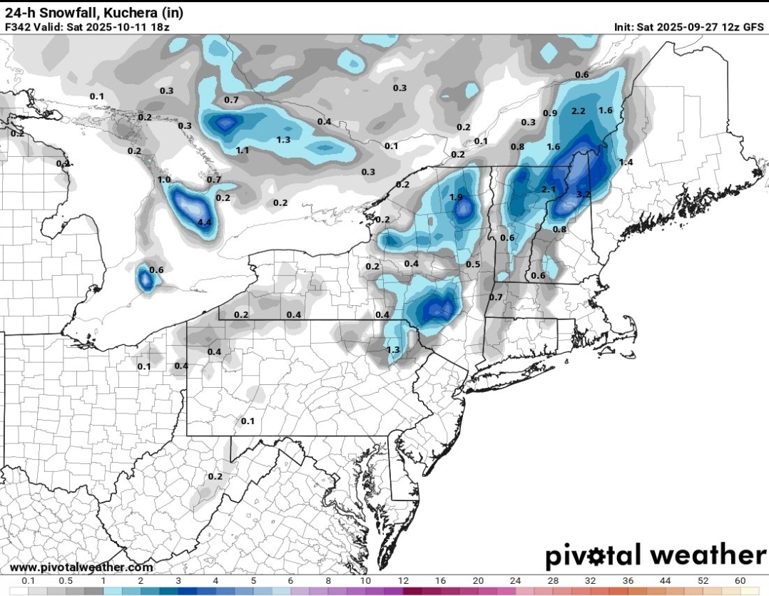
Glad I got that unexpected storm Wed night that produced an inch. No rain Thurs or Friday, when it was actually a pretty high probability. Tonight doesn't look great, despite the forecast for a half to three quarters overnight. 0.12" so far today.
-
What went wrong? We keep getting these "day of the event" fails...
-
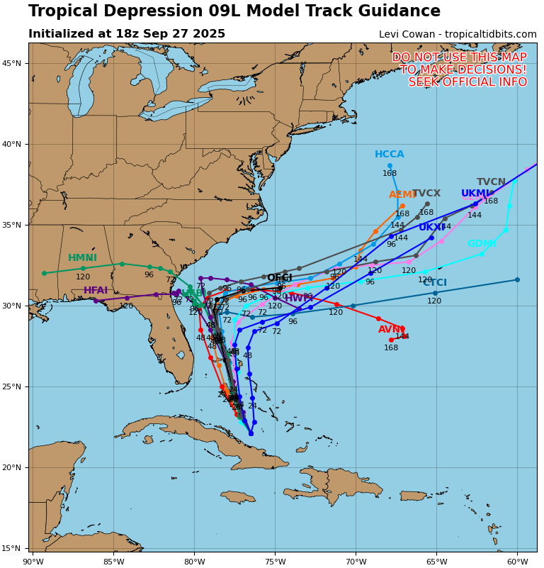
Tropical Depression Nine Discussion Number 5 NWS National Hurricane Center Miami FL AL092025 500 PM EDT Sat Sep 27 2025 The organization of the depression has not changed much since this morning. Some deep convection has flared up this afternoon near the estimated center, which appears broad in the 850-mb flight-level wind data from the Air Force Hurricane Hunters. The earlier scatterometer winds and more recent aircraft data do not suggest the system has intensified. The initial intensity is held at 30 kt for this advisory. The center appears to be slightly south and west of previous estimates, with an uncertain initial motion of 315/4 kt. Over the next couple of days, the system should turn more north-northwestward within the flow between an upper trough over the southeast U.S. and a subtropical ridge over the Atlantic. This forecast brings the depression over the central and northwestern Bahamas through early Monday, then toward the southeast U.S. coast by Tuesday. The NHC track forecast is very similar to the previous one, with only a slight nudge westward based on the initial position adjustments during the day. Warm waters and strong upper-level divergence should promote strengthening during the next few days, but this could be tempered by moderate southerly shear over the system from an upper-level trough. The NHC intensity forecast shows steady strengthening through early next week, with the system becoming a hurricane by 60 h. This prediction lies close to the latest IVCN and HCCA aids. There is still above-average uncertainty in the details of the long-range forecast. In general, the models agree that the presence of Hurricane Humberto to the east will result in a weakening of the prevailing steering currents, causing the system to slow down and meander near the southeast U.S. coast on Tuesday. While the chances of a landfall appear lower than yesterday, there are still some hurricane regional models and ensemble solutions that show this possibility. Given the expected asymmetric storm structure, a risk of significant heavy rainfall, storm surge, and wind impacts exists for the southeast U.S. coast even if the storm center remains offshore. The increased track spread at 96-120 h is related to whether the system feels the effects of an amplifying upper-level trough behind Humberto over the western Atlantic. While many global models show a sharp eastward turn and acceleration away from land, the system fails to be captured by the trough in the 12z ECMWF and lingers offshore. The NHC track forecast at days 4-5 maintains a consensus approach and shows a slower eastward motion, but future track adjustments are likely as confidence increases. The system may be in close proximity to fronts by the end of the period, so extratropical transition could begin around or shortly after day 5. KEY MESSAGES: 1. The depression is expected to strengthen and bring tropical storm conditions to portions of the central and northwestern Bahamas through Sunday night. Tropical storm conditions are also possible along portions of the east coast of central Florida beginning Monday, where a Tropical Storm Watch is in effect. 2. Rainfall will continue to impact eastern Cuba, Hispaniola, Jamaica, and the Bahamas through the weekend, which will likely produce flash and urban flooding. Mudslides are possible in the higher terrain. 3. There is a significant threat of heavy rainfall early next week from portions of the east coast of Florida northward into the Carolinas, which could cause flash, urban, and river flooding. 4. The depression is expected to be at or near hurricane intensity when it is closest to the southeast U.S. coast early next week, where there is a risk of storm surge and wind impacts. Although it is too soon to specify the exact location and magnitude of impacts, residents should closely monitor the latest forecast updates and ensure that they have their hurricane plan in place. FORECAST POSITIONS AND MAX WINDS INIT 27/2100Z 22.2N 76.5W 30 KT 35 MPH 12H 28/0600Z 23.3N 77.1W 35 KT 40 MPH 24H 28/1800Z 24.9N 77.6W 45 KT 50 MPH 36H 29/0600Z 26.7N 78.1W 55 KT 65 MPH 48H 29/1800Z 28.5N 78.6W 60 KT 70 MPH 60H 30/0600Z 30.0N 78.8W 65 KT 75 MPH 72H 30/1800Z 30.8N 78.6W 65 KT 75 MPH 96H 01/1800Z 31.1N 76.8W 65 KT 75 MPH 120H 02/1800Z 31.5N 74.0W 60 KT 70 MPH $$ Forecaster Reinhart
-
there's no rain. it's been drizzle every now and then but i doubt it adds up to any more than 0.1 inches
-
-
This is a disaster. Right back to drought.
-
That must be mostly Siberia I would think. But, still good.
-

September 2025 OBS-Discussion centered NYC subforum
donsutherland1 replied to wdrag's topic in New York City Metro
Islip reached 82° today. That was its fifth 80° or above high during the second half of September. The last time there were at least as many such days during the second half of September was in 2017 when there were eight such days. The five days is also tied with 1998 and 2016 for the fifth highest number on record for the second half of September. -
-
Just snow.

-

Spooky Season (October Disco Thread)
HoarfrostHubb replied to Prismshine Productions's topic in New England
A bit of a mild down on the 1st and 2nd. GFS is teasing us. -
Humberto C5 Second of the year.
-
Moderate rain down here in Calvert now.
-
000 WTNT43 KNHC 272044 TCDAT3 Hurricane Humberto Discussion Number 13 NWS National Hurricane Center Miami FL AL082025 500 PM AST Sat Sep 27 2025 Humberto has quickly strengthened during the past several hours. A very symmetric ring of cloud tops colder than -70 deg C now surrounds the clear eye of the hurricane. At 1800 UTC, the TAFB subjective Dvorak analysis was 7.0/140 kt. Most of the objective techniques like the UW-CIMSS ADT and AIDT, as well as the SAB subjective Dvorak fix supported a slightly lower intensity, closer to 130 kt. However, since that time, cloud tops around Humberto have gotten colder and the objective estimates have increased. Therefore, the intensity has been set at 140 kt, making Humberto the second category 5 hurricane of the 2025 Atlantic hurricane season. Some additional strengthening is possible tonight. Internal factors like eyewall replacement cycles will likely dominate Humberto's intensity for the next day or two, so fluctuations in maximum wind speeds are expected. All of the intensity guidance indicates that some slow weakening is expected to begin by Monday, before Humberto begins to interact with a mid-latitude trough on Tuesday. The cyclone should then begin its extratropical transition shortly thereafter, resulting in a quicker decrease in maximum winds but an expansion of the overall wind field. Overall, little change was needed to the official forecast aside from showing a higher intensity for the first day or two. Only a slight westward adjustment was made to the track forecast. Humberto is moving slightly faster, but westward, near 9 kt. The hurricane is still forecast to move around the subtropical ridge for the next few days before it interacts with the aforementioned trough and accelerates quickly northeastward. The spread in the model track guidance has increased since the last advisory, particularly with regard to how fast Humberto will accelerate northeastward in 4 or 5 days. Confidence in that aspect of the forecast has therefore decreased, even though little change was made to the official forecast. The NHC forecast remains generally based on a blend of the GDMI, the AIGEFS and HCCA. FORECAST POSITIONS AND MAX WINDS INIT 27/2100Z 22.9N 61.1W 140 KT 160 MPH 12H 28/0600Z 23.5N 62.7W 145 KT 165 MPH 24H 28/1800Z 24.7N 64.6W 140 KT 160 MPH 36H 29/0600Z 26.2N 66.1W 135 KT 155 MPH 48H 29/1800Z 28.0N 67.5W 125 KT 145 MPH 60H 30/0600Z 30.0N 68.5W 115 KT 130 MPH 72H 30/1800Z 32.1N 68.5W 105 KT 120 MPH 96H 01/1800Z 36.1N 62.4W 95 KT 110 MPH 120H 02/1800Z 42.5N 46.5W 85 KT 100 MPH...POST-TROP/EXTRATROP $$ Forecaster D. Zelinsky/Bookbinder
-
BULLETIN Hurricane Humberto Advisory Number 13 NWS National Hurricane Center Miami FL AL082025 500 PM AST Sat Sep 27 2025 ...HUMBERTO QUICKLY STRENGTHENS TO A CATEGORY 5 HURRICANE... SUMMARY OF 500 PM AST...2100 UTC...INFORMATION ---------------------------------------------- LOCATION...22.9N 61.1W ABOUT 350 MI...560 KM NNE OF THE NORTHERN LEEWARD ISLANDS ABOUT 685 MI...1105 KM SSE OF BERMUDA MAXIMUM SUSTAINED WINDS...160 MPH...260 KM/H PRESENT MOVEMENT...WNW OR 285 DEGREES AT 10 MPH...17 KM/H MINIMUM CENTRAL PRESSURE...925 MB...27.32 INCHES WATCHES AND WARNINGS -------------------- There are no coastal watches or warnings in effect. Interests in Bermuda should monitor the progress of Humberto. DISCUSSION AND OUTLOOK ---------------------- At 500 PM AST (2100 UTC), the center of Hurricane Humberto was located near latitude 22.9 North, longitude 61.1 West. Humberto is moving toward the west-northwest near 10 mph (17 km/h). A turn toward the northwest is anticipated on Sunday. Humberto is forecast to then turn northward and move west of Bermuda by Tuesday evening. Maximum sustained winds have increased to near 160 mph (260 km/h) with higher gusts. Humberto is now a category 5 hurricane on the Saffir-Simpson Hurricane Wind Scale. Humberto will likely remain a powerful major hurricane for the next several days. Hurricane-force winds extend outward up to 25 miles (35 km) from the center and tropical-storm-force winds extend outward up to 125 miles (205 km). The estimated minimum central pressure is 925 mb (27.32 inches). HAZARDS AFFECTING LAND ---------------------- SURF: Swells generated by Humberto will affect portions of the northern Leeward Islands, the Virgin Islands, Puerto Rico, and Bermuda beginning tonight and continuing through next week. Swells from Humberto will also affect the U.S. East Coast beginning Monday. These swells are likely to cause life-threatening surf and rip current conditions. Please consult products from your local weather office. NEXT ADVISORY ------------- Next complete advisory at 1100 PM AST. $$ Forecaster Bookbinder/D. Zelinsky
-
since there's no threat, haven't really been tracking.
-
The curve to north near end of run Are increasing.

-

Category Five Hurricane Humberto
Boston Bulldog replied to WxWatcher007's topic in Tropical Headquarters
As expected, we have our second cat 5 of the season. Really hope we can get recon in there before the next EWRC - Today
-

2025-2026 ENSO
so_whats_happening replied to 40/70 Benchmark's topic in Weather Forecasting and Discussion
.thumb.gif.fb67b3bc1f0ba6f1ccc4eef60d7842a0.gif)
-
Cat 5 Humberto 160 mph
-
Got slammed today. 1.08 and still light rain. Looks like we are going to be fortunate to not get much if any rain from Imelda. Dry and seasonal the next few weeks
-

Category Five Hurricane Humberto
hawkeye_wx replied to WxWatcher007's topic in Tropical Headquarters
The T# is up to 7.0, which is 160 mph. This certainly looks near cat 5. -
September 2025 OBS-Discussion centered NYC subforum
donsutherland1 replied to wdrag's topic in New York City Metro
As of 4:30 pm, some showers were working their way into southern New Jersey. Cape May was receiving light rain. Some of these showers could each the New York City area tonight. Showers and light rain are possible tonight into tomorrow. Rainfall amounts should be light. Above normal temperatures will continue through the remainder of September. The start of October could see the arrival of the coolest air mass so far this season, but temperatures will likely quickly moderate. The guidance and historical experience following a second half September mean temperature of 70° or above suggest that October will be warmer than normal in the New York City area. The two most recent Octobers with a cooler than normal first half like 2025 and a second half with a mean temperature of 70° or above were: 2017 (October mean temperature: 64.1° and October 2019: October mean temperature 59.9°). The probability that TD9 will approach the South Carolina coast but then turn out to sea from there is increasing on account of the expected Fujiwhara interaction with the stronger Humberto. That is now the most likely outcome, even as there remains a possibility of landfall. Even without landfall, the storm would bring periods of heavy rain, gusty winds, and pounding surf to coastal areas. The ENSO Region 1+2 anomaly was 0.0°C and the Region 3.4 anomaly was -0.4°C for the week centered around September 17. For the past six weeks, the ENSO Region 1+2 anomaly has averaged -0.03°C and the ENSO Region 3.4 anomaly has averaged -0.38°C. La Niña conditions will likely develop during mid- or late-autumn. The SOI was +2.85 today. The preliminary Arctic Oscillation (AO) was +0.807 today. Based on sensitivity analysis applied to the latest guidance, there is an implied near 99% probability that New York City will have a warmer than normal September (1991-2020 normal). September will likely finish with a mean temperature near 70.3° (1.1° above normal). Supplemental Information: The projected mean would be 2.3° above the 1981-2010 normal monthly value. -
Doesn’t look like rain anywhere next 2 weeks
-
Yes, Capatain made comment about the Natives using it for arrowheads, axes, etc Sent from my SM-S921U using Tapatalk


.gif.175331d3b935c9014d5e48c621e5e4f4.gif)


