All Activity
- Past hour
-
Torch!!
-
The eastern half of NC could get some heavy, beneficial rainfall over the next couple days depending on how strong the coastal low gets.
-
AIFS ensemble not as warm, but same theme. AN.
-
Blood red on the EPS. Wow. Zero signs of Fall.
-

2025 Lawns & Gardens Thread. Making Lawns Great Again
Brewbeer replied to Damage In Tolland's topic in New England
I'll be mowing mine after the dew dries -
Torch!
-
For JFK December was warm and wet finishing +0.9° with 4.44” of precipitation. January was near normal and dry at +0.2 and only 0.65” of precipitation. February was warm and wet finishing at +2.7 and 3.17” of precipitation.
-
Thanks, I love my South Minneapolis neighborhood. The home with the wreath on the front door is an Airbnb, directly across the street from us.
-
The time has come to admit that this is not going to be a hyperactive (ACE/named storms) Atlantic tropical season. The ship has sailed folks
-

September 2025 OBS-Discussion centered NYC subforum
bluewave replied to wdrag's topic in New York City Metro
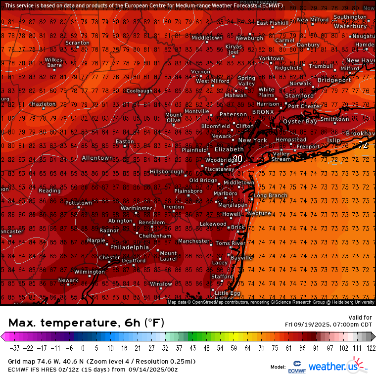
Even JFK has a shot at 85-90° next Friday as the models have a warm downslope flow now.
- Today
-
53/51 another GSD day.
-

2025 Lawns & Gardens Thread. Making Lawns Great Again
BrianW replied to Damage In Tolland's topic in New England
Nothing better than an Octoberfest and some fall mowing...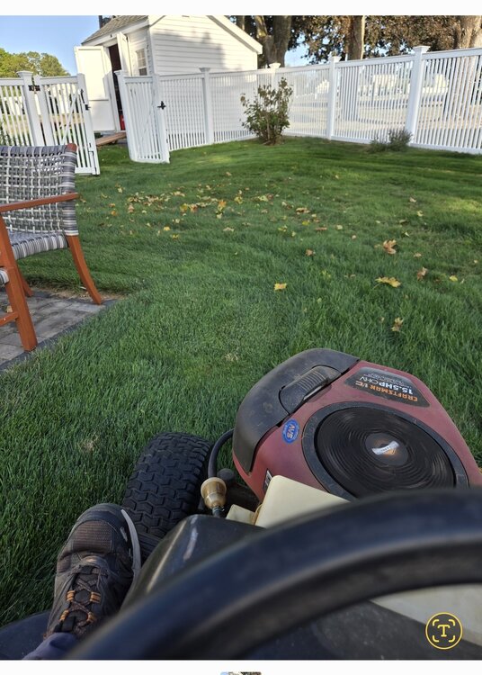
-
WPC beefing up rainfall totals with latest update.
-
I was surprised my high was 87 yesterday, welcome back summer.
-
Looks like the Niña/-IOD standing wave has set up
-

Fall/Winter Banter - Football, Basketball, Snowball?
John1122 replied to John1122's topic in Tennessee Valley
That was a tough loss. We've not had such a painful FG miss since 2010 vs Alabama, and that one was blocked. Team looked better than I expected on offense, but man, gotta make that kick. -
Looks brutal this week.. Detailed Forecast Overnight Patchy fog after 5am. Otherwise, partly cloudy, with a low around 53. Calm wind. Sunday Patchy fog before 7am. Otherwise, mostly sunny, with a high near 76. Calm wind becoming northwest around 6 mph in the afternoon. Sunday Night Mostly clear, with a low around 51. Calm wind. Monday Sunny, with a high near 76. Light northeast wind. Monday Night Mostly clear, with a low around 50. Light and variable wind. Tuesday Sunny, with a high near 76. Light and variable wind. Tuesday Night Mostly clear, with a low around 50. Calm wind. Wednesday Mostly sunny, with a high near 76. Calm wind becoming southwest around 5 mph in the afternoon. Wednesday Night Mostly cloudy, with a low around 52. Calm wind. Thursday Partly sunny, with a high near 77. Calm wind becoming southwest around 6 mph in the afternoon. Thursday Night Partly cloudy, with a low around 55. Light south wind. Friday Sunny, with a high near 78. Northwest wind 5 to 8 mph. Friday Night Mostly clear, with a low around 48. North wind around 6 mph. Saturday Mostly sunny, with a high near 67. North wind around 7 mph.
-
For 60% orange in MDR 0Z UKMET: TS in middle of ocean again NEW TROPICAL CYCLONE FORECAST TO DEVELOP AFTER 96 HOURS FORECAST POSITION AT T+ 96 : 16.4N 45.5W LEAD CENTRAL MAXIMUM WIND VERIFYING TIME TIME POSITION PRESSURE (MB) SPEED (KNOTS) -------------- ---- -------- ------------- ------------- 1200UTC 17.09.2025 96 16.4N 45.5W 1005 41 0000UTC 18.09.2025 108 17.6N 47.7W 1005 45 1200UTC 18.09.2025 120 19.7N 49.9W 1006 44 0000UTC 19.09.2025 132 20.6N 51.6W 1006 40 1200UTC 19.09.2025 144 21.4N 53.0W 1005 36 0000UTC 20.09.2025 156 22.5N 53.5W 1004 46 1200UTC 20.09.2025 168 22.9N 55.4W 1002 45
-
That’s a pretty low bar
-
It should be a more exciting winter for most of SNE than last winter.
-

September 2025 OBS-Discussion centered NYC subforum
psv88 replied to wdrag's topic in New York City Metro
77 today. Light showers now -

2025-2026 ENSO
40/70 Benchmark replied to 40/70 Benchmark's topic in Weather Forecasting and Discussion
https://easternmassweather.blogspot.com/2025/08/preview-of-extra-tropical-pacific-for.html https://easternmassweather.blogspot.com/2025/08/preview-of-polar-domain-for-winter-2025.html -
I think that is a given.
-
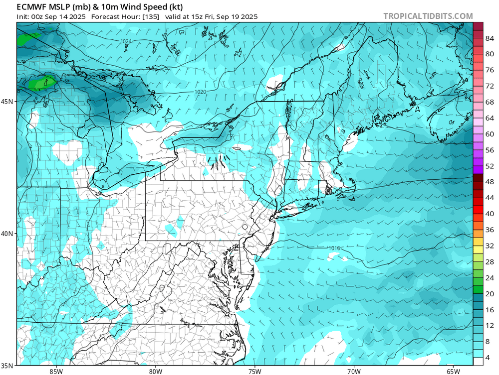
Needed more wind or more fair weather cumulus. But a 9/10 day. Gulf Stream low getting pulled north looks interesting coming into the weekdays.
-
Simply sublime. Wife and I went for a hike/walk around Beverly-Triton State Park and it was absolutely immaculate out. Temps in the mid-70s with a breeze off the Bay. Honestly couldn't ask for much better.


.thumb.png.4150b06c63a21f61052e47a612bf1818.png)

