All Activity
- Past hour
-
Wednesday's severe threat looks decent to me. Lapse rates are pretty good (6.5c/km) on the NAM and deep layer effective shear around 40 knots. Should be able to get a decent QLCS with some embedded supercells. I think the GFS is mixing out the boundary layer a bit too much.
-
upper 80s at DCA already, temp steadily climbing on a south wind. Ominous for the upcoming summer.
-
banged p good blessed
-
Would be par for the course if we watch most of this go west of apps and around us but at a minimum it looks like a return to at least scattered afternoon storms across NC most days
-
Storm means business. Really strong winds and momentarily lost power.
-
looks like you're probs getting 70 mph gusts rn
-

2026-2027 Strong/Super El Nino
forkyfork replied to Stormchaserchuck1's topic in Weather Forecasting and Discussion
can we have a separate thread for winter talk? -

2026-2027 Strong/Super El Nino
Stormchaserchuck1 replied to Stormchaserchuck1's topic in Weather Forecasting and Discussion
Nino 1+2 was close to 0.0 in 09-10. It was also the #1 most -NAO Winter on record, going back to the mid-1800s. Kind of interesting that we are batting 0-22 on Winter NAO months > +1.11 starting after just 1 year after that. -
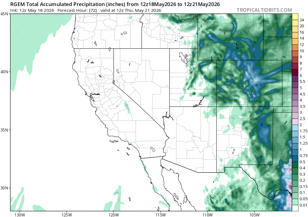
That's my concern. Some models are pushing those heavier totals west with this strong Bermuda High. TN Valley looks inundated for sure but how much makes it east of the Apps?
-

2026-2027 Strong/Super El Nino
PhiEaglesfan712 replied to Stormchaserchuck1's topic in Weather Forecasting and Discussion
09-10 showed that we can get a good winter out of a strong modoki el nino. We just need a good blocking pattern. -

E PA/NJ/DE Spring 2026 Obs/Discussion
JTA66 replied to PhiEaglesfan712's topic in Philadelphia Region
87F at noon with a DP of 70F -
(002).thumb.png.6e3d9d46bca5fe41aab7a74871dd8af8.png)
Central PA Spring 2026 Discussion/Obs Thread
ChescoWx replied to Voyager's topic in Upstate New York/Pennsylvania
Below is an analysis of when our daily climate records have occurred here in Chester County PA. Temperature, Precipitation and Snow daily records. Of note the decades of the 1930's through the 1950's accounted for 39% of our record high temperature records. The most daily record highs were recorded during the 1940's. The decades of the 1970's through 1990's recorded 40% of all of our daily record low temperatures across the county. With the 1980's recording the most daily record low temperatures. Precipitation wise the 2010's saw the most daily record precipitation records while the 1960's saw the greatest number of daily snow records.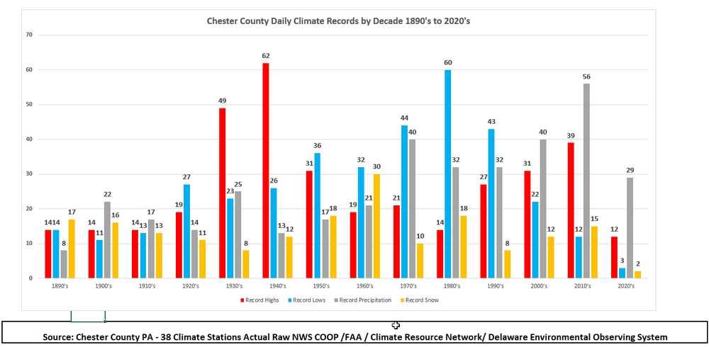
-
Currently 86 here as of noon.
-
It would be fun to see early season tropical activity. Severe looks non-existent
-
Disaster for Memorial Day weekend
-
E PA/NJ/DE Spring 2026 Obs/Discussion
ChescoWx replied to PhiEaglesfan712's topic in Philadelphia Region
Below is an analysis of when our daily climate records have occurred here in Chester County PA. Temperature, Precipitation and Snow daily records. Of note the decades of the 1930's through the 1950's accounted for 39% of our record high temperature records. The most daily record highs were recorded during the 1940's. The decades of the 1970's through 1990's recorded 40% of all of our daily record low temperatures across the county. With the 1980's recording the most daily record low temperatures. Precipitation wise the 2010's saw the most daily record precipitation records while the 1960's saw the greatest number of daily snow records.
-
Good bit of boom with em
-
Yeah the overall look on LR - weeklies never looked particularly warm, last week for ex. Talked about it then
-
71.4° SCT skies Beautiful day
-
2026-2027 Strong/Super El Nino
Stormchaserchuck1 replied to Stormchaserchuck1's topic in Weather Forecasting and Discussion
Believe it or not, April and May have a slight inverse correlation. There is 0.1 tendency for the NAO in these months to reverse each other. -

2026-2027 Strong/Super El Nino
GaWx replied to Stormchaserchuck1's topic in Weather Forecasting and Discussion
FWIW, it appears as of the current GEFS 14 day forecast that we’re probably headed for a net relatively small -NAO for May as a whole. -
Most models are also showing a decent amount of additional precip Tue-Wed.

-
Chuck, I just dropped this over in the ENSO thread because I believe that's relevant -
-
grateful for the comma head graze job as we could use the rain
-

2026-2027 Strong/Super El Nino
Typhoon Tip replied to Stormchaserchuck1's topic in Weather Forecasting and Discussion
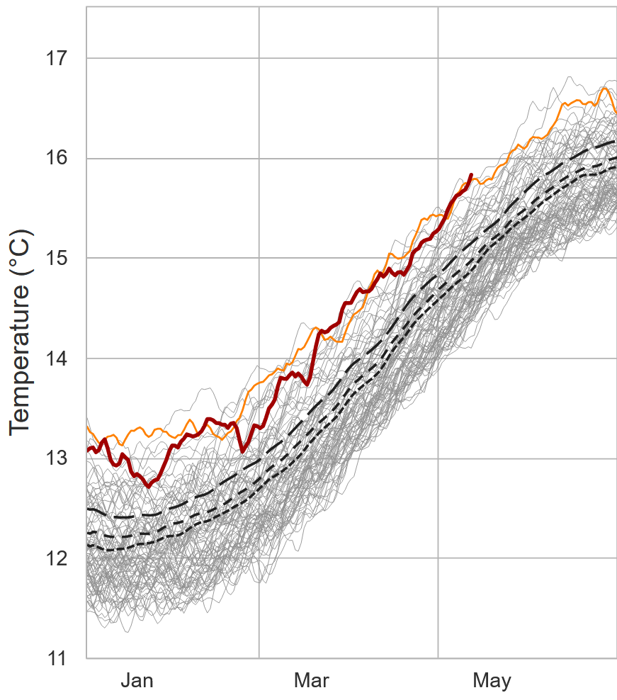
Folks may have some issue fatigue but ...too bad. We are currently crossing a date-relative historic max in the global mean temperature. This curve looks disconcerting, particularly when considering A, the quadratures are all bursting at the same time: SH/NH, Arctic/Antarctic, and Tropics. B, the last time Earth chose spring as the time of year to to flip the ENSO scrip, - to +, the whole planet did something not seen ever before: rose almost a half deg C within a two month span of time. Not sure if magnitude of ENSO means anything to that? - but I'll tell ya, it doesn't intuitively 'feel' very comforting seeing the environmental cues going so massive with the ensuing +ENSO state.


.thumb.gif.f92b16c631a1d15d405ed77b33f0710d.gif)