All Activity
- Past hour
-
This "wet" stretch of weather has been a dud locally. We've had a little over a tenth of an inch (total since Sunday). Looks like south and east of I-71 has been the jackpot zone. Still some chances today but after that it looks like it could be a while before it rains again.
-
If anything came up the coast it would transition to a cold core system so quickly. It would lose its tropical characteristics upon getting off the Carolina coast. "Worst case" scenario is some much needed rain and probably 30-40 mph gusts, mostly at the coast. And that is even fantasy
-
Yep Sent from my SM-G998U using Tapatalk
.thumb.jpg.8234d838a039225297d83c9c2662adcb.jpg)
-

September 2025 OBS-Discussion centered NYC subforum
Sundog replied to wdrag's topic in New York City Metro
Models did a piss poor job initializing the rain in PA. -
September 2025 OBS-Discussion centered NYC subforum
Sundog replied to wdrag's topic in New York City Metro
It's actually bad for your mental and physical health to be stacked on top of eachother and have constant noise pollution, another major factor people always forget. -
September 2025 OBS-Discussion centered NYC subforum
Sundog replied to wdrag's topic in New York City Metro
Very underpopulated for when they were building out the system. Pre 1950 there was still tons of farmland east of Flushing Meadow Park. Majority homes were built in the 50s and 60s out here. -

2025-2026 ENSO
donsutherland1 replied to 40/70 Benchmark's topic in Weather Forecasting and Discussion
Even for the NYC area, using a 0.0°-1.0° warm anomaly over the 1991-2020 baseline isn't a guarantee of a very bad (low) snow season. Looking at all December-March cases that fell within that range at Central Park: Mean seasonal snowfall was 16.9"; median seasonal snowfall was 13.4". In terms of seasons, 13.3% had less than 10" seasonal snowfall but 26.7% had 20" or more. Most common range: 10.0"-19.9" (60.0%). Highest: 38.6", 2020-2021; Lowest: 2.8", 1972-1973. And for 0.5°-1.5° above the 1991-2020 baseline: Mean snowfall: 19.0" Median snowfall: 17.9" Snowfall distribution: 36.4% had 20" or more 18.2% had 30" or more 45.5% had 10.0–19.9" 18.2% had less than 10" Extremes: Snowiest: Winter 2005-2006 with 40.0" Least snowy: Winter 1972-1973 with 2.8" If one were looking at a 40.0° winter, that would signal very bad prospects. -
.01 today...tonight looks good to maybe cancel the governor's no burn order. Finally some freakin' weather.
-
GFS says what rain? Develops 93L and recurves and does very little with 94L
-
Nah... dews in the 50s early next week (IMBY
-
I am not a fan of high dews
-
 Although there’s not much in the way of low level center, there’s a pretty robust mid level reflection as evidenced by visible satellite and TJUA radar. Not sure I buy the 12z GFS evolution.
 -

September 2025 OBS-Discussion centered NYC subforum
LibertyBell replied to wdrag's topic in New York City Metro
Most people aren't interested in being packed like sardines in a subway train. It's why densely packed cities are antithetical to good environmental and health policies. -

September 2025 OBS-Discussion centered NYC subforum
gravitylover replied to wdrag's topic in New York City Metro
$$ -

2025-2026 Fall/Winter Mountain Thread
Maggie Valley Steve replied to Buckethead's topic in Southeastern States
The 12Z GFS solution suggests our rain chances will continue over the next 5 to 7 days with some SW Mountain locations possibly exceeding 5 inches -
Both will be wrong.
-
September 2025 OBS-Discussion centered NYC subforum
LibertyBell replied to wdrag's topic in New York City Metro
I've always wondered about that, why wasn't the subway ever extended to include all of Queens and Staten Island? -
The Euro / ICON would be a nice drought stopper. Not too much rain to flood anything out, but enough to put us back in the right direction.
-

E PA/NJ/DE Autumn 2025 Obs/Discussion
BBasile replied to PhiEaglesfan712's topic in Philadelphia Region
Not a fan.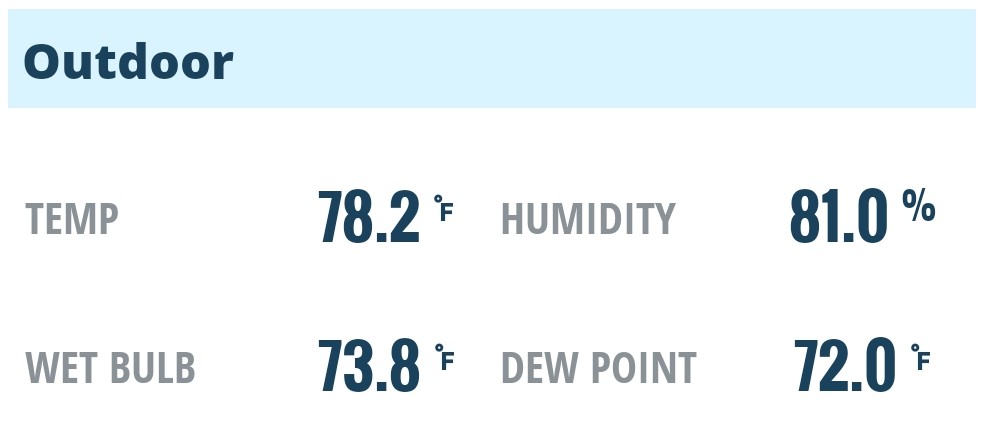
-
Looks like 83" imby last winter. Definitely was a good winter, especially after the past few terrible ones.
-
We definitely needed the rain, it's been a dry few weeks. Fall is definitely in full swing with leaves starting to drop. Temps have been pleasant and next week looks beautiful!
-
When there’s ever a good outcome for my latitude east of the Apps again I’ll go with what you’re saying. I hate the bad news as much as anyone but there’s solid reasoning behind it and little evidence it’s changing soon.
-
September 2025 OBS-Discussion centered NYC subforum
Sundog replied to wdrag's topic in New York City Metro
I'd rather die Plus there's no regular train where I am, I'd have to get on the LIRR just to get to the subway. -
Above normal temps are expected through the period with temps well into the 70s into early next week. Ensembles are indicating low probs for 80F so some 80 degree readings are possible for a few days. Lfg
-

September 2025 OBS-Discussion centered NYC subforum
psv88 replied to wdrag's topic in New York City Metro
79/70 feels like July


.jpg.2c02cfe969827ad5309c43d42ecbfec6.jpg)


