All Activity
- Past hour
-
It's possible given the look. Still pretty far out. GFS suggesting some upslope in early November with LES in the NW flow behind a cold front.
-

Spooky Season (October Disco Thread)
dendrite replied to Prismshine Productions's topic in New England
Yeah a d10 CMC snowicane. What could go wrong? -

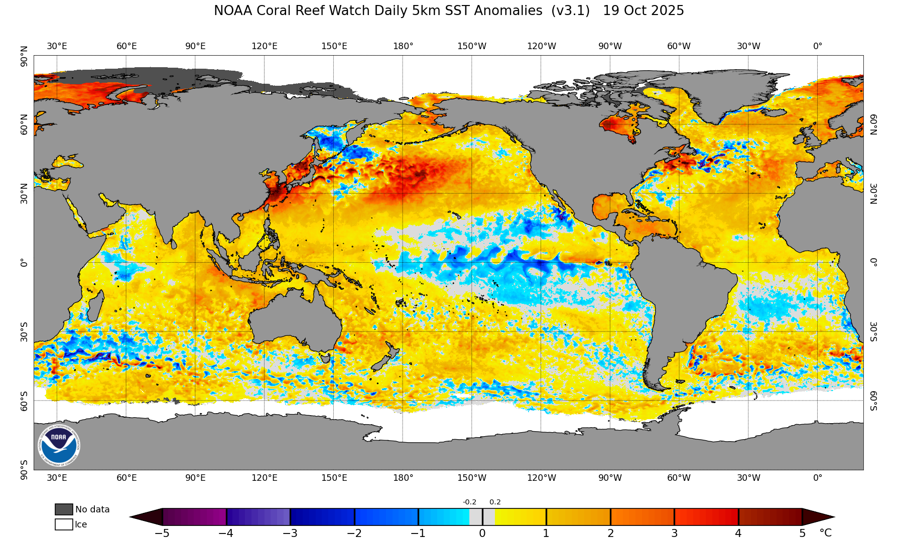
2025-2026 ENSO
Stormchaserchuck1 replied to 40/70 Benchmark's topic in Weather Forecasting and Discussion
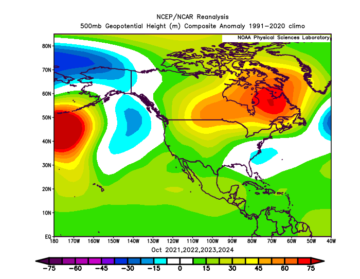
October is interesting because there is a big negative 500mb anomaly over and around Alaska in the -PDO.. and -PDO's when the warm SSTA has been predominant pattern. You would think warmer water temps would be linear with warming somewhere else or there.. but it's a -0.5 H5 correlation that occurs consistently for the last 75 years. -

Spooky Season (October Disco Thread)
moneypitmike replied to Prismshine Productions's topic in New England
Nothing more exciting than a Day 10 CMC. -
Wonder if the mountains could get their first accumulations out of that? Would love to go on a 3 hour jaunt if it meant seeing October snow.
-
36.6 with first frost on rooftops and some in grassy areas.
-
1. 6Z Euro 144: significant shift NE vs 0Z 150 and 12Z 162 (which were both 150-200 miles SSW to SW of Jamaica) with the 6Z 40 miles E of Jamaica. That’s a 200-250 mile NE shift from the 0Z/12Z! 2. Tropical Weather Outlook NWS National Hurricane Center Miami FL 800 AM EDT Tue Oct 21 2025 For the North Atlantic...Caribbean Sea and the Gulf of America: 1. Caribbean Sea (AL98): Satellite, radar, and surface observations indicate that the area of low pressure over the central Caribbean Sea appears to be developing a well-defined center, and is already producing winds up to 45 mph. A tropical storm is expected to form later today while it slows down over the central Caribbean Sea. Heavy rainfall and gusty winds are possible over portions of the ABC Islands during the next day or two. Interests in Puerto Rico, Hispaniola, Jamaica, and Cuba should monitor the progress of this system as there is a risk of heavy rain and flooding, strong winds, and rough surf later this week. The Air Force Hurricane Hunters are scheduled to investigate the system later today. For additional information on this system, including Gale Warnings, please see High Seas Forecasts issued by the National Weather Service. * Formation chance through 48 hours...high...near 100 percent. * Formation chance through 7 days...high...near 100 percent. High Seas Forecasts issued by the National Weather Service can be found under AWIPS header NFDHSFAT1, WMO header FZNT01 KWBC, and online at ocean.weather.gov/shtml/NFDHSFAT1.php Forecaster Cangialosi
-

Spooky Season (October Disco Thread)
Damage In Tolland replied to Prismshine Productions's topic in New England
Aween -
32.5 for the low. Big Jacket morning
-
Could be a feedback response involved with the overpowering WPAC warm pool with this -PDO and Atlantic warm pool enhancing the ridge into a stronger standing wave.

-
42 chilly degree's this morning at work. Big temp difference from home to work. Felt great walking in.
-
First freezing temp of the season here this morning (barely), low was 31.6 degrees. Currently 31.8/31.1 with mostly clear skies.
-

Spooky Season (October Disco Thread)
kdxken replied to Prismshine Productions's topic in New England
Here's more for you. -
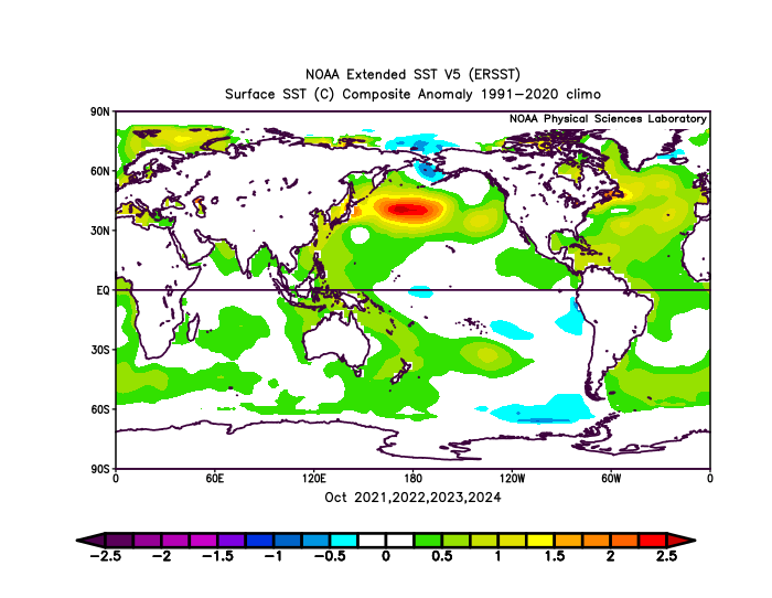
2025-2026 ENSO
Stormchaserchuck1 replied to 40/70 Benchmark's topic in Weather Forecasting and Discussion
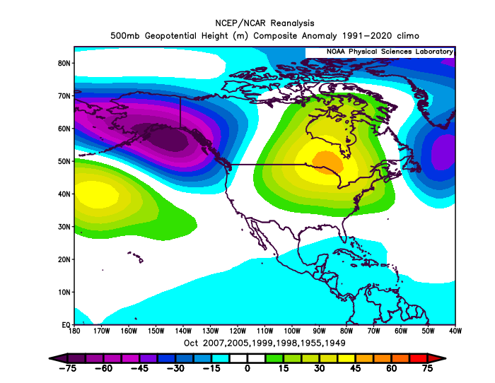
Pretty interesting because 2021-2025 isn't even included in that composite! From 1948-2020 + and - phases had almost a 0.4 correlation with the PDO over SE Canada. And now in the last 5 years that correlation is growing bigger! -

Spooky Season (October Disco Thread)
MJO812 replied to Prismshine Productions's topic in New England
Aleet
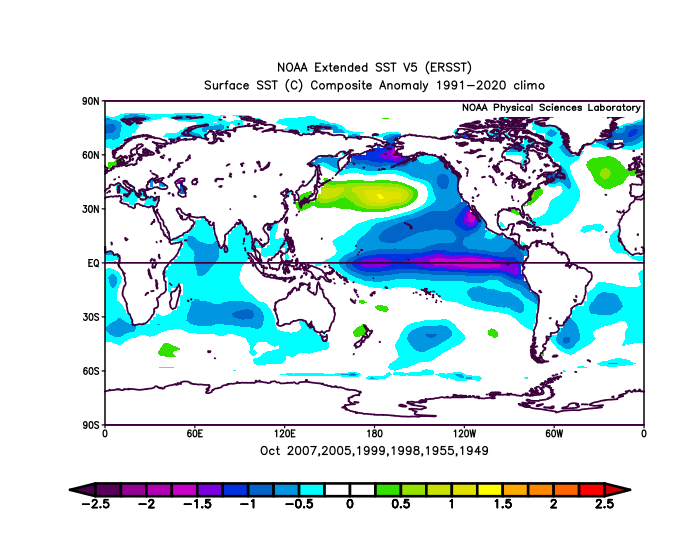
-
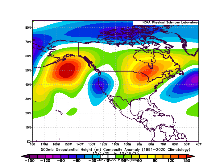
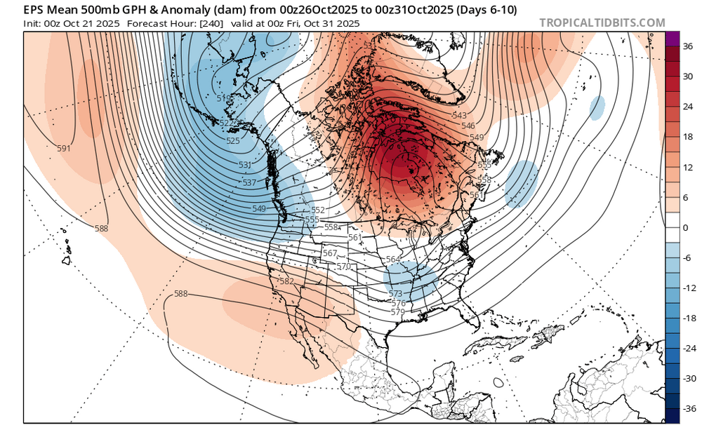
Much stronger 500 mb heights over Canada with the 2020s -PDO vs during the earlier era. Also notice the more impressive North Pacific ridge. Plus the volatility next 10 days with the big EPO shift.
-
Continues this morning with the 00z/21 EPS much deeper at 5H than the 00z GEFS, but the 06z GEFS has deepened bug not yet responsive at the surface and resultant rainfall. No thread yet, dependent on la/lo of sfc low and its gradient. It will rain in that period, seemingly Oct 29-30 and may bring October monthly to normal. Too early for me on a thread. EPS twice as much qpf than the GEFS and CMCE so not a lock on a strong system.
-
38
-
If you exterminated mosquitos you’d lose a lot of aquatic life that feed in their larvae. You’d also lose quite a few other species. Bats need mosquitos too. Draining wetlands leads to increased disease spread. Most of the aggressive mosquitos are NOT from swamps and marshes. But they are from stagnant standing water like clogged gutters, untreated pool covers, used tires filled with water inside (hence it is illegal to store tires outside with the inside exposed within nyc).
-

2025-2026 ENSO
40/70 Benchmark replied to 40/70 Benchmark's topic in Weather Forecasting and Discussion
Maybe I came off my confrontation that I intended...didn't mean to put you on the defensive. -

Central PA Fall Discussions and Obs
pawatch replied to ChescoWx's topic in Upstate New York/Pennsylvania
32 degrees and foggy. .38” of rain from the storm yesterday. -
Yup! That run was a snooze fest. Hopefully something interesting pops up soon.
-
This literally might be the dumbest f**king thing you have ever said on here and you say a lot of dumb $hit. Our wetlands provide flood control, pollution management, and yes disease regulation. They are some of our most productive systems. I’m sorry but you really need to be 5-posted with posts like this. Hell much of the reason we have awful flooding in the USA is because of how we got rid of so many wetlands…
-

Monday, October 20, 2025 Squall Line Potential
SJonesWX replied to weatherwiz's topic in New England
1.5" here. neighborhood stream is still dry -
2025-2026 ENSO
40/70 Benchmark replied to 40/70 Benchmark's topic in Weather Forecasting and Discussion
Yes, but I was pretty clear on that portion of your statement, so why would I address it?