All Activity
- Past hour
-

January 2026 regional war/obs/disco thread
40/70 Benchmark replied to Baroclinic Zone's topic in New England
Change your screen name to Sugarloaf1996 -

January 2026 regional war/obs/disco thread
WinterWolf replied to Baroclinic Zone's topic in New England
This is fluid…it’s morphing/it’s trending. The storm hasn’t even formed yet, and the confluence isn’t here yet either, there will be changes. That’s all you can say at this moment. Also These elements are not being handled perfectly at this juncture either. -

January 2026 regional war/obs/disco thread
metagraphica replied to Baroclinic Zone's topic in New England
18.1" -
Winter 2025-2026 Offers Return to Normalcy
40/70 Benchmark replied to 40/70 Benchmark's topic in New England
Verification of Sunday Night-Early Monday Snowfall Decent But Flawed Forecast Effort Here are the verified region wide snowfall amounts for the storm that concluded on Monday morning versus the Eastern Mass Weather Final Call map issued on Saturday. There were three primary issues with the forecast map. 1) 4-7" would have been a more appropriate range as opposed to the 3-6" range that was selected. 2) This 4-7" range should have encompassed the entire 2-4" area over Rhode Island and southeastern Massachusetts, out to about the mid cape. This is because the system became slightly more intense and tracked a bit further east than implied, which resulted in greater dynamics and more snowfall over this area. 3) Finally, the Western cut off should have been slightly more abrupt, thus the 1-3" should have extended back near the Connecticut River. FINAL GRADE: B- -
I'm just so unused to forecasts like this. This is rather mind-blowing:
-
Rise of the Machines: January 18-19 Winter Storm Obs Thread
40/70 Benchmark replied to WxWatcher007's topic in New England
Verification of Sunday Night-Early Monday Snowfall Decent But Flawed Forecast Effort Here are the verified region wide snowfall amounts for the storm that concluded on Monday morning versus the Eastern Mass Weather Final Call map issued on Saturday. There were three primary issues with the forecast map. 1) 4-7" would have been a more appropriate range as opposed to the 3-6" range that was selected. 2) This 4-7" range should have encompassed the entire 2-4" area over Rhode Island and southeastern Massachusetts, out to about the mid cape. This is because the system became slightly more intense and tracked a bit further east than implied, which resulted in greater dynamics and more snowfall over this area. 3) Finally, the Western cut off should have been slightly more abrupt, thus the 1-3" should have extended back near the Connecticut River. FINAL GRADE: B- -
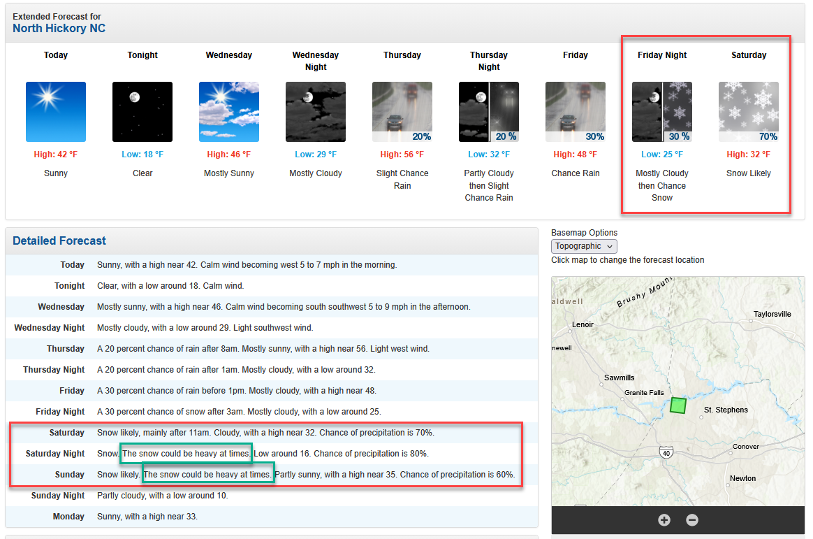
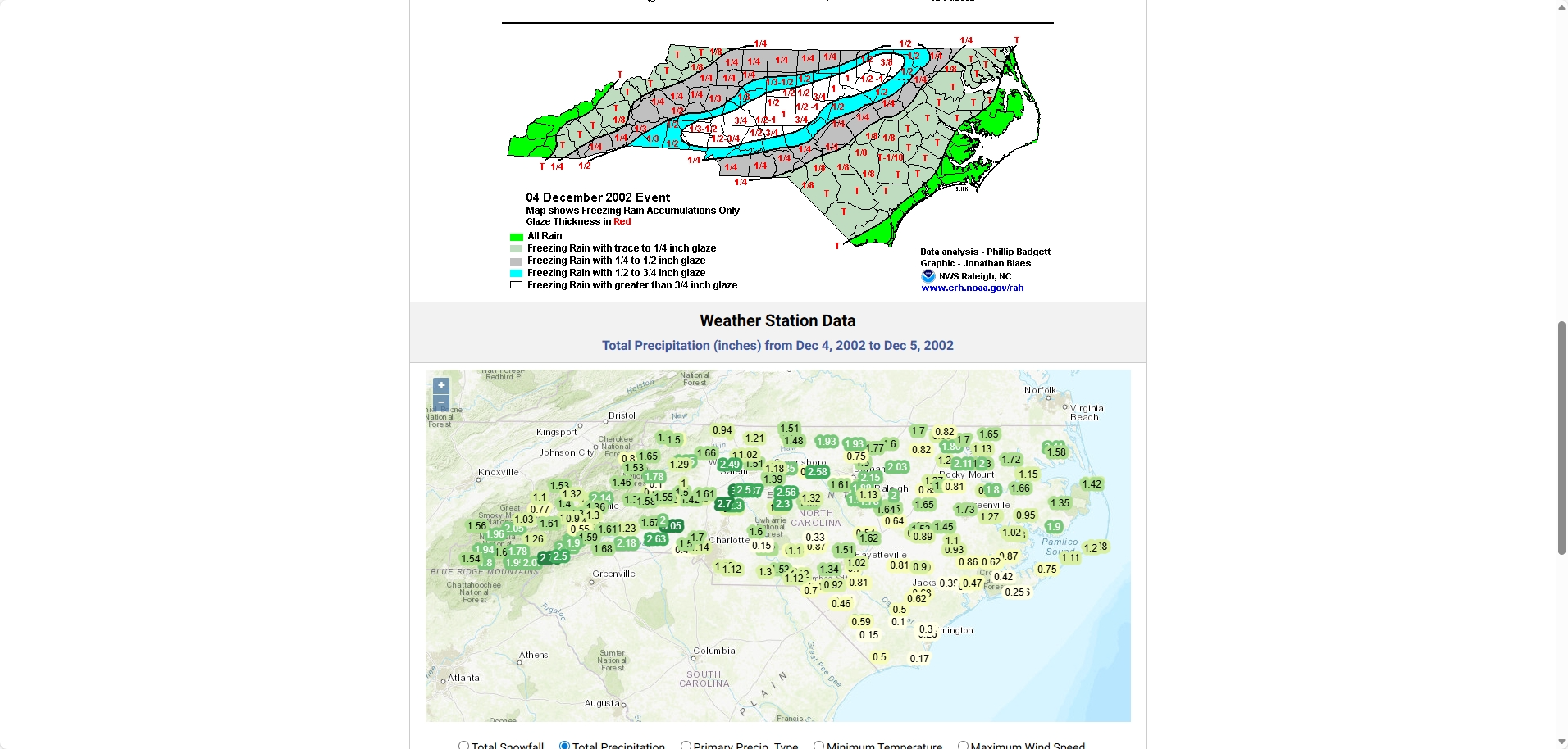
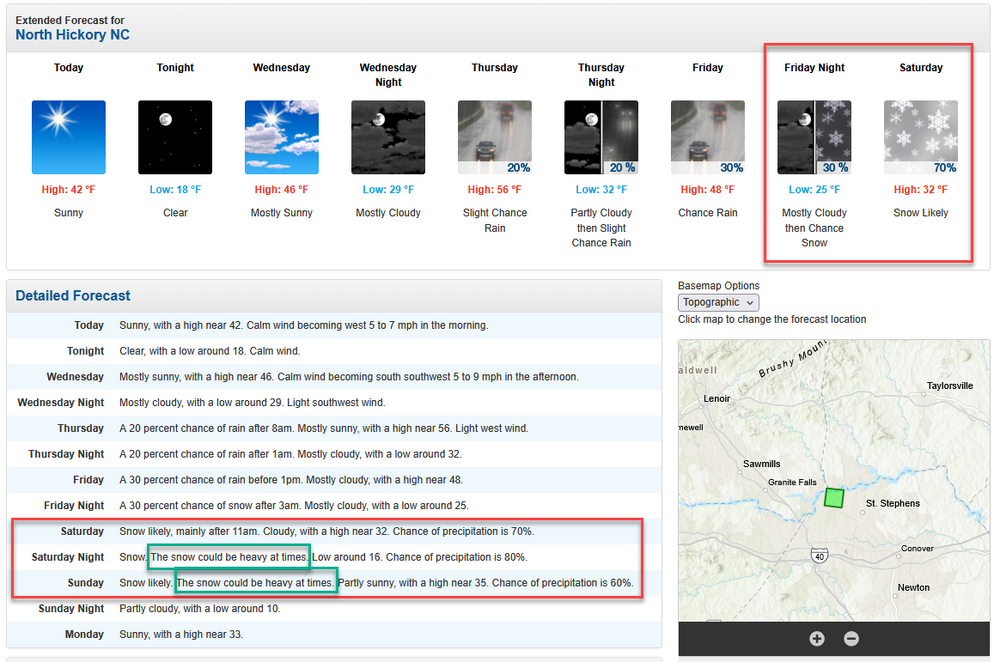
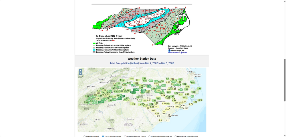
Winter Storm Event – Products | North Carolina State Climate Office
-

January 2026 regional war/obs/disco thread
Sugarloaf1989 replied to Baroclinic Zone's topic in New England
This storm potential reminds me alot of the Blizzard of 1996. Very cold with that storm. I was skiing at Sugarloaf Maine and it was well below zero during the daytime before the storm came up the coast. No snow fell in Northern New England. My parents house had 25" of snow in Northern Queens NYC with huge drifts. Feather light fluffy snow. -

January 2026 regional war/obs/disco thread
weatherwiz replied to Baroclinic Zone's topic in New England
Confluence is always a PITA to forecast but I think right now, I would favor a track more north. As modeled, the bulk of the confluence being more north I think favors potential for additional northern pushes. But we also have room to continue building the heights northeast of this. The degree and intensity of CAD into the mid-Atlantic may also play a big factor -
Of course. I also remember the beautiful clown maps from the NOGAPS
-

Pittsburgh/Western PA WINTER ‘25/‘26
RitualOfTheTrout replied to Burghblizz's topic in Upstate New York/Pennsylvania
I agree, I think we are approaching the ceiling for how far north it can come, being in the bullseye would take significant changes. The changes in the handling of the phasing with the southern stream shortwave last night were what we wanted to see though, and as long as that continues, and we see some relaxation in the confluence at least we won't be totally shut out. -
It’s 12 right now; touched 8 this morning at dawn.
-
That's a prime setup for us to win big time.
-
I know we will have the heavy snow and the cold temps in teens.. but I. Curious if we will have high enough winds to reach blizzard criteria anyone seen and wind data for this storm?
-

January 2026 regional war/obs/disco thread
Kitz Craver replied to Baroclinic Zone's topic in New England
I’m not sure a compromise in this situation will work for us to have a significant event though. We need solid northern trends -

Possible Record Breaking Cold + Snow 1/25 - 1/26
donsutherland1 replied to TriPol's topic in New York City Metro
Although the potential storm is 4-5 days out from beginning to affect parts of the East Coast, many of us have seen this proverbial movie before. Arctic high pressure and strong confluence were expected to crush the storm to the South, yet as the event drew closer, the high and the confluence were somewhat weaker than previously modeled. It's too soon to focus on specific solutions, but the potential for snow remains very much on the table for Sunday in the New York City area. While we wait for the 12z cycle to weigh in, here are some tidbits from past storms. Storm 1: THE END OF WEEKEND MAY BRING SOME INTERESTING WEATHER. A STORM SYSTEM WILL BE GETTING ORGANIZED IN THE SOUTHERN PLAINS AND HEADING TOWARD THE CAROLINA COAST. IT IS STILL TOO EARLY TO DETERMINE EXACTLY HOW THIS STORM MIGHT EFFECT THE TRI-STATE. STAY TUNED... Storm 2: LATEST RUN OF THE GFS NOT VERY ENCOURAGING FOR SUNDAY INTO MONDAY EVENT. STRONG HIGH WITH CLASSIC DAMMING LOOKS TO WIN OUT. HEAVY SNOW A BETTER BET ACROSS MID-ATLANTIC. Storm 3: WILL CONTINUE TO KEEP AN EYE ON A SOUTHERN STREAM SYS PASSING TO THE SOUTH THIS WEEKEND, AS MODELS ARE LIKELY SUPPRESSING IT TOO FAR SOUTH VIA TOO STRONG OF A POLAR JET/MID LEVEL CONFLUENCE ZONE FROM NEW ENGLAND OVER TO NOVA SCOTIA, TO THE REAR OF A 50/50 CLOSED LOW. DETERMINISTIC 12Z GFS IS DRY AND 00Z ECMWF GIVES ONLY A GLANCING BLOW WITH SOME LIGHT SNOW. THEIR ENSEMBLE MEANS ARE A LITTLE LESS SUPPRESSED... If anyone wants the answers to which storms these are, storm 1 is the Blizzard of 1996 (NWS New York, January 5, 1996 3:53 am). Storm 2 is PD2 in 2003 (NWS New York, February 14, 2003 9:15 pm). Storm 3 is the potential January 24-26, 2026 storm (NWS New York, January 19, 2026 7:11 pm). This does not guarantee a major event for the New York City area. But that scenario cannot be ruled out at this lead time. For further trivia, the last storm to bring 6" or more snow to Baltimore, New York City, Norfolk, Philadelphia, Raleigh, Richmond, and Washington, DC was the February 1979 (PD1) blizzard. So, at least some of the guidance is hinting at a rare solution. As the NWS advised ahead of the 1996 blizzard, stay tuned. -

Central PA Winter 25/26 Discussion and Obs
paweather replied to MAG5035's topic in Upstate New York/Pennsylvania
Time for 12z -
I hope you’re right. I usually hang out in the Mid-Atlantic forum because I’m in Richmond, and the D.C. and north crew are honking about it trending north. .
-
A lot of that will be sleet on the ZR map. Especially as you get farther north. Don't get me wrong though, those who are in the primary ZR zone will be smashed if this comes to fruition.
-
Only got to 20 last night.
-
Well said Mr. rclab, a philosophical response, one I echo. Went through my 12th holiday season without my wife- not competing with you rclab;just the way it is- and there will almost certainly be more snow, even if you have to go find it. But Mr.vegan_edible, finding true love a lot more difficult. Coulda shoulder woulda can place you in a world of regret. Side note-could you get her a plane ticket to you? Envision this-a snowy scene with a crackling fire and the woman you love-what could be better than this? Pray and hope that you make the right choice-for both of you. And now back to the weather..
-
Note the trajectory is more sw/ne. That's great to see.
-
Cap for this storm if everything pans out is probably a bit above the 12z Ukmet. Now, of course, I don't think thats the likely cap but it is probably near the theoretical cap. Likely cap is probably something like the 6z Euro with a foot and a half area wide plus area wide. The reason the euro is less snowy is the interaction with the NS goes differently than the Ukmet. On the Ukmet it actually stretches the vorticity out while still helping the eastern part of it generate a strong low pressure. This is why the Ukmet is pretty far south with its mixing line. However, it manages to also have insane moisture transport from this whole stretching business. I mean lmao it has the jet streak start over the Pacific and a secondary right entrance quadrant over us. Couldn't ask for much better. Meanwhile the 6z Euro actually has a cleaner phase out west. Eventually it all wraps up in one big vorticity ball and comes east. This is what allows it to climb the coast and make people like @brooklynwx99 very happy. However, for us it's "worse" because 1. mixing line is further north and 2. for us it technically doesn't have quite the same moisture fetch from the Pacific and the double left exit region/rear entrance region lift combo. Overall I think that sums up the differences pretty well. They key reason for all this btw is that the Ukmet is faster with the SW which allows it to have that messy NS interaction. It also means our storm starts and ends before the Euro does the same. Ultimately I think both solutions are great though ofc I would prefer the Ukmet (and to some extent think a messy phasing thing out west is more likely). I'll make a more in depth post after the 12z runs come it.
-

2025-2026 ENSO
Stormchaserchuck1 replied to 40/70 Benchmark's topic in Weather Forecasting and Discussion
^I've done that exercise too many times over the years lol Here's the monthly PNA data: https://www.cpc.ncep.noaa.gov/products/precip/CWlink/pna/norm.pna.monthly.b5001.current.ascii.table 65-66 and 72-73 were the greatest anomalies.. -PNA. -
January 2026 regional war/obs/disco thread
WinterWolf replied to Baroclinic Zone's topic in New England
A little of both…a compromise. Slow it down a little like some modeling is showing, I think our chances improve greatly.