All Activity
- Past hour
-

January 2026 Medium/Long Range Discussion
Stormchaserchuck1 replied to snowfan's topic in Mid Atlantic
I see it briefly at 264hr. The 360hr 0z EPS has a favorable look -
Those of us who got 0.00” from last weekends rain are not going to be in good shape
-

January 2026 regional war/obs/disco thread
NoCORH4L replied to Baroclinic Zone's topic in New England
If we could get record breaking Fairbanks cold, I'm sure many would take a week of that. At a minimum, the pipe breaks and ice skating on the Charles would keep the news exciting more than it is now I suppose. 40/70 doing Ice Road Truckers on the Charles to skip traffic -
Long range has been awful but yet people still forecast based off of it.
-
Models looked awful last night and now all of a sudden the Euro shows a little something for Sunday now. This is a tiresome hobby lol
-
20-30 inches There should be a snowy period in the 2nd half of this month and into February.
-
The 0z Canadian Para is how I think this week unfolds. the 6z Euro does have a sneaky little system again along the Gulf for the weekend...if that were to back westward? I don't think it is overly realistic, but the GEM para has a second vortex, but it slides over the Tenn Valley. Multiple, light waves of snow in that cold air makes a lot of sense for the weekend.
-

January 2026 Medium/Long Range Discussion
SomeguyfromTakomaPark replied to snowfan's topic in Mid Atlantic
Def a good pattern for SWFE shaping up for end of January. Hopefully we can cash in a big qpf one that hammers the whole forum. -
Around 20
-

January 2026 regional war/obs/disco thread
UnitedWx replied to Baroclinic Zone's topic in New England
Long range on the models look dead... good. Lets get something to appear within 4 maybe 5 days, instead of chasing fantasies -

January 2026 regional war/obs/disco thread
moneypitmike replied to Baroclinic Zone's topic in New England
For all those looking to water their lawns in March. -

January 2026 regional war/obs/disco thread
qg_omega replied to Baroclinic Zone's topic in New England
The northern and southern jets are dead, we stein -

E PA/NJ/DE Winter 2025-26 Obs/Discussion
Violentweatherfan replied to LVblizzard's topic in Philadelphia Region
MJO forecast was forecast for this time period to be in phase six, and is. It won’t be any where near phase eight until the end of this month -

January 2026 regional war/obs/disco thread
Sey-Mour Snow replied to Baroclinic Zone's topic in New England
Only hope for widespread snow is a NW amplification trend on around MLK day for the next 7 days.. Guidance is still all over the place after that in terms of where the cold goes and where the gradient sets up .. There also seems to be an overrunning set up the end of next week in the 9-12 day range .. But again have to see where the gradient sets up -
Very boring on the models. This is awful .
-

January 2026 regional war/obs/disco thread
mahk_webstah replied to Baroclinic Zone's topic in New England
Although WPC still has some risk of storm 18-19th -

2025-2026 ENSO
donsutherland1 replied to 40/70 Benchmark's topic in Weather Forecasting and Discussion
I have a list of Southeast Region snowstorms and just checked the dates last night. The date range is where the Southeast was receiving snow.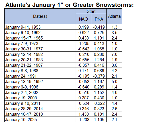
-
January 2026 regional war/obs/disco thread
mahk_webstah replied to Baroclinic Zone's topic in New England
Except for a bit of rain and snow midweek, all precipitation gone from 10 day. Pretty much the worst case scenario from where this looked to be headed. Quite a surprise to me tbh. Cold and dry sucks. Much prefer cutter to wipe it clean and be warmer outside. otoh this will probably change but seems like quite a fail for mid range models. Or maybe just a perceptual bias based on large number of models and frequency of model runs? -

January 2026 regional war/obs/disco thread
Damage In Tolland replied to Baroclinic Zone's topic in New England
This is a winter of Stein . Water bans by Morch -
January 2026 regional war/obs/disco thread
qg_omega replied to Baroclinic Zone's topic in New England
Almost no QPF for two weeks as well -
No keep him.
-
IMO neither Ravens nor Steelers should have been in the playoffs. Neither was that good this year and certainly were not among this season’s elite teams.
- Today
-

January 2026 regional war/obs/disco thread
CoastalWx replied to Baroclinic Zone's topic in New England
Hold me -
January 2026 regional war/obs/disco thread
moneypitmike replied to Baroclinic Zone's topic in New England
Joke aside--it is showing really cold. -
I spy a little -PNA the last week of Jan. I hope models are still biased too low on PNA


