All Activity
- Past hour
-

January 2026 regional war/obs/disco thread
CoastalWx replied to Baroclinic Zone's topic in New England
Yea that’s after any warm up. That probably would work verbatim. However every time we have seen that something shits the bed. -

January 2026 regional war/obs/disco thread
WinterWolf replied to Baroclinic Zone's topic in New England
To my untrained eye, That isn’t a bad look there. I mean it is 14-15 days away, so we know the deal. But verbatim that looks pretty decent, and getting into peak climo. -
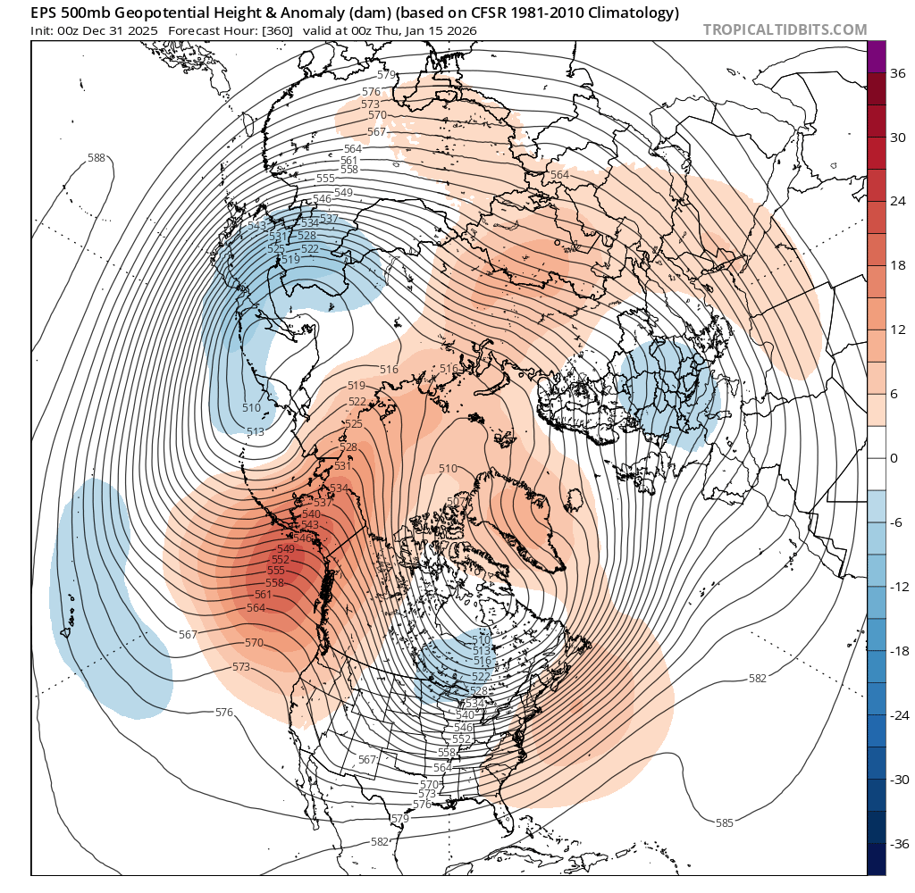
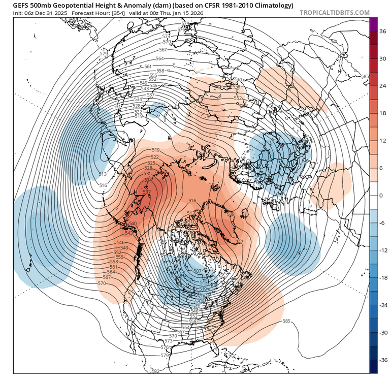
Per recent verification scores, it's a tad concerning the 0z GFS is more pro-cold than the 0z Euro, granted one run doesn't make a forecast. I imagine models are picking up on a transient warm spell before the hammer drop. As Carver noted last week, it just takes a few members to skew the batch. Still scratching my head why CPC is so warm for in their extended outlooks. Also, 'tis interesting amidst the flip-flopping, there are signs a +TNH pattern may develop. That in tandem with a -EPO can work for most of the forum but given the SE ridge pumping that signal can induce, I prefer the 'old school' -NAO/-AO being a more dominant driver. At least the southern jet looks cooperative. Preferably, I like average to slightly below average precip for January/February given what that can imply. I recall past Nina winters that went super zonal in January. Doesn't look that way this go-around.
-

12/31-1/1 Possible Snow Showers/Squalls to Start 2026
nj2va replied to bncho's topic in Mid Atlantic
Nice! Even a broken clock is right twice -
12/31-1/1 Possible Snow Showers/Squalls to Start 2026
nj2va replied to bncho's topic in Mid Atlantic
Overperformed overnight with this initial disturbance. I drove out to Morgantown at 630a for a workout class at Orangetheory which wasn’t the best idea. White knuckle driving the whole way on 68. Roads were not in good shape between the falling and blowing snow. We had about 1.5” when I left the house, time to head back. -
December will come to a close today with 26 days of snow cover out of 31. Temperatures will average about 3.0° below the new high normal, and snow fall for the month will close with 17 inches. Other than Christmas being barely white the month closes as a sold A-. A white Christmas like last year, with a 4-5 inch snowpack on the ground Christmas morning, would have made it an A.
-
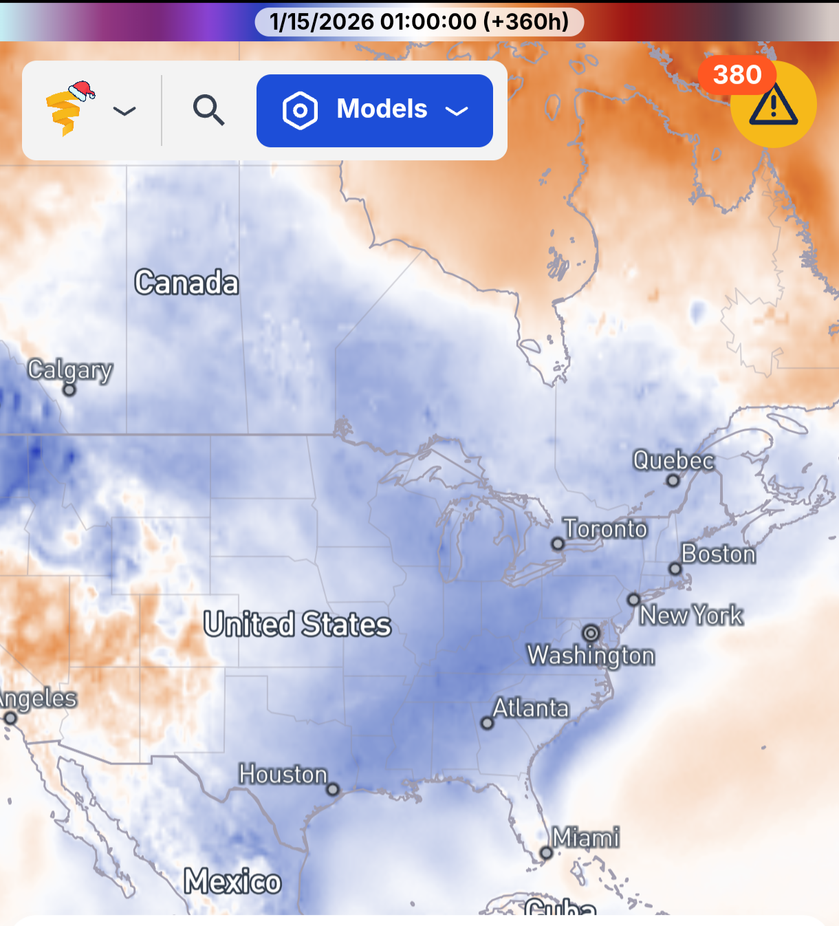
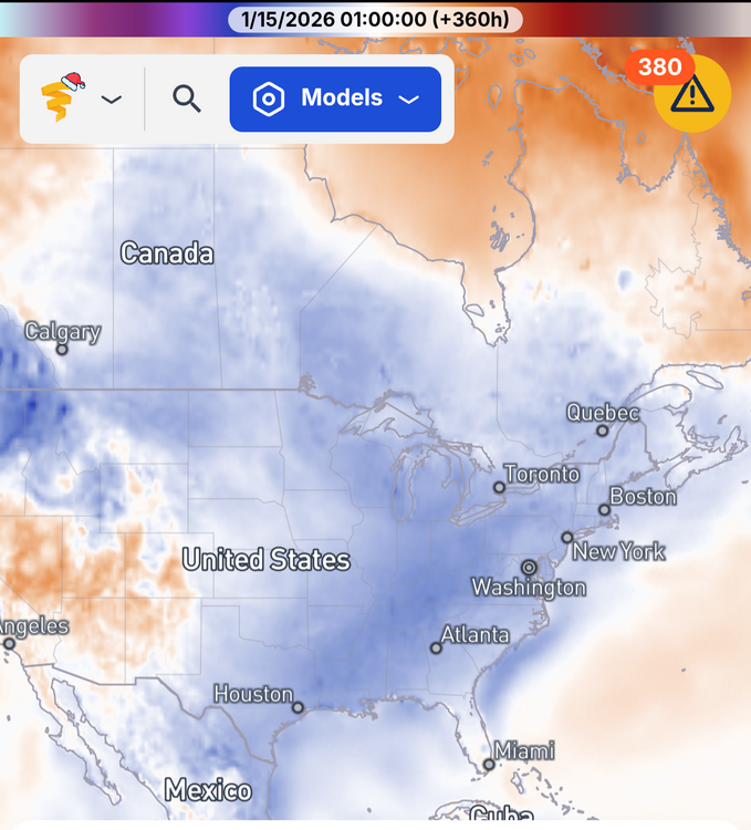
GEFS and AI GEFS both showing cold around the 12th, while the EPS is warm
-
1.5"
-
January 2026 regional war/obs/disco thread
CoastalWx replied to Baroclinic Zone's topic in New England
Maybe an 8-14” Leon event visits? -
There is snow on the beach at OCMD this am.....pull up a webcam!
-

January 2026 regional war/obs/disco thread
ORH_wxman replied to Baroclinic Zone's topic in New England
I’ve had one double digit storm (and it was barely double digits) since Feb 2022. This truly feels like that 1988-1992 stretch except warmer (at least prior to last winter) and not quite as paltry on seasonal snow totals here…but close enough. Really could use a big storm to break the drought. -

January 2026 regional war/obs/disco thread
dendrite replied to Baroclinic Zone's topic in New England
Maybe we risk some cutters, but I’m only interested in big ticket items. -
January 2026 regional war/obs/disco thread
ORH_wxman replied to Baroclinic Zone's topic in New England
Monday doesn’t look that interesting unless northern stream digs a little more for a stronger IVT. Otherwise prob flurries or C-1”. -
January 2026 regional war/obs/disco thread
dendrite replied to Baroclinic Zone's topic in New England
In their defense, the southern plains ridge started as a SE ridge in the distant LR as well before trending more west. Difference is, it seems the ens are trying to flush the cold in eastern Canada this time. I would roll with this…in the interior at least.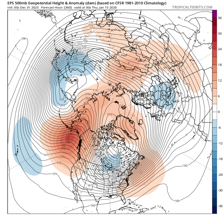
-

Central PA Winter 25/26 Discussion and Obs
pasnownut replied to MAG5035's topic in Upstate New York/Pennsylvania
3 days in a row. yeah...my wires dont alwasy touch. My cheeks look like santas after his annual trek round the world. Takin today off. Lotsa miles on my boots and I'm not compainin. Glad that I can do it. Today was total gym and ab roller (done), so now headed into work for a couple hours (even though I'm technically "off"). To all my pals here, happy NYE, and all the best in the New Year. -

January 2026 regional war/obs/disco thread
Damage In Tolland replied to Baroclinic Zone's topic in New England
Tonight’s is 2 -4 there . Another 2-4 Monday.. then we’ll see mid week . Hopefully you have a Ring so you can watch it vicariously -
Agreed. Right now the south East Ridge has been pushed back quite a bit so any storm that comes towards our area would likely not be interfered by that ridge and we would not run the risk of the storm being amplified too much and cutting to our west. Instead, our current problem is that we don’t have enough amplification because the northern stream is just flowing too fast and cannot phase with the southern stream in time to lead to a large coastal storm. However, it looks to be towards mid month that there is a shake up in the Pacific, which will push the mild air in the west and central US over the east US briefly. Then afterwards we will appear to be in a more of a colder regime similar to what we are in now but this time the cold will be more widespread across the US. While that will likely increase the chances for snow because our snow storms will have already been formed to our west and traverse across the US, we do run the risk of a larger southeast Ridge, which would lead to potential over amplification and temperature issues during those storms. So for now, we have the cold, but we don’t have the snow, and in a few weeks it’s looking like we might have the cold, but we have issues with the southeast Ridge, which will of course affect our chances for snow as well. Either way, we need a big shake up in the Pacific because most of the US is snapping back to warm and dry for the foreseeable future, which doesn’t go well for our chances either.
-
January 2026 regional war/obs/disco thread
CoastalWx replied to Baroclinic Zone's topic in New England
I’ll be fine missing an inch. Looks quiet to me. -
January 2026 regional war/obs/disco thread
Damage In Tolland replied to Baroclinic Zone's topic in New England
Snow tonight, snow Sunday night/ Monday and snow Jan 6. Wouldn’t call that quiet. You’ll miss a few snowfalls -
January 2026 regional war/obs/disco thread
CoastalWx replied to Baroclinic Zone's topic in New England
Yeah verbatim I don’t think it would be prolonged, just saying it looks to happen. Seems like a quiet 7 days coming up. -
January 2026 regional war/obs/disco thread
Damage In Tolland replied to Baroclinic Zone's topic in New England
There’s been no SE ridge all winter -
I’m a little less lighter on my feet these days with two little boys in tow but we made their (3 and 1) inaugural unplanned snow run to Canaan with me. Blackwater Falls State Park this morning. 4-6 inches last 24 hours (still falling- IT JUST SNOWS HERE) with another 6-10 expected overnight.
-
I clouded over around 3 am and the flurries returned. It WAS 18.3 around 2 am, climbed once those clouds filled in. Up to 24.4/16.7 at 8 am here.
-
19.6 this morning. Enjoy this last day of 2025.
-
To add to this, IF said +TNH pattern (-EPO/+AO/+NAO/SE ridge) develops just after mid-month into late January, it would argue for overrunning events and SWFEs. The question then becomes does it favor New England? Or PHL/NYC north into New England?