All Activity
- Past hour
-
1 week until pitchers and catchers report.
-

2025-2026 ENSO
PhiEaglesfan712 replied to 40/70 Benchmark's topic in Weather Forecasting and Discussion
1993-94 (and possibly even 1995-96) was the result of the after effects of Pinatubo, our last major volcanic eruption. The cooling effects definitely wore off by the 1997-98 el nino, which was the next big global temperature jump. -
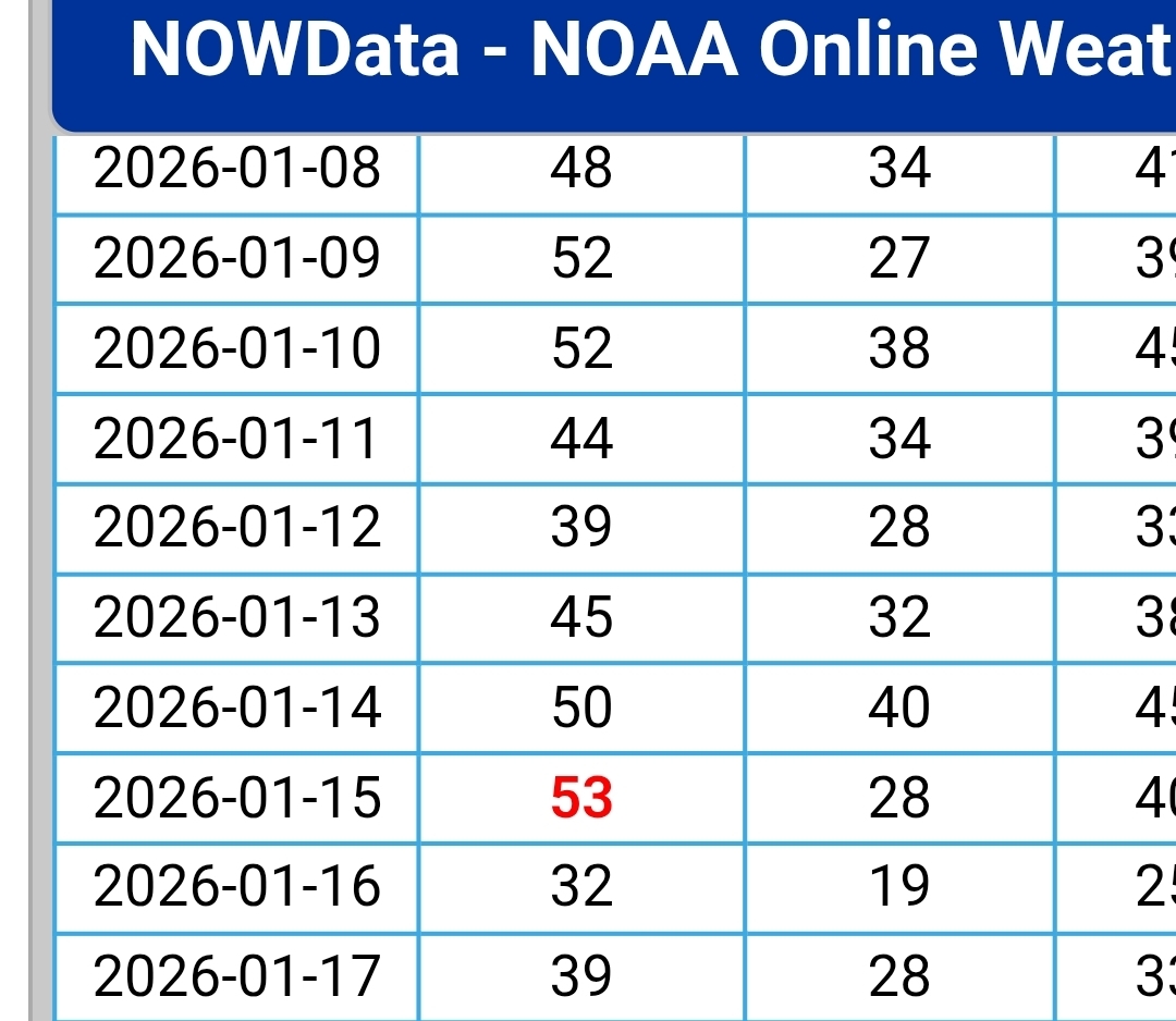
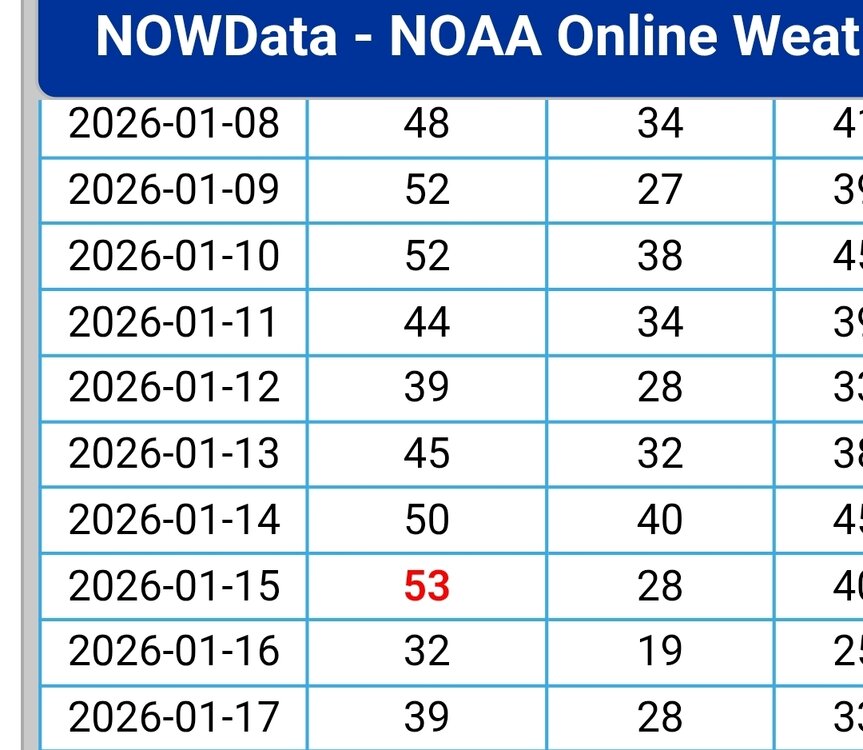
Wow…very impressive. So back on Wednesday the 21st…you guys didn’t go above 32? I think that’s the last day we did..when it started out in the single digits, but warned up to close to 40 that afternoon. Then it snowed that evening/night with a couple inches. But since then it hasn’t broke 32 here. So 13 days so far and counting. Quite the run for sure.
-
November huh?
-
You know ...I was giving that, that 'pre spring' aspect some thought. I know exactly what you mean as I have been seeing/wondering that too. However, I'm not sure if you or anyone might recall this but... nearing the end of that odd ball N. Pac blocking node between thanks giggedy and early early Jan, we were modeling something similar to this with periodic ultimately faux SE ridges ... We did mild up in there, but not very convincingly so before the era of -EPO kicked in. We've pulsed some 3 or 3.5 times with that index in the last 3 weeks since, and we've registered some decent wintry chill and at last a real snowfall out of it... Anyway, point is, I'm not sure this isn't some Charlie Brown set up for spring/warm enthusiasts just yet. I don't think there is a proper SSW intrusion --> down propagation event... but I think a low to up variant is certainly on the table, and it doesn't matter? really if you're doing that, your freezing your balls off either way... in fact, the top down version is probably less useful to winter enthusiasm ( just for the sake of discussion) because that time-lag's a killer going into March. It could just not show up when it is that late. But anyway, I definitely want to see some legs in the form of continuity in a warm appeal out there. Lord knows I want it... but just objectively
-
 Less cold this weekend helps because the snow has increased both pre and prior to it . Now that the low digs south it snows more, allows for the core cold to go west and we snow / ice next week with no suppression.
 -
lol... was easy enough to go look and see what happened... and I'm not even remotely surprised
-
You can clearly see the temps moderate after early next week on the ensembles but still plenty serviceable. Hopefully a return to more seasonable temps brings the snow back with it.
-
Excellent idea! If I only had water to make coffee or hot chocolate! But they will get the thanks for sure!
-
26 here currently here, after reaching a high of 30 today.
-
Friday February 6 FROPA / WINDEX small event
Damage In Tolland replied to HoarfrostHubb's topic in New England
When were you last right ? Asking for a weather forum -
The pattern definitely has potential and it’s cold and dry. However there will be a gradient that sets up. SNE can be on the warmer mix/rain side or seasonably cold and snowier side
-
Currently 33 after a high of 37 Bring me my dusting. Refresh my bourbon. Oh shit, I'll have to do that.
-

Is we back? February discussion thread
40/70 Benchmark replied to mahk_webstah's topic in New England
Coldest December-January combo in Boston since 2003-2004. -
Hudson River ice 2/3/26
-

February 2026 Medium/ Long Range Discussion: Buckle Up!
Chris78 replied to Weather Will's topic in Mid Atlantic
Don't know about the weird coastal but the overrunning looks totally plausible and a way we score alot of our low end warnings around these parts. 4 to 8 with some sleet/zr ending as drizzle -
Perfect. That’s what we want…moderated but perfect seasonal progression for peak snow climo.
-

Is we back? February discussion thread
Baroclinic Zone replied to mahk_webstah's topic in New England
Let’s just keep the pattern more active. Maybe it’s anecdotally but I fell we do better when temps aren’t as cold as this. -
I am. Still check on things from time to time. And winter is the silly season for our main break crews. They have to work in the worst conditions. A thank you and hot chocolate are always a nice way to say thanks.
-
WTTTE….they don’t want to listen. It’s been doing this since late November. It finds ways to stay colder, rather than not. Not hard to understand….its starting to show this yet again.
-

WxUSAF's weak ass frontal passage thing.
midatlanticweather replied to dailylurker's topic in Mid Atlantic
Having some nostalgia at the moment. This place has given me so many lols and also a lot of wisdom from the Mets and very wise posters. Winters mean more because of it. The hunt and chase can be very fun and rewarding (even if heartbreaking) at times. -
That rotting NAO block combined with loss of cross polar flow sort of just keeps the geopotential gradient lower over the region which may work to our advantage if that rotting block successfully prevents cutters (which it does on this GFS run and various other model runs)…if it’s able to do that, then we could get some decent looks. It’s also the “pre-spring” look…I’m sure you will get what I mean…it’s not quite the full blown spring look with very rapid seasonal recovery south of us…but it’s def not “deep winter” across the CONUS anymore. It’s the r type of loom where we can have -7C 850 ambient temp atmosphere but you are hitting 37-40F during the day. But as soon as a system comes in from the Ohio valley and is forced underneath, that 37-40F turns to snow event in the 20s to near 30F. It’s basically a slightly colder version of the blue bomb look in late March when we’re pimping -1C at 850 with high temps in the 50s, but as soon as a bowling ball hits that airmass, it’s 32F and parachutes.
-
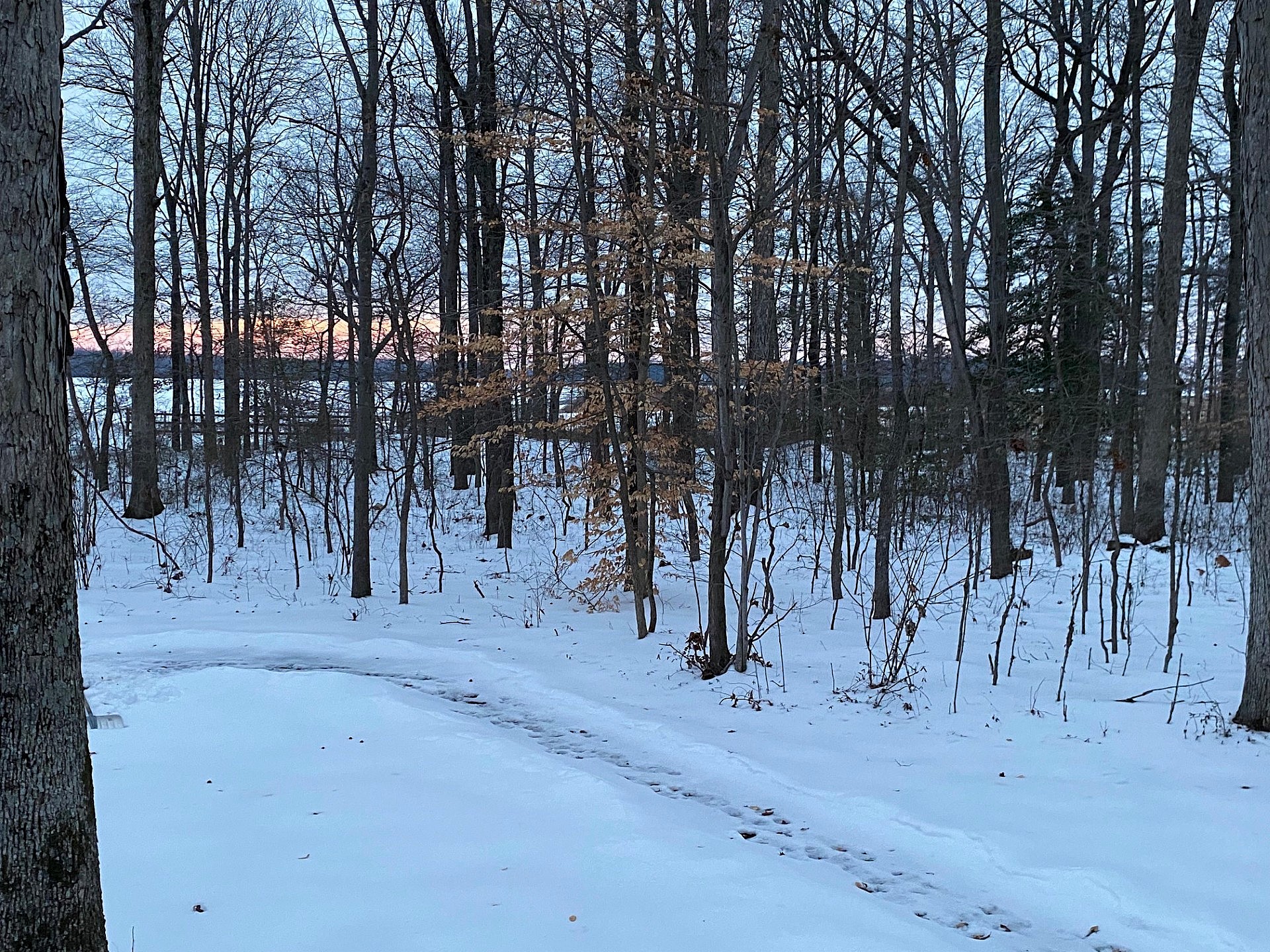
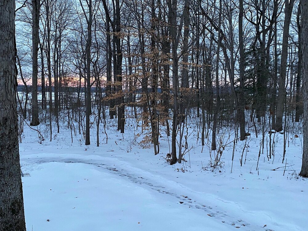
Cloud shrouded sunset. Still a deep winter look despite temps in the mid 30s with some meltage today. Hopefully a refresher is on the way.
-
 Probably down to 8” now. Melted just like your snow melted from the snow you didn’t get Sunday. My post said run of the mill arctic cold snap which is what it will be if 850 temps of -18 verify like the 18z GFS has. The -30 the GFS had a few runs ago would be much higher impact and record breaking. I also did say bitter wind chills with 30 to 40mph winds so not sure where the confusion is, we’ve had several shots of cold air recently this one will be much of the same with a bit more wind this time and hopefully some snow.
 -

February 2026 Medium/ Long Range Discussion: Buckle Up!
Climate175 replied to Weather Will's topic in Mid Atlantic
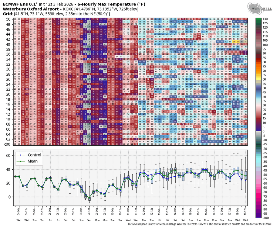
It’s longer-range, but the fact models are throwing that type of snowfall around Feb 14-17th period signals it’s worth the watch. As we all know, there are going to be numerous changes before we reach that date.