All Activity
- Past hour
-
yeah I am leaning more in the Danville direction for now. Worst case is I get wrecked on slots at Caesars.
-
We are cooked for a couple weeks at least. If we see anything this month it will have to be from Dec 19-31
-

2025-2026 Fall/Winter Mountain Thread
nchighcountrywx replied to Buckethead's topic in Southeastern States
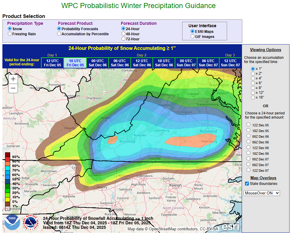
Good Morning. Referencing latest official guidance from WPC

-
Born Again is down by Danville. I think he does pretty well but Smith Mountain over to Roanoke looks like a pretty sweet spot to be. I’m like right on 81 just south of Roanoke myself.
-
Was about to post the same thing. Everything was white. 25.3 as my low this morning. The roll coaster continues into rain and mid 30’s tomorrow . [emoji1751] .
-

Central PA Fall Discussions and Obs
Jns2183 replied to ChescoWx's topic in Upstate New York/Pennsylvania
Storms seem to be missing South. Almost like the cold pushed the boundary to far Sent from my SM-S731U using Tapatalk -

December 2025 Short/Medium Range Forecast Thread
Carvers Gap replied to John1122's topic in Tennessee Valley
This pretty much sums it up...models are all still all over the place. National Weather Service Morristown TN 606 AM EST Thu Dec 4 2025 ...New AVIATION... .KEY MESSAGES... Updated at 601 AM EST Thu Dec 4 2025 Dry weather today before increasing precipitation chances tonight into Friday. - Probabilities for minor impacts from ice and snow are trending upwards across the northern Cumberland plateau, southwest VA and extreme northeast TN for tonight into Friday morning - Very low probability of rainfall this weekend. && .DISCUSSION... Issued at 1240 AM EST Thu Dec 4 2025 Dry today with continued below normal temperatures. Increasing precipitation chances tonight into Friday morning. The good news is that the latest HREF probs mostly align with the previous forecast. The bad news, the last two runs of the HRRR are well above the HREF means in terms of snowfall amounts. This makes for a low confidence forecast. Latest HREF guidance shows probs for at least 0.5 inches across southwest VA are in the 30 to 50% range. Probs for at least 0.5 inches for extreme northeast TN are generally from 50 to 70%. There are also low probs, 10 to 20%, of at least 0.5 inches across the northern Cumberland Plateau and areas along and near the TN/KY state line. Upping the prob amounts to 1 inch yield much lower values, around 30%, but for very isolated locations for both southwest VA and extreme northeast TN. The LREF members shows slightly higher prob values, and with more spatial coverage, for the 0.5 and 1 inch prob values. LREF shows moderate probs of 1 to 2 inches across southwest VA and into extreme northeast TN. The REFS output aligns fairly well with the LREF ensemble probs. Then we have the HRRR. The latest two runs of the HRRR show even higher values than what the REFS and LREF ensembles means suggests. The HRRR wants to paint a solid 2 inches in across the northern Plateau, and 3 to 4 inches in across southwest VA and extreme northeast TN. Because of all this, uncertainty in snowfall amounts is high. These higher end amounts would result in travel impacts while the lower HREF amounts suggest little to no impacts. With this forecast package, have trended snowfall amounts slightly upward, above NBM, based on latest model data and trends. In addition to the snow, NBM also painting in some light icing across these same areas. Please stay tuned to the forecast as the snowfall forecast will likely continue to change given the current variability. Please plan ahead for potential impacts with this system. Areas from Knoxville and south should remain all rain through the event. The bulk of the precip will have ended by Friday afternoon, but a few light showers may linger into the evening hours. NBM still wants to hold on to some slight chance POPs for Saturday and Sunday but it seems warranted so will leave them in the forecast. Rain chances continue into next week as an active pattern will be in place across the country. As of now, Tuesday look like it should be dry though and is most likely to be the nicest day of the forecast period. -
Snow, in general, is a miracle in the greater NYC metropolitan area...

-
Another super frost, prob the most accumulation I’ll see this week. Excited for my token sleet tomorrow and rain
-
we climbed the ladder but slipped on the last rung and fell on our face lol
-
If that’s correct, a cold look for sure. A coastal storm pattern, not so much (++NAO/flat PNA). Maybe fast moving, progressive clippers?
-
Got it! I didn’t realize Greenfield had a co-op now.
-
Well its 27 this morning and this time tomorrow it will be raining and 35
-
I’d go to @BornAgain13 backyard that looks like a good spot
-
Hey, the nam nailed Monday system! .
-
TWSS
-

December 2025 regional war/obs/disco thread
40/70 Benchmark replied to Torch Tiger's topic in New England
Yea, looks festive in my area...you can see it dwindle once I hit 495, and then scarce patches inside of 128. Must be all that elevation I have in them thar hills of Methuen. -

December 2025 regional war/obs/disco thread
Damage In Tolland replied to Torch Tiger's topic in New England
Just get me a GD inch -
The GFS is truly awful, this is probably the 6th or 7th time it has taken away the Sunday into Monday storm only to bring it back. Rain here, but ill chase it into NY.
-
Hey, at least you got the grass covered. I don’t really see anything until later next week and obviously that is questionable. But all the models hint at what I think is a decent look with some chances going forward. Probably nothing big although the GFS offered a coastal later in the run.
-
My other option is the Hanging Rock area north of Winston-Salem.
-
December 2025 regional war/obs/disco thread
40/70 Benchmark replied to Torch Tiger's topic in New England
Steve is a candidate to to get angered by that, too. My rule of thumb is if you are left equivocating with your schmenzer in your hand when asked exactly what you're tracking, then you aren't really tracking anything, and should expect nothing. -
8.0° drop here in an hour. 19.0 now.
-
Wild times breh
-
It’s really meh.


.thumb.png.4150b06c63a21f61052e47a612bf1818.png)


