All Activity
- Past hour
-

July 2025 Obs/Disco ... possible historic month for heat
kdxken replied to Typhoon Tip's topic in New England
It's not over. -
Yeah, the aerial coverage of the 850mb cold pool was among the smallest on record last winter. This is why that even though some of the coldest departures in the Northern Hemisphere were found in the CONUS, 2024-2025 was the 27th warmest winter at 34.07°. When we had much more expansive 850mb cold pools in the Northern Hemisphere back in the late 1970s, we had our coldest winter in 1978-1979 at 26.62°. The general observation has been the areas of the 500mb ridges have been expanding leaving smaller cold troughs. The late January 2025 Arctic outbreak in Baton Rouge LA and record snow was a great example of this recent phenomenon. Although they tied their all-time January low of 7°, the Arctic outbreak only lasted 3 days. They had a record high of 81° in early January and 83° in early February. So one of the more locally focused and limited Arctic outbreaks experienced in the CONUS. Overall January finished up at only the 25th coldest with a modest -3 cold departure against the warmest climate normals. Past occurrences of record snow and cold that far south was accompanied at times by historic cold and snow all the way to the East Coast which didn’t happen this time.
-
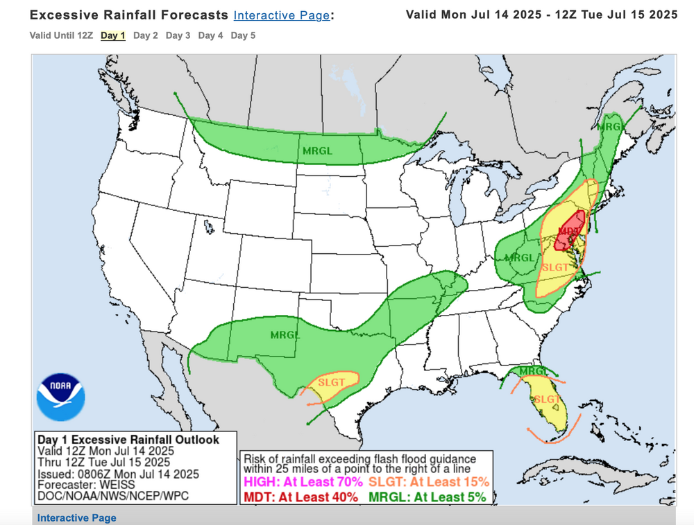
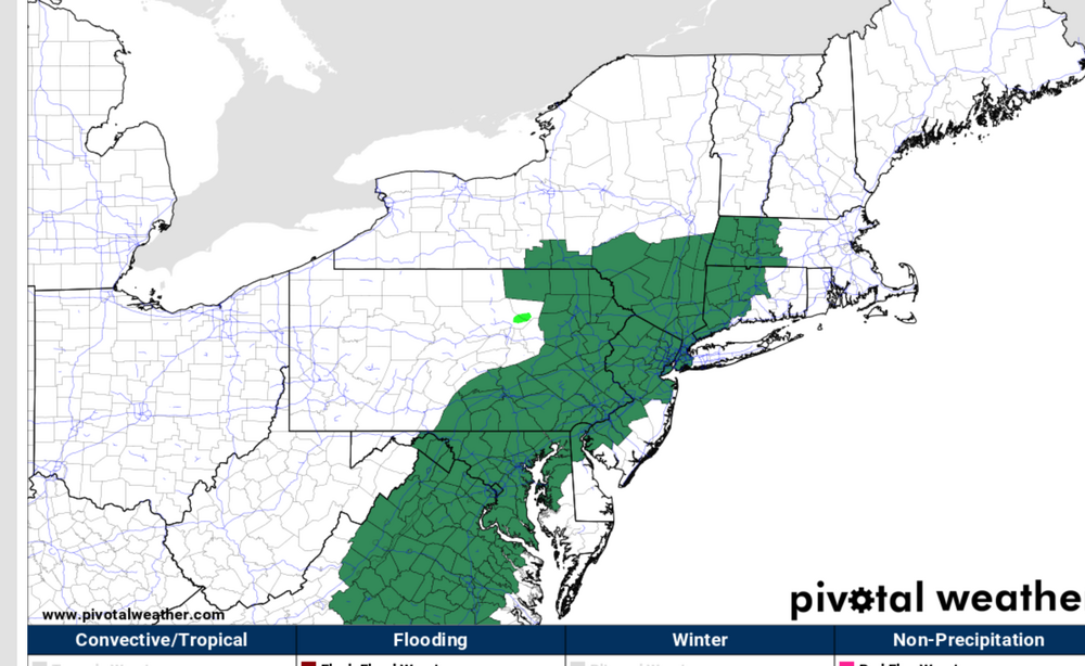
Weather Prediction Center has much of our area east of the Blue Ridge and north of Fredericksburg in a Moderate Risk for excessive rainfall today.
-
Yet another flood watch, meanwhile my yard is parched and the ground is hard as rock. 0.20 since July 2
- Today
-
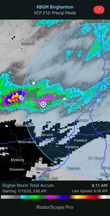
40 miles west of Scranton got 8" of rain last night Sent from my SM-G970U1 using Tapatalk
-

July 2025 Obs/Disco ... possible historic month for heat
dendrite replied to Typhoon Tip's topic in New England
Another ho-hum torched min. 68.3° -
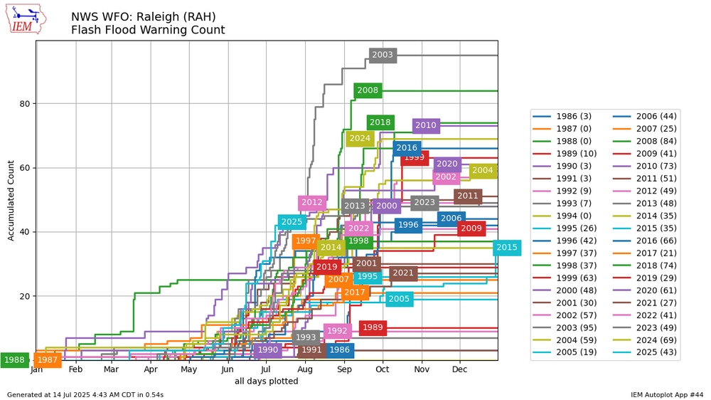
RAH has the highest flash flood warning count on record YTD
-
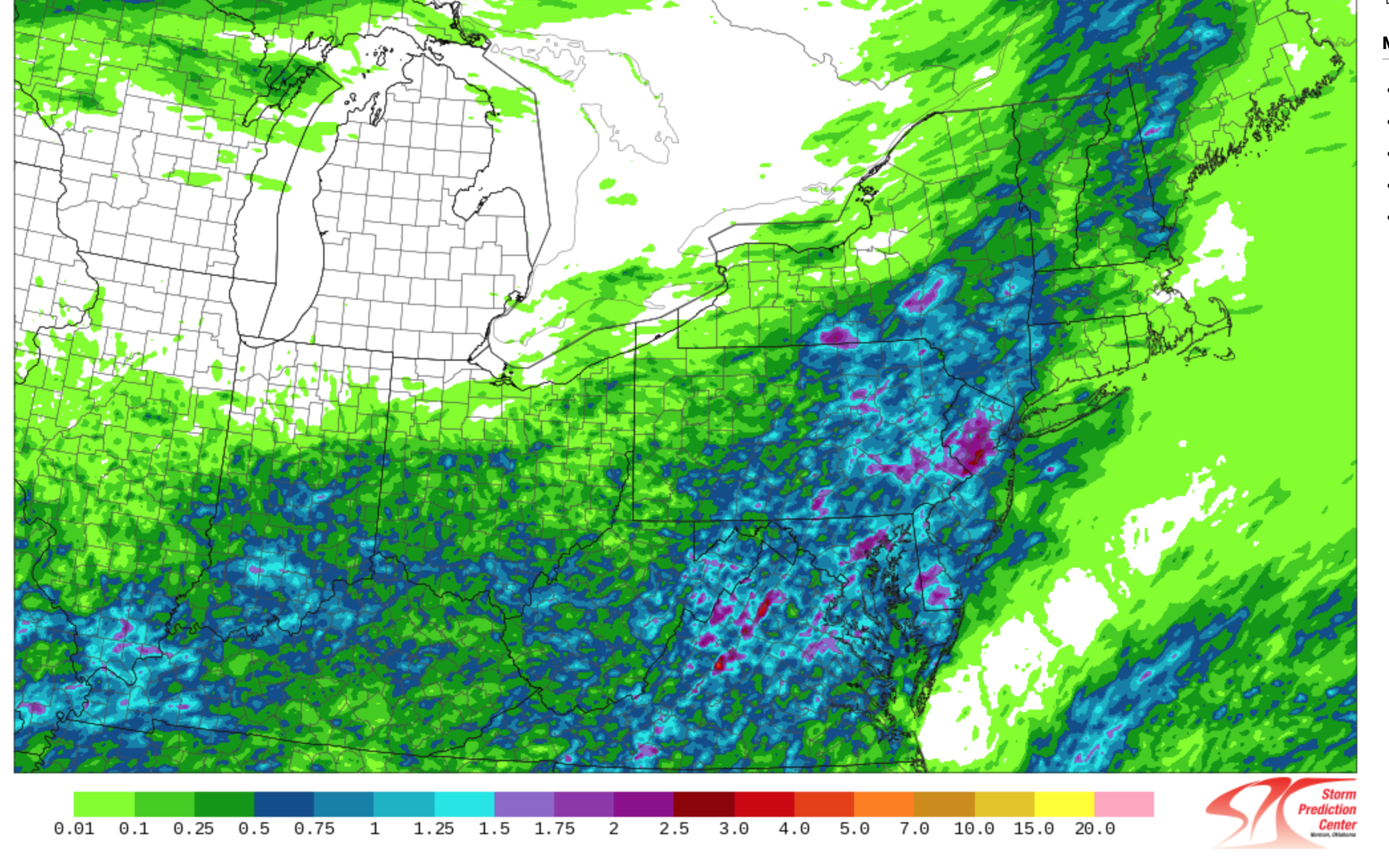
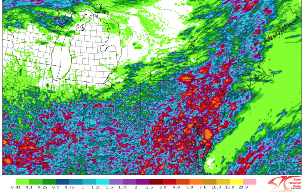
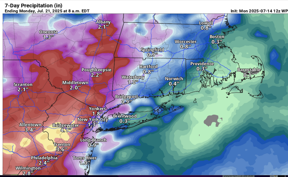
 Good Monday morning everyone. Please follow anticipated NWS warnings-statements later today. Already as of 530AM 1/4-1/2" amounts fell earlier today in NNJ. Watches are posted where potential exists for localized excessive rainfall by Tuesday morning, isolated 5-6" totals possible, mainly NJ portion of our NYC subforum. An impaired Monday evening commute is anticipated with delays-accidents-possible detours. Plan accordingly. Recent humid but no rain scenario of past several days limits any mainstream flood potential but creeks-small streams, and especially urban areas along I95 are vulnerable to short fuse excessive rainfall, life threatening flooding if caught in overflowed roads. Turn around-don't drown should be in the back of all motorists minds. Added SPC HREF average rainfall and maximum potential rainfall graphic by Tuesday evening (most of this occurring 2PM-Midnight today). The WPC excessive rainfall forecast. Also the 5AM WPC 7 day rainfall anticipated by the 21st and depiction of NWS watches lager today.
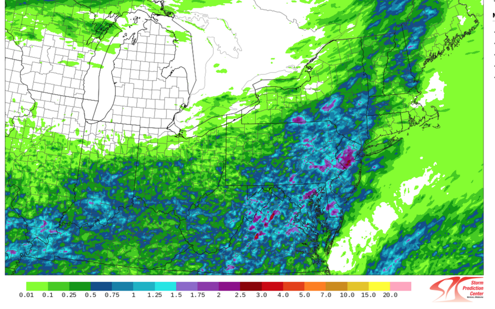
-
3K and HRRR seem locked in on an evening line of storms crossing the 95 corridor.
-
Pretty significant storms are forming and moving toward Kerrville. I do not want them to get that. Rescuers have operations ongoing there. I want that heavy rain in BUDA, now!
-
I fully regret eating those Texas peppers last night. I blame @canderson Sent from my SM-G970U1 using Tapatalk
-

July 2025 Discussion-OBS - seasonable summer variability
Snowlover11 replied to wdrag's topic in New York City Metro
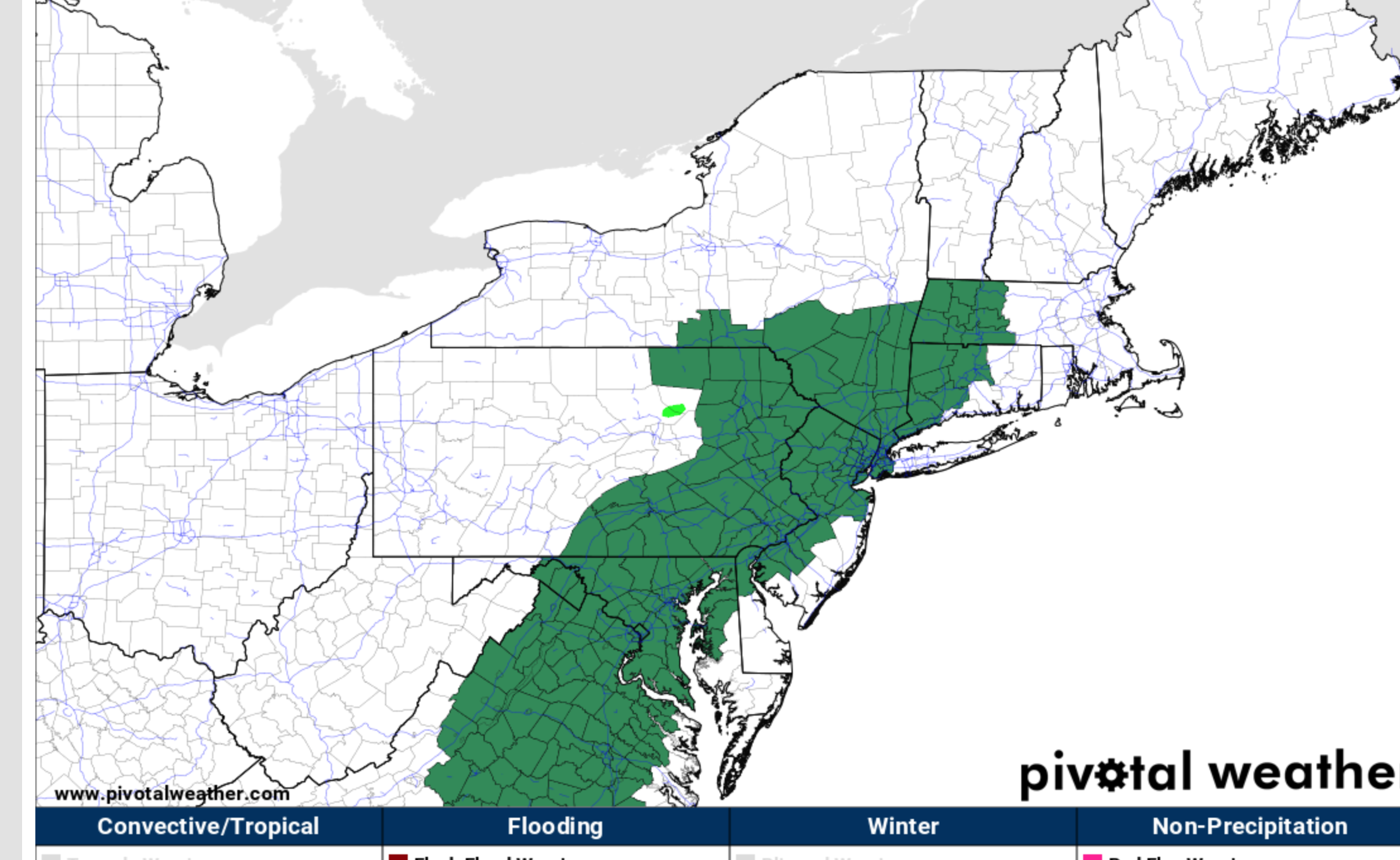
Flood Watch issued for everyone besides LI. 1-3” of rain with some picking up 3-5” of rain. Rates could reach 2+” an hour. -
 Up to 30%, and the ensembles are slightly more bullish today.
 -
You certainly did today. Hopefully you've just about caught up on the year rain wise now. I've been incredibly lucky that I've had rain so many days even if Im usually missing the big numbers. It's kept things lush and green. I'm not worried about ground water levels since I've been not far from some big numbers. I just find it amusing that I sut upon lush greens yet still am about 1.4" below normal. Sent from my SM-G970U1 using Tapatalk
-

July 2025 Obs/Disco ... possible historic month for heat
DavisStraight replied to Typhoon Tip's topic in New England
Probably the same insect. -
1.6” for the day. I won I think.
-
Between the morning and night I somehow managed 0.70". I'll take it. Maybe more tomorrow. I still find it amazing I'm more than an inch below normal on the year. Sent from my SM-G970U1 using Tapatalk
-
80/75 here.
-
Best weather ever! The dream is one day move there. Would have to be more inland to keep it semi-affordable. I just absolutely love that area. Have fun!
-

July 2025 Obs/Disco ... possible historic month for heat
Snowedin replied to Typhoon Tip's topic in New England
What’s crazy to me is they always seem to emerge from the exact same locations when you go by. It’s like they sit there in brush plotting and scheming how to ruin the next poor, unfortunate persons sweaty head that happens to walk by. Sometimes I really want to take a can of wd40 and a lighter and go to town on the bastards! -
65/59 in San Diego. Amazing.
-

July 2025 Obs/Disco ... possible historic month for heat
8611Blizz replied to Typhoon Tip's topic in New England
Cape beaches actually a little windy, but great compared to the stagnant air in other areas.
-
Surprisingly picked up 1.21 earlier today... From a cell in western Albemarle that started back building to the northern edge of Waynesboro... Usually that will happen in the southern part of town along or south of 64 with nothing up here...
-
I get all that, but radar was a lot of nothing today.
-
July 2025 Discussion-OBS - seasonable summer variability
Snowlover11 replied to wdrag's topic in New York City Metro
better get some rain tomorrow.