All Activity
- Past hour
-

Central PA Winter 25/26 Discussion and Obs
MAG5035 replied to MAG5035's topic in Upstate New York/Pennsylvania
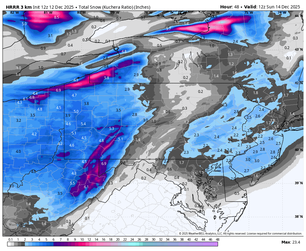
Here was latest extended run of the HRRR (12z) this morning The biggest thing to resolve in C-PA with this system is the extent of the snow shadow east of the Alleghenies. Pretty much all modelling shows this now to varying degrees basically in between the I-99/US220 corridor and the I-81 corridor. Models like the GFS or the 3k NAM don’t even give much snow to a large portions of the Sus Valley. The wave itself is fast moving and very weak with not a lot of moisture to work with. The mean flow in the low levels remains westerly, which is why you see such a pronounced downsloping shadow off the Alleghenies on modelling. So unfortunately I expect this feature to show up with likely a corridor of T-1” snows in the ridge and valley. How fast that precip shield reenhances as the weak system reaches to the coast will dictate how much of the Sus Valley can reach at least a low end advisory type snowfall. I think York/Lancaster probably does okay, not sure about the Harrisburg area (right now I’m thinking about an inch maybe two in that area). Obviously western PA doesn’t have to worry about the downsloping component and that coupled with this being plenty cold with pretty high ratios it should be a pretty nice event over there. Given the aforementioned low level westerly flow, that will act as an upslope component on the western leading ridges of the Laurels, which is why you see those higher warning totals show up there.
-

December 14th - Snow showers or Plowable snow?
CoastalWx replied to Sey-Mour Snow's topic in New England
12z euro AI very close to 6z. -
Beautiful. I’m gonna enjoy this one, until the next model shows zip for mby.
-

12/14: Sunday funday? Will the south win again?
paulythegun replied to TSSN+'s topic in Mid Atlantic
The 12z Frog Model looks good for the cities....just gotta hope for high ratios (0.5 inches of snow per millimeter)
-

Pittsburgh/Western PA WINTER ‘25/‘26
Rd9108 replied to Burghblizz's topic in Upstate New York/Pennsylvania
Yep the solution really hasnt changed much. A few wobbles north and south but overall it hasn't really changed. -
12/14: Sunday funday? Will the south win again?
paulythegun replied to TSSN+'s topic in Mid Atlantic
While we all wait for the 12z GEOS-5 model to run, here's the 00z GEOS-5 run for comparison.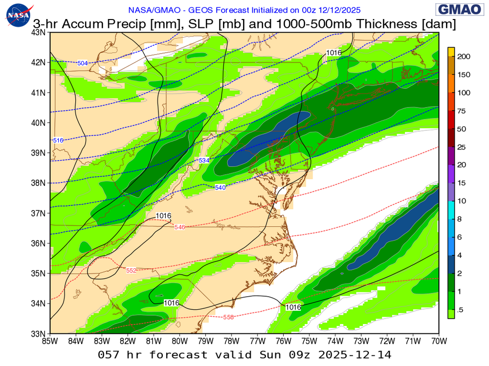
-
The models all show the PV retreating into Canada mid month and the polar jet with it. It’s not far which keeps Canada very cold so in Jan if we get a favorable pattern it won’t take much for it to come spilling back south, but we definitely warm up for a while in a pattern like that which looks zonal. It does promote high pressures over Quebec that could help in a SWFE situation but those are 90% of the time good for I-84 and north. Gradient patterns usually aren’t great for I-80/NYC unless we see something epic like 93-94. They’re a lot better for I-90 and north and that’s where New England that’s been skunked can catch up in a big way.
-
When winter used to be winter..60-61 was one of the great ones...
-

December 2025 regional war/obs/disco thread
weathafella replied to Torch Tiger's topic in New England
It was epic! I was in the 8th grade in NNJ and woke up Sunday 12/11 with “provisional heavy snow warning”. That was the precursor to today’s winter storm watch. But more importantly after a mega torch in the early days of December culminating in temperatures near 70 on 12/4. It was in the mid 40s on the 10th so imagine my surprise (and joy) to awaken to high clouds and 25. My mother made me sweep the garage that morning and for once I happily complied as I warded off the oak leaves blowing into the north facing garage. By the time I was done the temperature dropped into the low 20s. My Giants were playing Washington in DC and at the start of the broadcast the announcer exclaimed “we’re having a blizzard!” I remember one TD pass from YA Tittle to Del Shofner with Shofner ending up in a snow bank. It started snowing around 3pm and it was fairly light for the first 6 hours and I was starting to lose hope. Finally it started picking up and by time I fell asleep it was snowing pretty hard. I woke up at 5AM Monday and it was raging. Snow tapered off close to Noon. Temperatures during the meat of the storm were near 10. The storm paralyzed the megopolis. It was the first of 3 big ones that winter. The other 2 were the JFK inaugural storm and the widespread 2 footer February 3-4. The February storm was the pattern changer and winter was never the same that year but what a 2 month run! -
But 1988-89 was a mild winter just as well
-
ru drunk? or are you high because of the snow maps on your yard lol
-
was gonna say... this has been a great set of runs with the GFS finally budging a bit, but that just means we could be set up for a vintage Dr. No moment
-

Pittsburgh/Western PA WINTER ‘25/‘26
Burghblizz replied to Burghblizz's topic in Upstate New York/Pennsylvania
I think the other thing - not a lot to “track” per se. Just a clipper with decent potential due to ratios and banding. -
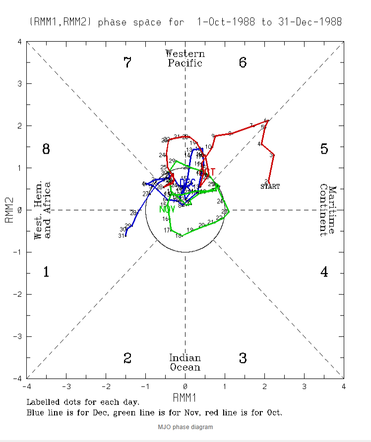
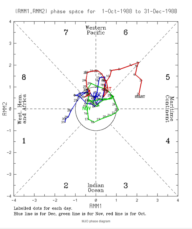
Since the models showed 1988,went back to look at the MJO IN 1988,it did some weird shit also,but this was a strong NINA unlike this year,no worries Jeff,i dont share anything here on this board unless you say i can
-
Yyyeeeeaaahhjj baby Watch the euro zig while all other guidance zags and totally shit the bed
-
We will definitely warm up but it might not be long lasting.
-
Bears game will be cold but temps in low teens and wind chill around 0? That’s probably an every few years occurrence (if not more frequent) in the NFL between there, Lambeau Field, Arrowhead, etc. .
-
We had some pretty flakes in west Cary.
-
Happy for you N/W folks! Also, happy that we have a variety of outdoor camera brands that now provide this kind of on-the-spot coverage...
-
Today a coalition of DC Snow Enjoyers announced a plan to curtail the down sloping effect by LEVELING THE BLUE RIDGE MOUNTAINS. In order to preserve cold air damming (when needed), the mountains will be replaced with a retractable CAD wall. We are not asking for public funding for this project. All we ask is for exclusive rights to develop a mixed-use, walkable community atop the Great Appalachian CAD Wall.
-
Natural gas is down still another 3% on the day, which brings the total drop since the peak of 8 days ago to a very steep 25% on an anticipated much warmer E US pattern (though maybe not to a torch in the means as I stated in my prior post) starting mid to late next week and continuing for the foreseeable future! At least that’s some good news for future heating bills. @Stormchaserchuck1
-
Back to cold now for Christmas Eve and Christmas Day on the GFS
-
Cool to see several reports around or even over an inch of snow from yesterday's snow showers in Morris, Warren, and Sussex counties. That made two days in a row of accumulating snow for the higher elevations. https://forecast.weather.gov/product.php?site=NWS&product=PNS&issuedby=PHI This was pretty well modeled.
-
and those gradient patterns are better for upstate NY and central/northern NE. 93-94 is an exception when the gradient was south of NYC
-

Pittsburgh/Western PA WINTER ‘25/‘26
Ecanem replied to Burghblizz's topic in Upstate New York/Pennsylvania
We’re not used to snow before Christmas. I think I golfed this week last year