All Activity
- Past hour
-

Septorcher 2026 Discussion - Endless Summer
40/70 Benchmark replied to Damage In Tolland's topic in New England
I don't think the fast flow will be a large issue this year. -

Septorcher 2026 Discussion - Endless Summer
WxWatcher007 replied to Damage In Tolland's topic in New England
That's where my head is at too. I was once ready to totally write off winter, but I think AN precip while we struggle with the battle zone for temps in southern and maybe central NE is going to be the theme of the season. And that can work out very well, but I'm guessing we need less of that fast flow crap and more active STJ. Problem with the stalled front is that way more often than not they just carry whatever develops OTS. Speaking my language. Hybrid would work just fine. -

2026 Mid-Atlantic Severe Storm General Discussion
midatlanticweather replied to Kmlwx's topic in Mid Atlantic
The stuff in PA does look like it could target the area again. Not sure it will be severe. -
It's been a while since we had one and the last few attempts didn't work out. I started the dates around mid-October since early October probably is too short notice (and selfishly I'll be away the first weekend of October and presenting at TriState Weather Conference the following week). I am hoping with some advanced lead time we can get a good gathering. I know November/December will also be difficult with holidays and I didn't put Halloween as an option as those with kids will probably be out getting candy.
-

2026 Mid-Atlantic Severe Storm General Discussion
SomeguyfromTakomaPark replied to Kmlwx's topic in Mid Atlantic
Storm woke me up, sounded like the end of the world out there. Lots of debris hitting my roof. Saw a few big trees down in DC on 14th street on the way to work. -
Day in and day out. Having a really hard time with holding onto elevated convection in setups like this. Decent instability gradient for them to ride down and shear improves this afternoon, so there's at least some chance this stuff makes it.
- 2,537 replies
-
- 1
-

-
- severe
- thunderstorms
- (and 7 more)
-
96 at 11:30…. On pace for our hottest day of the year
-
Much more moisture available today, along with the warmer climate.
-

E PA/NJ/DE Summer 2026 Obs/Discussion
Birds~69 replied to PhiEaglesfan712's topic in Philadelphia Region
DP 74F is the real problem... -
I've read a bit on that event. That was some serious stuff in terms of global impact, particularly to the fishing industry and ocean life.
-
 mexico online pharmacy or farmacias mexicanas farmacia mexicana en chicago https://www.google.co.ve/url?sa=t&url=https://mexiph.com mexican pharmacies online drugs and https://virtualchemicalsales.ca/user/mcqtdwkfia/?um_action=edit best mexican pharmacy online [url=http://bobm.allabouthoneymoons.com/Redirect.aspx?destination=http://mexiph.com]good online mexican pharmacy[/url] best online mexican pharmacy and [url=http://clubdetenisalbatera.es/user/orzzwvhvrf/]mexican drugstore[/url] mexico medication
 -
12z mesos want to kill it
- 2,537 replies
-
- 1
-

-
- severe
- thunderstorms
- (and 7 more)
-
I will say that the 1877 event was pretty similar to this and that winter sucked.
-
Area Forecast Discussion National Weather Service Baltimore MD/Washington DC 1052 AM EDT Fri Sep 4 2026 .WHAT HAS CHANGED... No wholesale changes to the forecast this morning. Monitoring convection upstream over Ohio (again) as that is on pace to affect the region with a damaging/severe wind threat later this afternoon into this evening.
-
Well said. And like Scott was saying, you do need to be careful with just applying linear logic of just taking previous strong EL Nino events and "energizing them". We very well may see a winter which does not match well at all with any of the previous stronger events. Reason for this is our database on those is so small and they're so infrequent that there are scenarios that just have not occurred. I mean look at what's happened to how our understanding of ENSO has changed even in the last 20 years and this is because as the datasets grow we introduce more possibilities and outcomes.
-

2026-2027 Record-breaking El Nino
GaWx replied to Stormchaserchuck1's topic in Weather Forecasting and Discussion
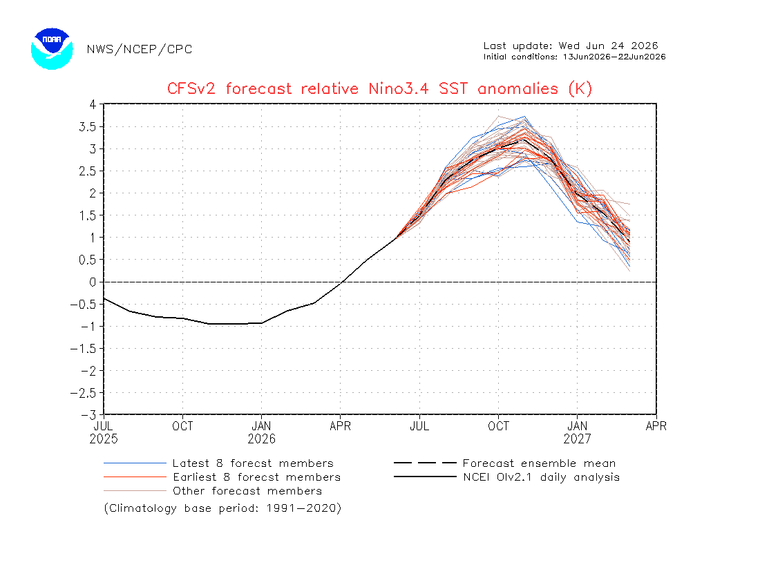
Consistent with OISST, the August relative ERSST anomaly for Nino 3.4 just came out and it also shows a rather mundane warming in August vs July compared to the near record breaking rapid warming of ~1C that several models had been showing. The Nino 3.4 anomaly warmed by only 0.34: 2026 6 1.07 2026 7 1.33 2026 8 1.67 It had been earlier progged to be >+2 for August. For example, check out this June 13-22 mean CFSv2 prog for August: +2.3, which was notably above what verified: How does August of ‘26 compare to other very warm Nino Augusts since 1950? It’s very warm but still wasn’t the warmest as 1997 was 0.18 warmer. Had it warmed to +2+ like had been progged, August would have easily been the warmest on record: 2026 +1.67 2015 +1.58 1997 +1.85 1987 +1.27 1982 +0.93 1972 +1.47 1965 +1.57 1957 +1.36 https://www.cpc.ncep.noaa.gov/data/indices/Rnino34.ascii.txt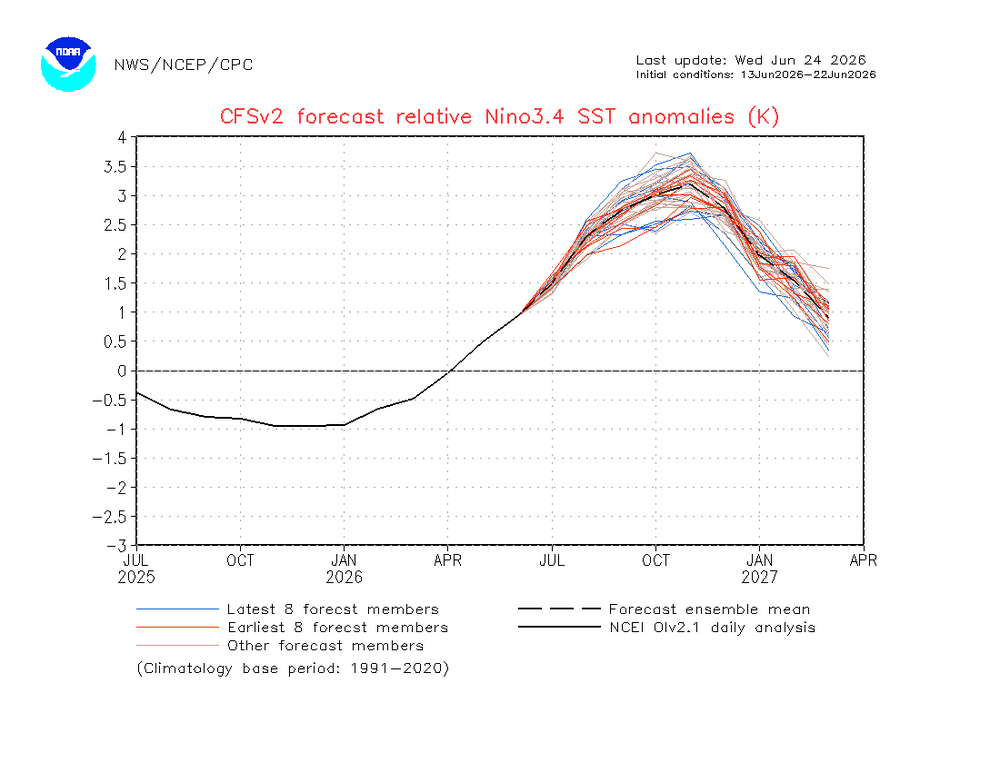
-
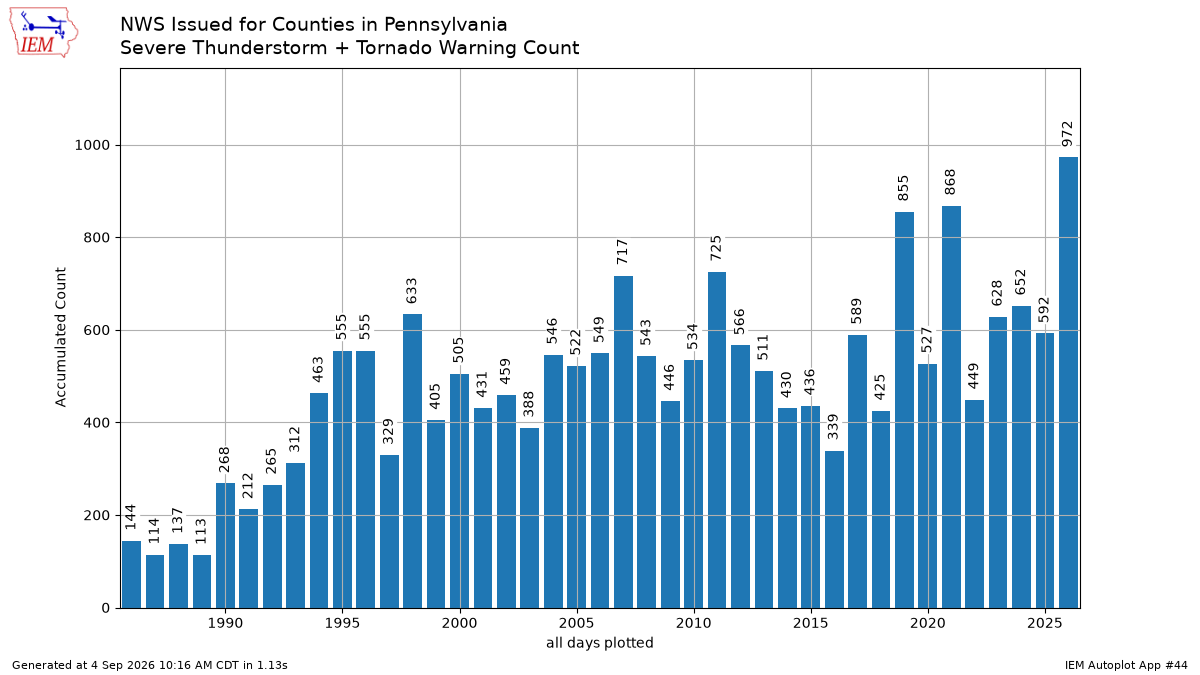
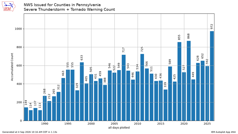
Record number of tornado and severe thunderstorm warnings for PA this year. https://mesonet.agron.iastate.edu/plotting/auto/?_wait=no&q=44&plot=bar&opt=state&station=DMX&state=PA&fema=7&limit=no&c=svrtor&phenomena=TO&significance=W&syear=1986&eyear=2026&s=jan1&_r=t&dpi=100&_fmt=png
-
Septorcher 2026 Discussion - Endless Summer
40/70 Benchmark replied to Damage In Tolland's topic in New England
I don't see why it would be displaced southward...agree on northward. -
Septorcher 2026 Discussion - Endless Summer
40/70 Benchmark replied to Damage In Tolland's topic in New England
Sorry for OT...honestly forgot which thread I was in. -
Region 4 has kind of dried up for now, but I don't think that wil last.
-
Shit....I forgot I was in the Sept. thread...my bad. I early hunch on how the unprecedented magnitude of ENSO will factor in is one word...VOLATILITY. When you have those type of anomalies throughout the basin, it's going to introduce a myriad of different forcing schemes along with a very prominent and loaded STJ.....line it all up nicely, and the sky is the limit....but don't blink, or it will melt and you'll miss it.
-

Septorcher 2026 Discussion - Endless Summer
Cyclone-68 replied to Damage In Tolland's topic in New England
It looks like someone smashed someones Lego’s? -

Septorcher 2026 Discussion - Endless Summer
weatherwiz replied to Damage In Tolland's topic in New England
The size of the +28C to +29C water temperatures within the Tropical Pacific is ridiculous. Even +20C off Mexico and into the Baja. -
90 at 10AM
-
Septorcher 2026 Discussion - Endless Summer
weatherwiz replied to Damage In Tolland's topic in New England
Adding on to my reply to Scott in your winter thread about the ridiculous graphic from the annoying guy and how some of the stuff he says doesn't seem to make sense. He is favoring increased winter threats in the deep South because the jet will be shifted south. I don't think that is totally true but I do know alot of generic stuff out there on EL Nino mentions this. I think there seems to be confusion out there on the different branches of the jet stream. The cooler/wetter patterns which plague the southern states during EL Nino I think is related a a stronger jet (which we all know) but its a stronger sub-tropical jet stream which can have the tendency to be displaced a bit further NORTH and its the cooler/more active track which plays a bigger role in the temperature anomalies. But its the stronger jet which is more critical versus the displacement. The polar jet also tends to be displaced further north, hence the lack of Arctic cold outbreaks penetrating south.