All Activity
- Past hour
-
Stupid. Just another OF in an already crowded outfield. I know Grayson has been hurt but never trade away quality pitching. They better do something about the starting pitching in the offseason.
-
You are really lucky to be living in such a beautiful region. The stronger winds and lack of ideal radiational cooling there are also a function of the warmer air masses in nearby Canada. Since really cold Arctic air masses usually begin with strong cold air advection followed by a few nights of high pressure and calm clear nights behind the Arctic fronts leading to the great radiational cooling. We haven’t been getting this cold pattern in the Northeast with Canada so warm. The Northeast needs good cold pooling near Hudson Bay which has become more rare over time. The airport station that was established in June 1998. It’s in a uniquely cold area with excellent cold air drainage. So it can be 10 to 15 degrees cooler than the village. But that microclimate is still a good proxy since it is currently experiencing its 2nd longest streak not dropping to -30 or colder. The Number #1 longest streak was several years ago. Number of Consecutive Days Min Temperature >= -30 for SARANAC LAKE ADIRONDACK REGIONAL AP, NY Click column heading to sort ascending, click again to sort descending. Period of record: 1998-06-06 1 1103 2019-01-14 through 2022-01-20 2 1018 2023-02-05 through 2025-11-18 3 524 2000-10-31 through 2002-04-07 4 460 2007-03-08 through 2008-06-09 5 399 2011-01-25 through 2012-02-27 6 353 2016-06-30 through 2017-06-17 7 341 2004-02-21 through 2005-01-26 8 329 2012-03-01 through 2013-01-23 9 326 2013-02-21 through 2014-01-12 - 326 2010-01-12 through 2010-12-03 https://www.northcountrypublicradio.org/news/story/21443/20130218/why-lake-clear-is-so-very-cold Feb 18, 2013 — The village of Saranac Lake has a reputation for cold. During the winter, it's frequently the coldest spot on the North Country weather map, sometimes the coldest in the lower 48 states. Overnight or early morning temperatures in January can hit 20 and sometimes 30 degrees below zero Fahrenheit. That kind of cold is has brought the community a fair share of publicity over the years, but technically, that publicity should go to another community located about five miles outside of Saranac Lake: the hamlet of Lake Clear. Watch the nightly forecast from WPTZ weatherman Tom Messner and you'll find Saranac Lake is often the coldest spot on the map. But that's actually not Saranac Lake's temperature. The reading Messner and other forecasters are giving is recorded at the National Weather Service automated weather station at the Adirondack Regional Airport in Lake Clear. It's typically much colder there than it is in a short distance away in the village of Saranac Lake - sometimes as much as 10 to 15 degrees colder. Enterprise Sometimes the airport temperature is significantly colder than it is just a mile-and-a-half down the road in the hamlet of Lake Clear, where Bob Callaghan lives. The same morning in mid-January that the airport weather station hit 31 below, Callaghan said he had minus 21 at his house. "The thermometer in the car definitely registers colder when we get in the area of the airport," Callaghan said. "Sometimes it's 10 degrees difference." Why is it so much colder near the airport? What strange weather phenomenon is at work here? Dave Werner started asking that question a few years ago. Werner lives in Malone and is a cooperative observer for the National Weather Service. "Every day I'd compare my readings with all of upstate New York and Vermont," he said. "And it was so interesting to me that Saranac Lake [Lake Clear] was so much colder than every other place." In 2008, Werner contacted the weather service's Burlington office and got an explanation. "It's called cold air drainage," Werner said. "The bowl-shaped terrain around the Lake Clear airport is such that cold air settles or drains into the airport area, giving it significantly colder readings than are found in the village of Saranac Lake." John Goff is a meteorologist with the National Weather Service in Burlington. He says Lake Clear is higher up, "and it's an open area, an open kind of clear area at the top of a hill where the cool air can kind of just pool." For people who live and work in Lake Clear, the bitter cold winter temperatures brought on by this microclimate are just a fact of life. Deb Gauthier is the Lake Clear postmaster: "It was minus 31 yesterday. When I went out at lunch time it was minus 21. You don't go out with wet hair, and you bundle up. We live with it." Surprisingly, the arctic temperatures cause few headaches at the airport, according to its manager Corey Hurwitch. "Just our equipment sometimes starting up is a little more difficult in the morning," he said.
-
.18"
-
Snow by me was only sticking to non paved surfaces and roofs. The R/S line at least along the rt. 23 corridor was at rt. 287. Currently raining in Westwood NJ.
-
 Same here (22.5 for MPM). Coldest of the season.
 -

E PA/NJ/DE Autumn 2025 Obs/Discussion
Hurricane Agnes replied to PhiEaglesfan712's topic in Philadelphia Region
I finally caved and put my heat on last Tuesday and at least I got a few days before the indoor humidity crashed to 22%. Needless to say, the humidifiers were fired up yesterday afternoon and and overnight, and I'm finally @35% (with the rain helping). Had my first frozen of the season yesterday. About 3:15 pm, my Upper Darby sis had texted "And now it's sleeting". I hopped up and looked out and didn't see anything except some possible drizzle (it was in the mid-40s at the time). But about 15 minutes later I checked and heard the unmistakable pingers. Obviously nothing was sticking but it was there. Eventually it became a mix of light rain and sleet. Ended up with 0.01" of that yesterday and woke up to 0.20" this morning. After a 32 low yesterday morning, made it up to 47 and it's currently 39 with light rain (now at 0.32" in the bucket), and dp 38. -
Agreed, just some flurries here.
-
For the MA, phase 7 is a transition phase. It is usually the precursor to big storms. Not always, but some.
-
Wow. Not sure about this.
-
0.27"
-
0.35"
-

Central PA Fall Discussions and Obs
mahantango#1 replied to ChescoWx's topic in Upstate New York/Pennsylvania
Rain and big wet snowflakes here 34 degrees. -
FWIW, Judah updated his SPV blog for anyone interested:
-
Flurries/on and off snow showers in Sloatsburg. Nothing sticking anywhere. 35 degrees
-
Interesting trade for the Os. Dropping injury prone Grayson for an outfielder, Taylor Ward, with power. Ward has 61 HRs and 178 RBIs in the last two seasons. Meanwhile, Grayson hasn’t pitched since July 2024. One can hope this means the Os will be aggressive with getting pitching help.
- Today
-

Central PA Fall Discussions and Obs
Voyager replied to ChescoWx's topic in Upstate New York/Pennsylvania
Yup. Snowing in Tamaqua and Hazleton. I had a hell of a ride just to get to the truck. Quarter sized flakes and a Jeep with recessed LED lights meant that they caked up with snow. I got the "star wars" effect, but I couldn't see the road worth a damn... -
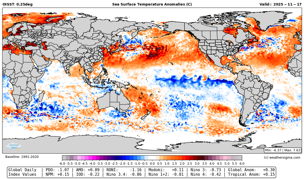
A lot has changed in the last month. Waters have cooled east of Japan and warmed in the east Pacific, a trend likely to continue. The PDO by my calculations is closing in on -1, and should rise further with this pattern. The -IO has collapsed. With some decent cooling near the MC, hopefully limiting MJO 4-6 this winter. The +AMO is strengthening but with a tripole pattern. RONI remains below -1. Global temperature anomalies dropped another 0.1 C in the last month.
-
Oh look the classic warm/wet to cold/dry and vice versa pattern. SE ridge comes back every time
-

Central PA Fall Discussions and Obs
MAG5035 replied to ChescoWx's topic in Upstate New York/Pennsylvania
I just woke up right as this was ending here and have a half inch on the ground and slushy roads. Def a bit of a surprise as it was only supposed to be maybe a rain/snow mix here at best. Can see snow or snowing on the 511 cams down to at least Mifflintown. At any rate on the board with the first measurable of the new season here. -
@sussexcountyobs @wdrag Let me know if things start to pick up with the stuff coming in from the west.
-

Central PA Fall Discussions and Obs
Jns2183 replied to ChescoWx's topic in Upstate New York/Pennsylvania
Somebody has to be seeing snow from this. It's 32 up in Perry County Sent from my SM-G970U1 using Tapatalk -
Snow level is quite high in the Poconos early this morning. Looks like you have to be at least 1500’ up to see steady snow currently and even there it’s difficult to find it sticking anywhere. Places lower than that don’t look to see more than a mix at times.
-
Light snow. 33.3
-

November 2025 general discussions and probable topic derailings ...
Modfan2 replied to Typhoon Tip's topic in New England
Down to 23F here in the Valley, coldest of the season. -
I've seen an ice pellet report via MPING over sw Long Island at 320AM. Mixed rain/sleet NYC area with possibly a few wet flakes for the Bronx by the time 7AM rolls around.