All Activity
- Past hour
-
I’ll lose my mind if this is a miller b and nyc gets a foot
-

E PA/NJ/DE Winter 2025-26 Obs/Discussion
Duca892 replied to LVblizzard's topic in Philadelphia Region
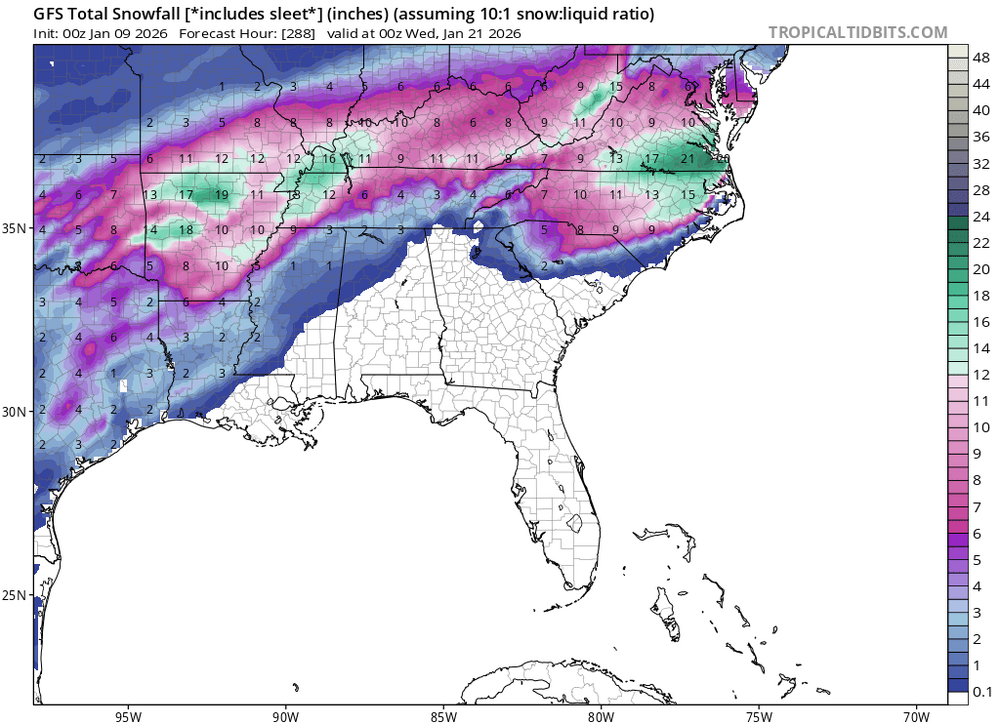
GFS is really really really trying for next week…. -
6z Gfs hasn't given up on 15th/17th. Not huge but snow.
-
Would be nice for I95, but still to far out, we have a current rain storm coming in this weekend. Than a short live cold spell with snow shower before temps rise into the 40s. This according ti the 10 day weather forecast for Felton Delaware
-
6z GFS next Thursday

-
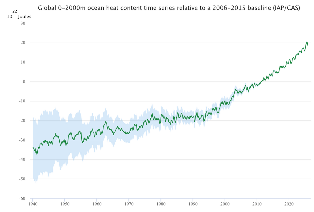
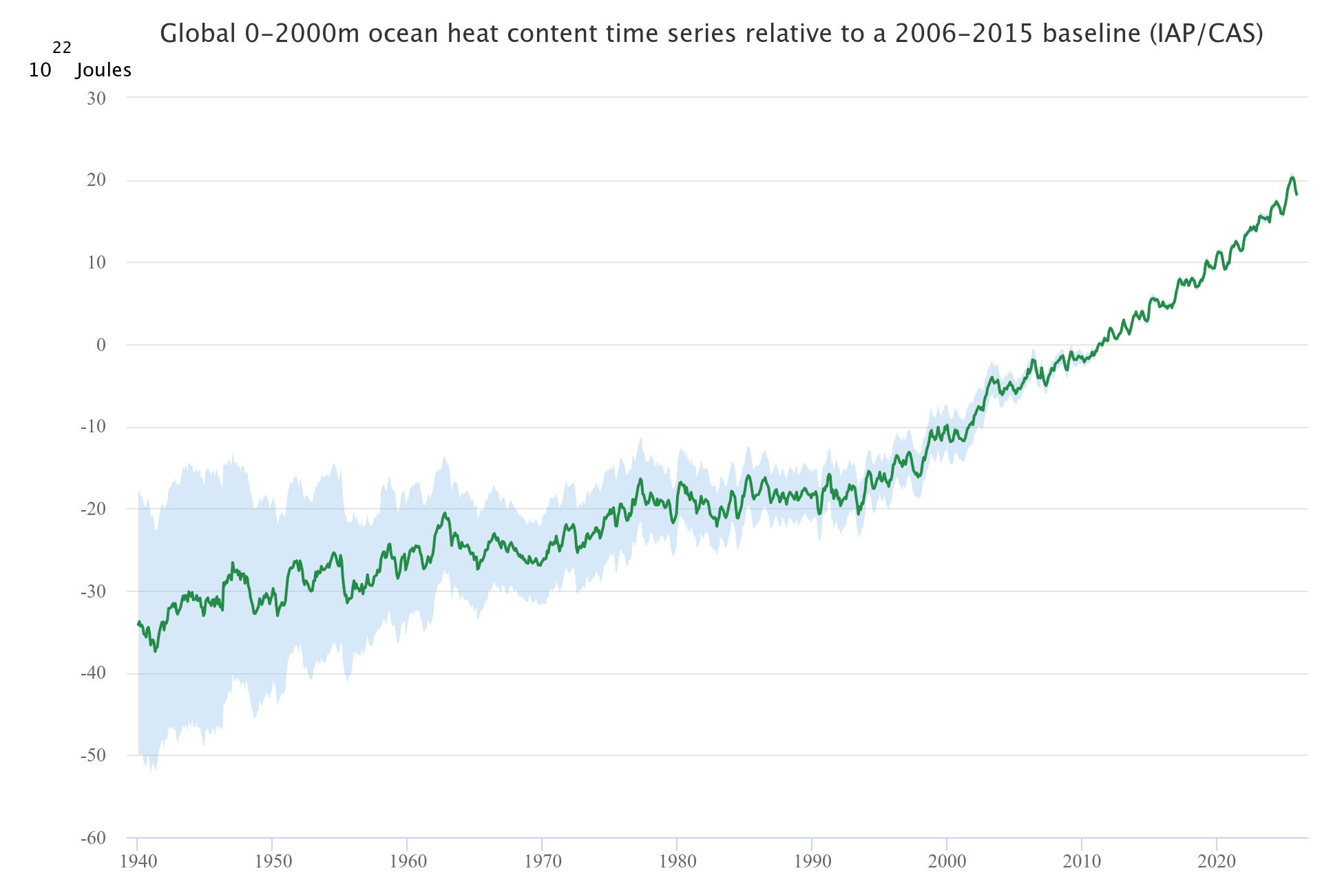
Large increase in 0-2000m ocean heat content last year. NOAA data through mid-year also shows a large increase.
-

January 2026 regional war/obs/disco thread
CoastalWx replied to Baroclinic Zone's topic in New England
Big uns on guidance last night. We pray. -
6z GFS phases late to give light snow to NC/VA next Thursday
-
End of 6z ICON looks like it could be close to phasing.
- Today
-
Both 0z Euro and GFS liked the period around the 19th
-
For the mountains. Both Euro and GEFS snowfall means ticked up for most in Carolina’s with the overnight suite. Both systems have potential here and we’re seeing solid miller A potential from both. GFS evolution was wonky to me, digging energy into the SW and holding it back. Would be great for overrunning but everything seems to trend more progressive with time. Euro is amped and a legit miller A with the second storm. First storm is soooo close across guidance just not quite there on anything
-

E PA/NJ/DE Winter 2025-26 Obs/Discussion
Birds~69 replied to LVblizzard's topic in Philadelphia Region
Same here. And there was about a hundred or so pecking at the grass on a baseball field at a local high school. -

2025-2026 ENSO
so_whats_happening replied to 40/70 Benchmark's topic in Weather Forecasting and Discussion
What an interesting pattern the 00z GFS showed up to 240hrs @ 10mb The 500mb maps were also very interesting, of course one run but don't think I have seen tropo/strato connection in this way with multiple 500mb lobes developing especially one still sitting in the Beaufort Sea/ CAA before. This would probably be considered a minor wave 2 event but not a whole lot of warming taking place which is something that is lacking in completely taking down the SPV..thumb.gif.6656e0906b0c1bff398c0c7187cf4c5d.gif)
-

January 2026 regional war/obs/disco thread
Torch Tiger replied to Baroclinic Zone's topic in New England
Euro AI likes the 18th. Big 'un -
Euro was a beaut.
-
A week of warm weather but winter is back on next week.
-

January 2026 regional war/obs/disco thread
brooklynwx99 replied to Baroclinic Zone's topic in New England
we trend.thumb.gif.ca14681367f3553649077e5a1ce7a59c.gif)
-
Love the fantasy storms.
-
Cannot sleep tonight.
-
Still kinda like this one
-
Are you a grief counselor?.
-

January 2026 Medium/Long Range Discussion
Stormchaserchuck1 replied to snowfan's topic in Mid Atlantic
Kind of looks progressive.. I'd rather have it backed up with a gulf of alaska low and 50/50 low. trough dropping in the upper midwest might shear the thing out. -
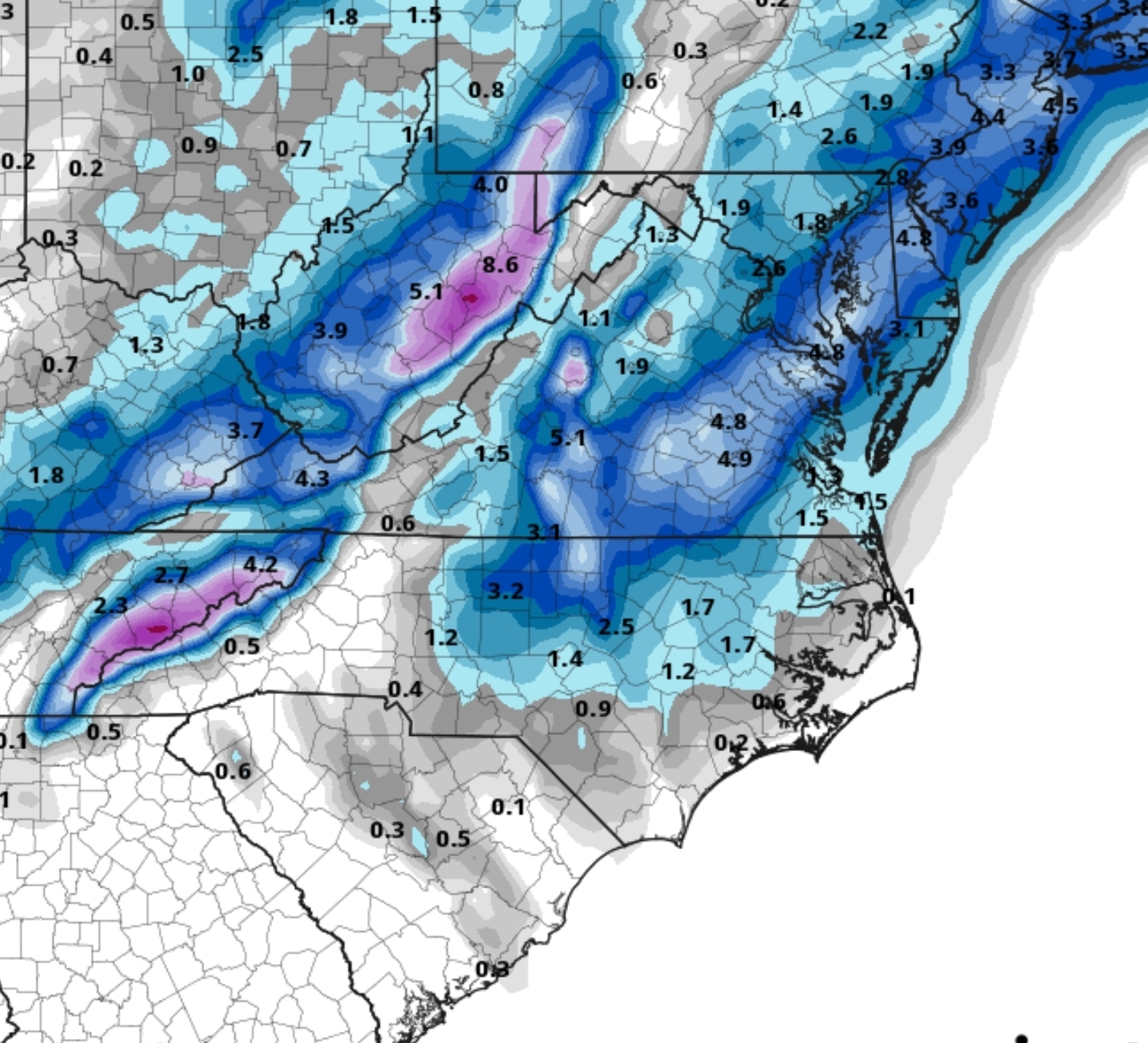
This is two systems, a light one (heavy in the mountains) around D6/7 and the other around D9/10.
-
January 2026 Medium/Long Range Discussion
Stormchaserchuck1 replied to snowfan's topic in Mid Atlantic
We're losing the cold pattern on the 500mb! -EPO patterns are too short lived, they retrograde a low pressure backs in a lot of the time. Still far out to go, and there are a lot of fundamentals saying more +PNA for that time, so maybe the model doesn't verify. -
The Euro AI has the same footprint but much drier. I've noticed the Euro Ai last year was always the driest model, and the AI GFS is also drier than the OP models.


.gif.0d0706d840113a9e2f09addcdc8a5351.gif)


.gif.42ab505b322ce9937f4b4cf46ae88126.gif)