All Activity
- Past hour
-

First Winter Storm to kickoff 2025-26 Winter season
Ginx snewx replied to Baroclinic Zone's topic in New England
Totally wrong . 12Z was uniformly better sans GFS -
Yes it's all in where you are located. I just think a true snowy winter is overdue
-

First Winter Storm to kickoff 2025-26 Winter season
ineedsnow replied to Baroclinic Zone's topic in New England
nice to see the AIFS ENS come west -
The foothills have averaged between 8-12 (sometimes more) inches of snow per decade generally until recently. For this decade so far we are averaging 3.5.
-
From a snow accumulation perspective last winter left much to be desired for a lot west of US1 but we had 3 WSW and 3 events that stayed below freezing throughout the event IMBY. Growing up here that didn’t happen all the time. I’ve lived here long enough to know that doesn’t happen every year. Think we can all agree we are missing that big coastal storm, and 2018 was the last time we got one. That being said central and eastern NC would take last years winter almost any year. Foothills folks are in purgatory
-
 probably but just inland 10 miles there is more sometimes - lived down in Northern Ocean County for 13 years previously..........
 -
(002).thumb.png.6e3d9d46bca5fe41aab7a74871dd8af8.png)
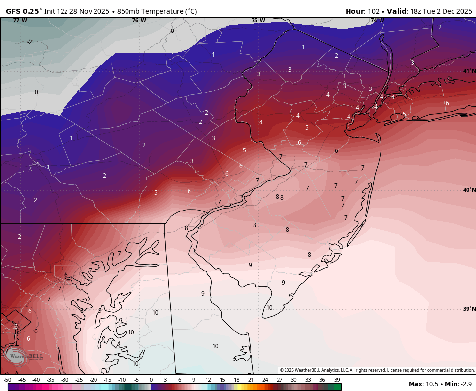
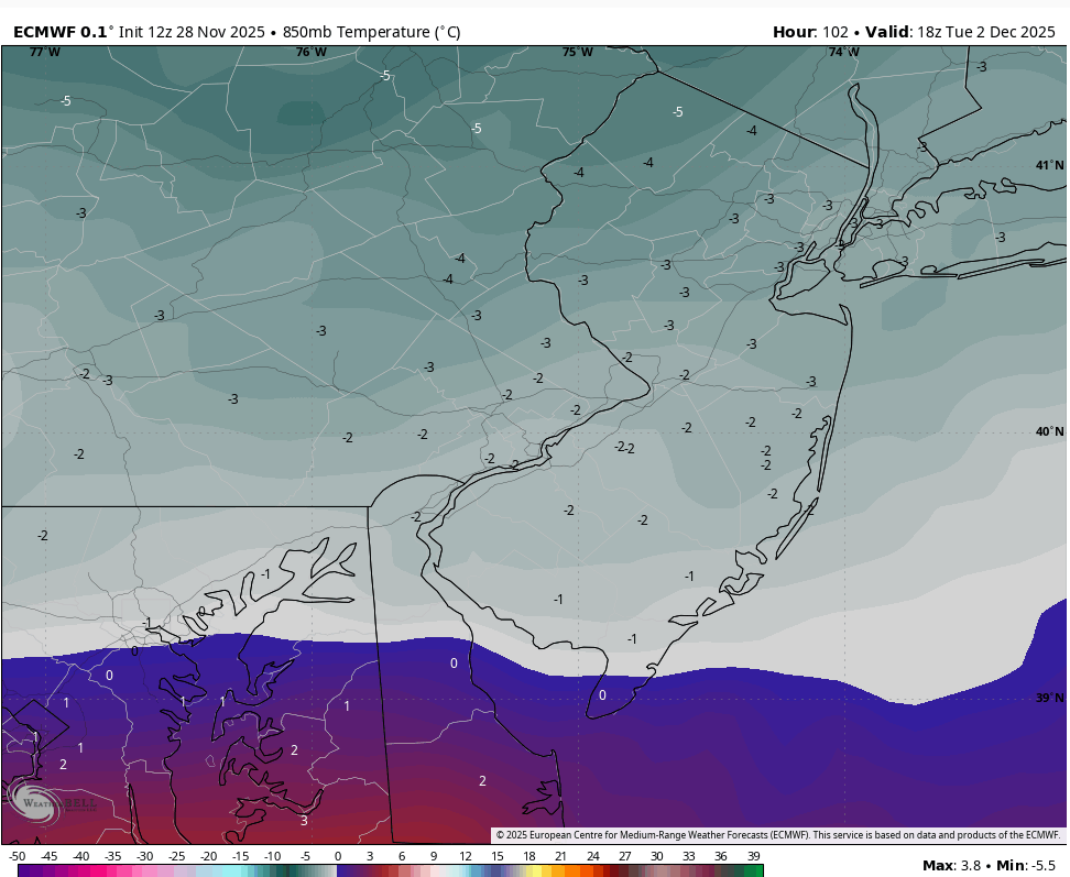
E PA/NJ/DE Autumn 2025 Obs/Discussion
ChescoWx replied to PhiEaglesfan712's topic in Philadelphia Region
A wee bit different take at the 850mb level between the GFS and European 12z....if GFS is right it rains up to MPO.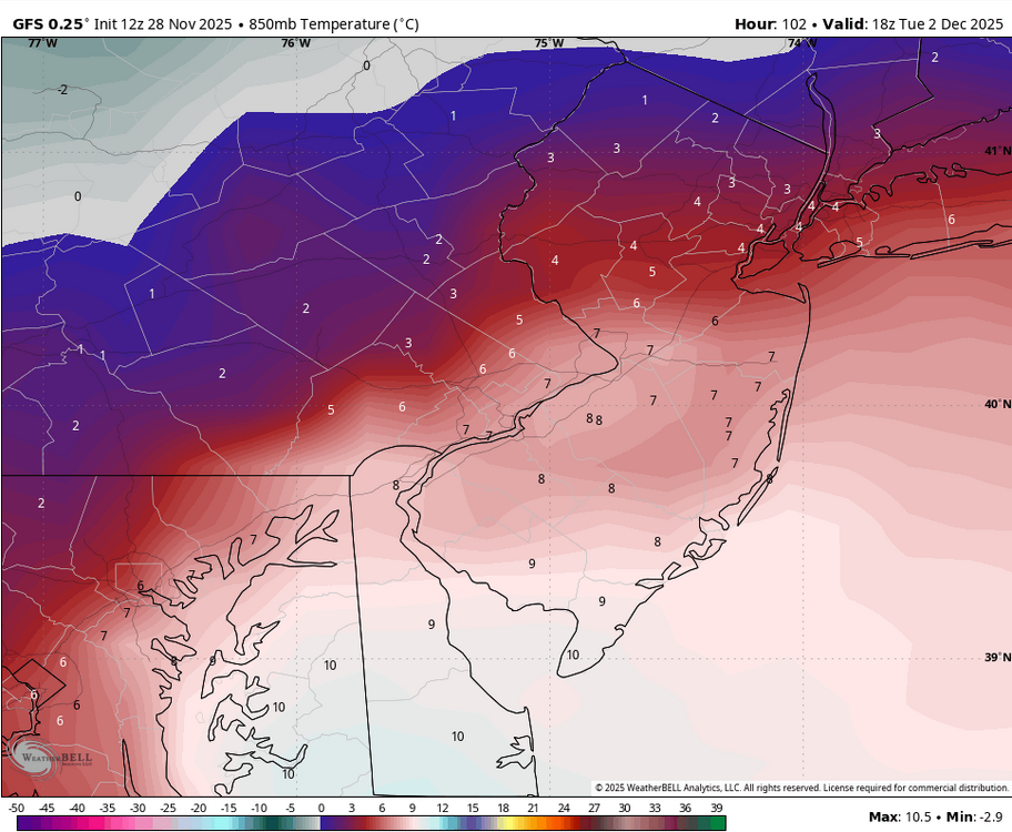

-
Ah, I see white stuff flying around here.
-
First Winter Storm to kickoff 2025-26 Winter season
Ginx snewx replied to Baroclinic Zone's topic in New England
Oh how you pray.. can't speculate on what later runs will show but solid dumping for many seems a lock. -
First Winter Storm to kickoff 2025-26 Winter season
Ginx snewx replied to Baroclinic Zone's topic in New England
Increased QPF and stronger inflow colder column what could go wrong Bretty -
Phase 8 December Haven't seen that in years
-

December 2025 Short/Medium Range Forecast Thread
Carvers Gap replied to John1122's topic in Tennessee Valley
Here are the d10-15 or d11-16 500 anomaly comparisons from the big four ensembles...Heights over Greenland are rising. BN heights over the SE. EPO/PNA ridge. BN heights over Alaska. It is correct that BN heights over Alaska don't teleconnect to BN heights over the SE as a general rule. But old school winters would have a cold Alaska and cold Southeast with an almost continuous cold feed from the Yukon into the Ohio Valley. It isn't without precedent, but recent climo is more or less against it. Interestingly, on the GEFS, the BN heights over Alaska are temporary and maybe on one other ensemble. Either way, that is a pretty decent cold signal for the first half of December. I won't rule out a big ridge rolling through for a few days. -
I urge all of you to look at climatology on webber weather to see how winters used to be. https://www.webberweather.com/nc-winter-weather-climatology.html
-

First Winter Storm to kickoff 2025-26 Winter season
dryslot replied to Baroclinic Zone's topic in New England
Yeah, There is some inland tracks on some of these members which leads me to believe that the Euro is probably going to come west some in the next few cycles. -

First Winter Storm to kickoff 2025-26 Winter season
dendrite replied to Baroclinic Zone's topic in New England
Skynet ens had more zonked members too -
December 2025 regional war/obs/disco thread
Ginx snewx replied to Torch Tiger's topic in New England
You slow... -
12z EPS has persistent cold for though the end.
-
12z Euro Ens has a favorable h5 look with hints of some energy taking the southern route. Prior to that it looks NS dominant but for this window maybe we can get a wave ejecting from the SW to slide underneath.
-
First Winter Storm to kickoff 2025-26 Winter season
dryslot replied to Baroclinic Zone's topic in New England
It looks to be moving towards the GFS so yeah An inside the BM track looks doable. -

-
Gee, I wonder where he got that from?
-
December 2025 regional war/obs/disco thread
Ginx snewx replied to Torch Tiger's topic in New England
Lol miss Matt. Aren't you Lars' son? -
You have to look at trends. Trends show the SE Ridge being muted but there enough to keep the storm track west.
-
December 2025 regional war/obs/disco thread
Ginx snewx replied to Torch Tiger's topic in New England
The more I see from his area 2015 wouldn't doubt if he did get 140 inches. grok_video_2025-11-28-14-18-25.mp4