All Activity
- Past hour
-
18z Gefs is a bit better on snowfall fwiw than 12z.
-
In the wake of the storm that brought rain to the region last night into early today, colder air will rush into the region tonight. The closing days of November will be much colder. There is potential for New York City's Central Park to experience its first freeze of 2025. The 1991-2020 normal first data is November 21. The 1961-1990 baseline was November 11. Last winter's first freeze occurred on November 30. The opening days of December will turn somewhat milder. However, colder conditions could begin to develop during the second half of that week and then continue into or through the second week of December. Severe cold appears unlikely through at least the first 10 days of December. The ENSO Region 1+2 anomaly was -0.7°C and the Region 3.4 anomaly was -0.7°C for the week centered around November 12. For the past six weeks, the ENSO Region 1+2 anomaly has averaged -0.16°C and the ENSO Region 3.4 anomaly has averaged -0.65°C. La Niña conditions will likely continue through at least mid-winter. The SOI was +20.23 today. The preliminary Arctic Oscillation (AO) was -0.232 today. Based on sensitivity analysis applied to the latest guidance, there is an implied 94% probability that New York City will have a cooler than normal November (1991-2020 normal). November will likely finish with a mean temperature near 46.9° (1.1° below normal). Supplemental Information: The projected mean would be 0.8° below the 1981-2010 normal monthly value.
-
Not here. Saw blue sky for 5 min
-
It's the 50th anniversary of "Jaws" this year...hey, that's gotta be worth something!
-
Pretty please that’s my birthday
-
Rather it show it over amped at this point than under amped. Hard to come back from lack of energy, easier to get it to de amplified
-
No rainbow here, but saw a pretty cool silverish/blue tint to the clouds leading into sunset. Got breezy as well.
-
current energy policy is bad for consumers, but good for fossil fuel folks
-
Heard thunder (last one of the year?) from that quick line. Chilly stretch coming up...hoping the Catoctin cloud magnet is on Tgiving break, so we can get some sunshine here during that span.
-
Fwiw gefs has stronger high this run vs last
-

Central PA Fall Discussions and Obs
WmsptWx replied to ChescoWx's topic in Upstate New York/Pennsylvania
Went to an appointment in Lewistown at 3:00. Sunny and 60. It was dark as shit and 56 at 3:30 when I left. -

Central PA Fall Discussions and Obs
Ruin replied to ChescoWx's topic in Upstate New York/Pennsylvania
I was looking forward to the mid 60s that were forecast today.Sad, they'd only ever got to 54 -

Central PA Fall Discussions and Obs
Voyager replied to ChescoWx's topic in Upstate New York/Pennsylvania
Keep them there...lol Side note. I thought I made a post about 1:30pm concerning the snow and my employment, but I don't see it. Maybe I forgot to hit reply? I don't know. Hope it wasn't deleted for some reason. -
12/6 2-4"+ on Gfs
-
Ain’t that awesome.
-
.gif.6331086e61d95a1157be171b74b66059.gif)
-
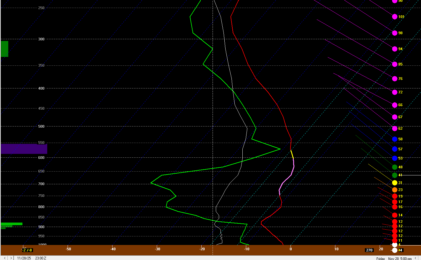
Nov 28-30th Post Turkey Day Wintry Potential
Paulie21 replied to Chicago Storm's topic in Lakes/Ohio Valley
Hope the GIF works.. 18z NAM for ORD here. Pretty decent co-location between Omega and DGZ. Fairly shallow DGZ sitting at 100-150mb depth; and though best omega is a bit above, still not too bad. There's also some slight jet coupling perhaps earlier in the event. Tough to tell the ratios between WAA snow, decent dynamics, but also at worst some precip mixing. Personally think KLOT is a bit lambish but it is tough to tell for now. We'll have a better idea with high res models of course. Hoping we can squeeze a brief weenie band somewhere midday in nIL.
-
Happy hour pbp is back!
-
More of a chance of rain than a whiff IMO
-
If you like cold/dry, warm/we…still probably dry, winter 25-26 is probably for you!
-
Great run for ski areas. Honestly, I’d be happy with it verbatim even though it’s more of a messy solution for my area.
-
Close but fringed.
-

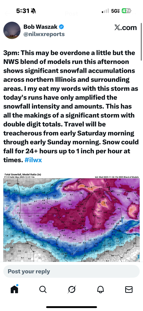
Nov 28-30th Post Turkey Day Wintry Potential
sbnwx85 replied to Chicago Storm's topic in Lakes/Ohio Valley
Just sharing because it shows the NWS Blend of models
-
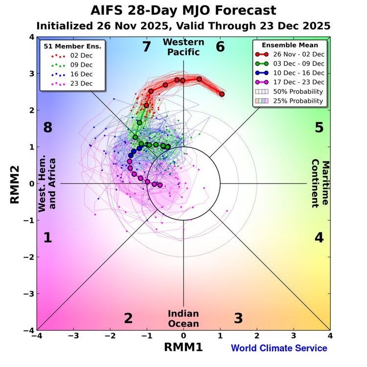
World Climate Service @WorldClimateSvc Quite excited about this: MJO forecast from the AIFS-ENS, including an in-house 28-day extension. Preliminary skill results are *very* interesting. Available soon to customers.
-

December 2025 regional war/obs/disco thread
TauntonBlizzard2013 replied to Torch Tiger's topic in New England
Looks great If youre dendrite