All Activity
- Past hour
-

Central PA Winter 25/26 Discussion and Obs
pasnownut replied to MAG5035's topic in Upstate New York/Pennsylvania
Not sure Im buyin what they are sellin, as this is a really wonky evolution, but as we are on the eastern side of the pig ridge in the central US, NAO is headed negative, and as i suggested last week, then models might be correcting once they latch on. Could be what we are seein here as the cold press starts to work its magic. I'll be casually looking as its a crazy busy time, but I hope we can pull somethin off, and keep the big warmup out west....out west. The zonalish look i suggested last week seems to be showing up as we turn the calendar. How long it lasts....we'll find out in a couple weeks. -

Possible Light Snowfall (1" - 4") on Tuesday Dec 23
donsutherland1 replied to Northof78's topic in New York City Metro
The WPC mapping tool isn't topographic. Hopefully, as AI allows for greater detail at reduced computing power, future maps will be topographic in nature to better capture elevation-related accumulations. -
(002).thumb.png.6e3d9d46bca5fe41aab7a74871dd8af8.png)
E PA/NJ/DE Winter 2025-26 Obs/Discussion
ChescoWx replied to LVblizzard's topic in Philadelphia Region
I suspect that high near 57 on Friday will be coming down significantly later today... -
I would say you are in a very good spot for something wintry. You have a decent chance at this one IMO.
-

Central PA Winter 25/26 Discussion and Obs
canderson replied to MAG5035's topic in Upstate New York/Pennsylvania
21 was my low -

December 2025 regional war/obs/disco thread
WinterWolf replied to Torch Tiger's topic in New England
I refused to even look at the texts…didn’t want to be influenced by the insanity…just came in here to see what went on overnight, and was pleased with the info. -
December 2025 regional war/obs/disco thread
WinterWolf replied to Torch Tiger's topic in New England
That’s pretty much it. Hopefully the kid could talk him down. -

E PA/NJ/DE Winter 2025-26 Obs/Discussion
PhiEaglesfan712 replied to LVblizzard's topic in Philadelphia Region
Just like I did on 3/29/2025, when in doubt, go the the NWS, which says too warm for snow: Christmas Day A chance of rain before 1pm. Cloudy, with a high near 44. Chance of precipitation is 30%. Thursday Night A chance of rain after 1am. Cloudy, with a low around 39. Chance of precipitation is 30%. Friday Rain likely. Cloudy, with a high near 57. Chance of precipitation is 70%. Friday Night A chance of rain before 1am. Mostly cloudy, with a low around 39. Chance of precipitation is 30%. Saturday Mostly cloudy, with a high near 51. Saturday Night A chance of rain. Mostly cloudy, with a low around 39. Chance of precipitation is 30%. Sunday A chance of rain. Mostly cloudy, with a high near 51. Chance of precipitation is 40%. -

Central PA Winter 25/26 Discussion and Obs
pawatch replied to MAG5035's topic in Upstate New York/Pennsylvania
14 degrees this morning. Just kind of a shame all this cold air will go to waste. -

December 2025 Short/Medium Range Forecast Thread
*Flash* replied to John1122's topic in Tennessee Valley
Merry Christmas to you! I agree 100% with this post; hence, why AmericanWx has become my 1a forum over the years. Understandably, for snow weenies at our latitude, we must contend with FOMO angst. Unless you're a FL/TX/CA transplant, warm holidays are hardly enjoyable, like a warm beer on a hot day. This riding 6 weeks of cold/dry and near misses to our north. 0.2" of snow IMBY since November 10. Drive 3 hours north and you get 500x. Say what you want about climo, but that's tough sleddin', pun intended. Like New Years resolutions, there's hope with a side of dopamine in anticipating a reset/workable pattern within 14-21 days. As long as we can get a quality two-week window during peak snow climo, I won't complain. Middle TN, in particular, has seen this work for several winters this century where DJF skews mild, but we somehow sneak to average snowfall or higher. Having just been discharged from the hospital with our last little Bag Fry, I've had time to reflect back to exactly 10 years ago when we were gearing down for our first. Unlike this month, December 2015 was pure torch with the pattern almost entirely ENSO dominant, but like this month, we were begging for a sign. The morale of the story has been alluded to in recent days with all the Grinch posters going to town. Even with the atmosphere, what goes up must come down. The question isn't 'if', but 'when'. Ask yourself, starting December 1...would you rather go cold/warm/cold or warm/cold/warm? We'll see how this all shakes out.
-
19.4, lotsa frost
-

December 2025 regional war/obs/disco thread
moneypitmike replied to Torch Tiger's topic in New England
And the Patriots last night. -
Pause the Mamma and Papa's - California Dreamin for about a week
-
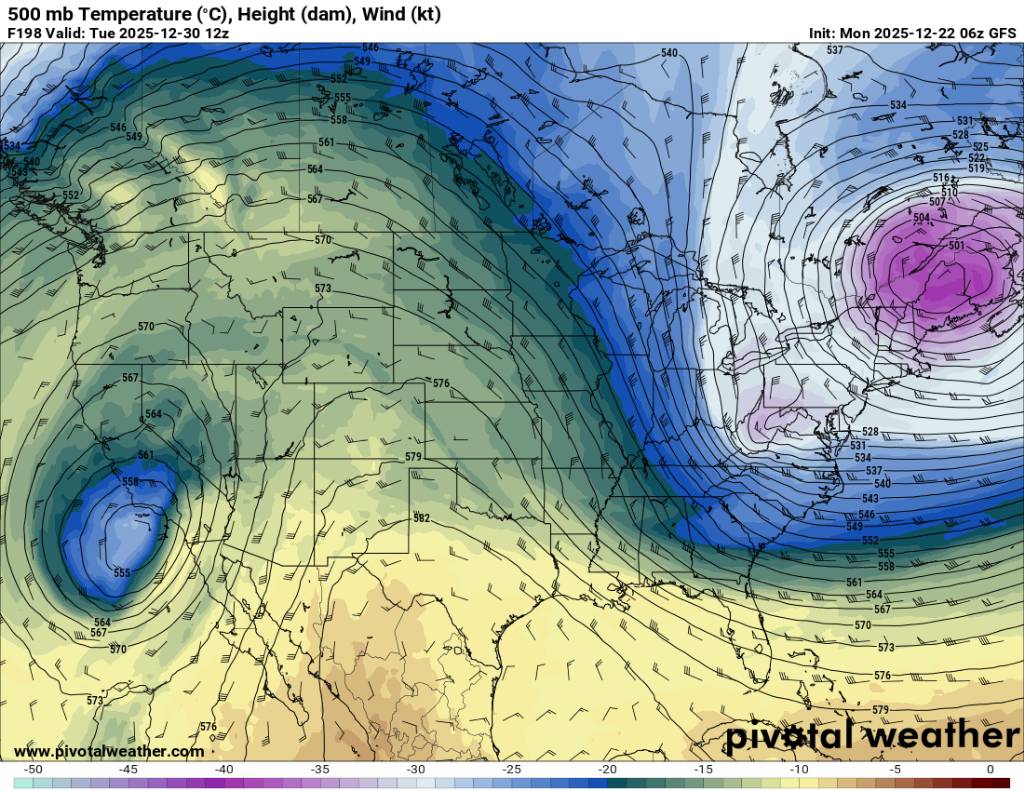
Welcome to the world of the super -NAO. Look at THAT trend.
-
Yeah he’s been on tilt…we’ll get him back if he can muster a decent event this week whether it’s Tuesday or Friday. As for the lack of posts on Friday mentioned by others…it’s kind of hard to speak intelligently on that threat since it’s been moving hundreds of miles within a couple cycles. It would be nice to see some stabilization on guidance.
-
If this trough verifies coming up that would mean non of the ensembles caught this outside day 7. Then the pattern again looks to be up and down. Sent from my SM-G998U using Tapatalk

.thumb.jpg.03c7278e0ca31ebf13722caf83d4fc1f.jpg)
.thumb.jpg.ac96754aa1c52667bd690f2f248b4665.jpg)
-
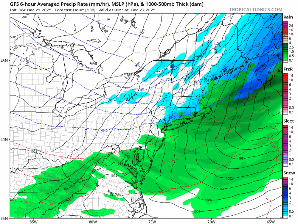
Dec Dep through the first 2/3 of the month (12/21) LGA: -6.7 NYC: -6.3 EWR: -5.9 JFK: -5.8 ISP: -3.4
-
What the hell is the GFS? I said maybe it could tick south last night, but wow. Uncancelling the cancellation of winter now?
-
Records: Highs: EWR: 71 (2013) NYC: 71 (2013) LGA: 69 (2013) JFK: 64 (2013) Lows: EWR: 7 (1989) NYC: 4 (1872) LGA: 8 (1989) JFK: 9 (1989) Historical: 1779: One of the "Hardest Winters" The winter of 1779-1780: This winter was so cold that ice was said to have been piled 20 feet high along the Virginia Coast and stayed there until spring. The upper portion of the Chesapeake Bay was frozen, allowing people to walk from Annapolis to Kent Island, Md. The Virginia portion of the Bay was frozen near the mouth, as well as all waterways in Virginia, which were firm enough to support the crossing of a regiment of the Virginia Infantry fighting the War of Independence as it marched from Falmouth to Fredericksburg, crossing the Rappahannock River, which had been frozen since the previous November. (Ref. Virginia Weather History) 1783: One of the "Long Winters" The winter of 1783-1784: Not as cold as 1780, this winter lasted longer into the spring, and was thought to rank near the top for extremes in cold and snow. The Chesapeake Bay once again froze almost all the way to the mouth. James Madison in Orange County, Va. wrote in a letter to Thomas Jefferson, " We had a severer season and particularly a greater quantity of snow than is remembered to have distinguished any preceding winter." The thaw caused an ice jam on the James River at Richmond that gave way, causing a flash flood of ice and water that swept away a bridge and sank boats that were tied up below the falls. Ice on the Potomac did not break until March 15th. (Ref. Virginia Weather History) 1839 - The second of triple December storms hit the northeastern U.S. The storm produced 25 inches of snow at Gettysburg, PA, and gales in New England, but only produced light snow along the coast. (David Ludlum) Dec. 22-23, 1839: Snow began around 3 a.m. in Washington, DC as a northeast gale intensified. The storm reached its greatest intensity around 9 p.m. that evening when the barometer dropped to its lowest point, 29.25 inches. Then the wind backed toward the northwest and snow continued until morning, with 10 inches accumulation in the city.(Ref. Virginia Weather History) 1908: The most snow to fall to date in Richmond since weather records were started in 1897 was 15.0 inches that fell just before Christmas in 1908. (Ref. Richmond weather recorded - KRIC) 1961 - Holiday travel was paralyzed over extreme northeastern Kansas, and adjacent parts of Missouri, Iowa and Nebraska. The storm produced 5 to 15 inches of snow, with drifts up to ten feet high. (22nd-23rd) (The Weather Channel) 1975: On December 20th through December 22nd 18.5 inches of snow fell over the Boston, Massachusetts area. This was their heaviest December snowstorm. Also on the 22nd Boston, Massachusetts had 14.0 inches of snow on the ground, greatest ever for December. (Ref. NOAA Boston Weather Events) 1983: On the first day of winter 75 cities reported record low temperatures for the date, with twelve of those cities reporting record low temperatures for the month as a whole. The mercury plunged to 51 degrees below zero at Wisdom MT, and Waco, TX set all-time records low a reading of 12 above zero.(The National Weather Summary) Wind chill readings were as low as -100 °F over a large part of North Dakota. Many locations from the West Coast to the Ohio Valley reported record low temperatures for the date including: West Yellowstone, MT: -43 °F, Williston, ND: -38 °F, Valentine, NE: -37 °F, Virginia City, MT: -35 °F, North Platte, NE: -34 °F, Casper, WY: -33 °F, Lander, WY: -31 °F, Bismarck, ND: -30 °F.(Ref. Wilson - Additional Temperatures Listed On This Link) 1983 - On the first day of winter 75 cities reported record low temperatures for the date, with twelve of those cities reporting record low temperatures for the month as a whole. The mercury plunged to 51 degrees below zero at Wisdom MT, and Waco TX set an all-time record low a reading of 12 above zero. (The National Weather Summary) 1987 - The first day of winter was a relatively tranquil one for much of the nation, but heralded a winter storm in the Central Rockies. The storm produced 40 inches of snow at the top of the Pomerelle Ski Resort, south of Burley ID, the heaviest snow of record for that location. (The National Weather Summary) (Storm Data) 1988 - Strong winds prevailed in the foothills of Wyoming and Colorado. Winds gusted to 123 mph southwest of Fort Collins CO, and reached 141 mph at the summit of Mount Evans. An ice storm paralyzed parts of Upper Michigan during the day. The freezing rain left roads around Marquette MI blocked by cars and semi- trucks. (The National Weather Summary) (Storm Data) 1989 - A total of 137 cities across the central and eastern U.S. reported record low temperatures for the date. Thirty-five of those cities established record lows for the month of December. Morning lows of 23 degrees below zero at Kansas City MO, 26 degrees below zero at Concordia KS, and 27 degrees below zero at Goodland KS established all-time records for those three locations. Unofficial morning lows included 50 degrees below zero at Recluse WY and 60 degrees below zero at Rochford SD. Broadus MT and Hardin MT tied for honors as the official cold spot in the nation with morning lows of 47 degrees below zero. Chinook winds at Cutbank MT helped warm the temperature 74 degrees, from a morning low of 34 degrees below zero to an afternoon high of 40 degrees. (The National Weather Summary) (Storm Data) 1989: The most significant cold spell of the century for the Deep South occurred from the 22 to the 26. New Orleans experienced 64 consecutive hours at or below 32 degrees Fahrenheit and a total of 81 out of 82 hours below freezing. A total of 15 hours was below 15 degrees with the lowest reading of 11 degrees on the morning of the 23rd. A low temperature of 8 degrees was recorded at Baton Rouge. Snow and sleet paralyzed transportation systems where as much as two to four inches of snow accumulated in Lafourche and Terrebonne Parishes. Snow and ice-covered the ground in New Orleans. The most significant impact was the breaking of water pipes in homes and businesses. Over 100 fires resulted in the New Orleans area within 24 hours due to a loss of water pressure and improperly utilized heating sources. Ice formed over shallow lakes and waterways where commercial fishing took heavy losses. Five weather-related deaths occurred in the service area during this rare Arctic outbreak. Between December 22 and December 24, 1989, deepening low pressure pulled a frigid arctic air mass into the southeastern United States. This sequence of events produced a historic snowstorm and a rare white Christmas across the region. At Charleston, South Carolina, the storm deposited 8 inches of snow – the greatest snowfall in modern history. At Savannah, Georgia, the storm total accumulation of 3.6 inches tied the greatest snowfall in modern history. 1990: ALL-TIME RECORD LOWS in Casper, WY -41 °F, Redding, CA +17 °F, Worland, WY -50 °F, Sacramento, CA +21 °F, and wind chills in ND. of -70 °F to -80 °F BELOW ZERO.(Storm Data) Wind chills in parts of North Dakota dropped as low as -80 °F. Locations reporting all-time record lows included: Worland, WY: -50 °F, Spring Valley State Park in Lincoln County, Nevada: -38 °F, Winnemucca, NV: -37 °F (broke previous daily record by 25 degrees), Denver, CO: -25 °F-Tied. Cheyenne, WY and Dodge City, KS equaled December record lows with -28 °F and -21 °F respectively. Locations reporting daily record lows included: Wisdom, MT: -52 °F, Lincoln Ranger Station, MT: -48 °F, Butte, MT: -44 °F, Chester, MT: -44 °F, Boulder, MT: -42 °F, Conrad, MT: -40 °F.(Ref. Wilson - Additional Temperatures Listed On This Link) 1993: Five inches of snow fell in just 20 minutes at Turin, NY. The town would be buried under 45 inches of snow during the lake effect snow event. Boonville, NY recorded 31 inches over a two day period. (Ref. Wilson Wx. History) 2001: Reagan National Airport in Washington, DC dropped to 29 degrees for a morning low for their first freezing temperature of the season. This set a new record for its latest first freezing temperature breaking the previous record of 12/14/1980. This also was the first time the location had not recorded a freezing temperature during the autumn season.(Ref. Wilson Wx. History) (Ref. Weather Guide Calendar with Phenomenal Weather Events 2011 Accord Pub. 2010, USA) 2004: Tremendous snows occurred in the Ohio Valley. The following cities set new records for their most significant snowstorm ever: Evansville, Indiana 22.3 inches, Dayton, Ohio 16.4 inches, and Paducah, Kentucky 14.2 inches. Other big snowfall totals were 31 inches at Liberty, Indiana, 28 inches at Buena Vista, Indiana, 24 inches at Greenville, Ohio, and 23 inches at Mansfield, Ohio. 2005: Southern Illinois: A fast moving snowstorm across the Midwest and Ohio Valley becomes the most significant snowstorm on record for southern sections of Illinois. Snowfall records are set at Carbondale (12 inches), McLeansboro (14 inches), and Carmi (18 inches).(Ref. WxDoctor) 2008: Wisconsin: Most of Wisconsin shivers as temperatures fell to below zero (-18 °C) with even colder wind-chill temperatures. The only parts of the state with above zero readings are in cities along Lake Michigan. The low temperatures hit -13 °F in Hayward and -12 °F in La Crosse. (Ref. WxDoctor)
-
If the gfs is correct we could be having snow and ice while Kansas City is pushing 80. Blocking does such cool stuff. I hope it's real!
-

December 2025 regional war/obs/disco thread
weatherwiz replied to Torch Tiger's topic in New England
Still great to see this upcoming period continuing to hold potential. The late weekend period has my eye -
27 / 14 sunny. Progressing to an overall near / below normal once passed the warmup Christmas (Eve/Day) 12/24 - 12/26. Friday into Sat slop / flop or snow to rain. Warmth to the south / west and cold pushing down into the northeast. Next storm threat, beyond Friday/Sat is for the 30/31. Beyond there - near normal.
-
Bottomed out at 20 here. .
-
GFS is so far south it’s a miss.
-
21 here much colder than I expected


.jpg.cca6ffac0c14129b7b0b7fd86096dc52.jpg)
.jpg.24a7fe90864ecd0ebda6c2950c6dece2.jpg)


