All Activity
- Past hour
-
A touch of frost on my roof earlier, but that was it. Low of 36 on my weather station. Otherwise, looks like a beautiful weekend for a change. Trey from KDKA did note a little wildfire smoke might make things a touch hazier tomorrow morning, but doesn’t look like it should be too thick by the time it reaches our latitude.
-
Yeah it looks like 2 days of sunshine and then showers with dry periods for the rest of the week. Was hoping for better but what can you do.
-
What a beautiful morning. I want to bottle it up for the next 4 months.
-

2025-2026 ENSO
Stormchaserchuck1 replied to 40/70 Benchmark's topic in Weather Forecasting and Discussion
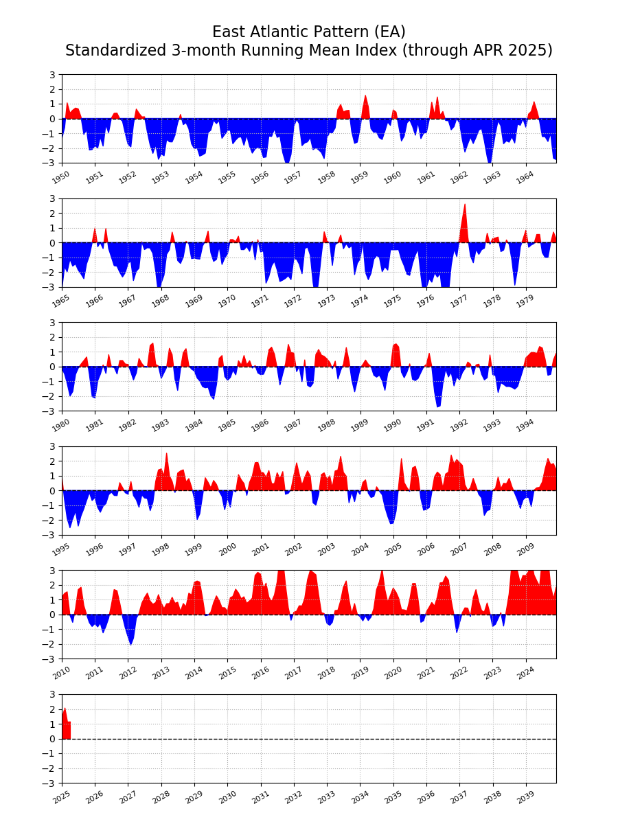
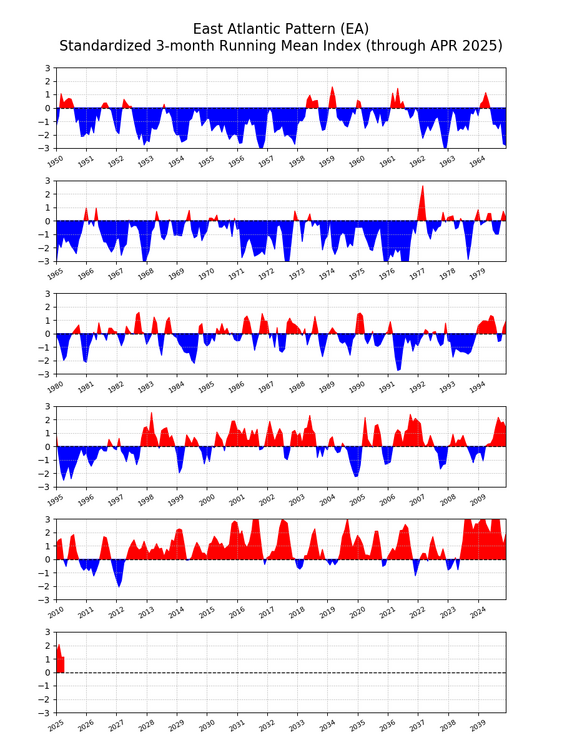
Good post bluewave. Europe has had a really linear Winter warming trend that has spanned the last few decades. I remember seeing a graph of Germany's snowfall and it was a consistent 25 degree angle down since the 1960s/70s. Last Winter Europe was really warm, so the trend continues there. It seems to be at least somewhat correlated to the NAO index, like you say. -
The one thing Elias got right in the offseason was signing Sugano. Dude throws 5 or 6 different pitches and has one of the filthiest splitters you will ever see.
-
AN for sure starting Monday. No 80s here for a while though. we take.
-
Few more hours and it’s back to summer . Warmish, increasingly dewy week on the way
-
Low was 36.8 (forecasted 38), but no frost here, wind stayed up JUST enough from the NW. The stuff in the garden still isn't thrilled with the temps lol. No where near record, which is 29.4 from 2022. Several more below 32's on this date, 1983, 2010, 2017 and 1980.
-
Yeah. Second part of the day looks salvageable.
-
Should be a nice sunny afternoon around here . May take until noon-1:00, but will shoot temps into 60’s then
-
Man this would have sucked immensely if this started today; would have been like the fourth Saturday/Sunday Rainer in a row.
-
Rain tapering off for now but probably pivots in later this morning. Blah. About 1.75”
-
did they cancel the Tag Sale?
-
At least Sunday and Monday will be sunny. After that, not so sure.
-
May rain (so far) thru May 9 NYC: 2.79 LGA: 2.16 JFK: 1.73 EWR: 1.18 New Brnswck: 1.02 TTN: 0.75 PHL: 0.37
-
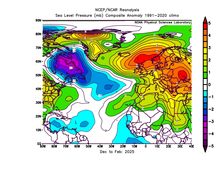
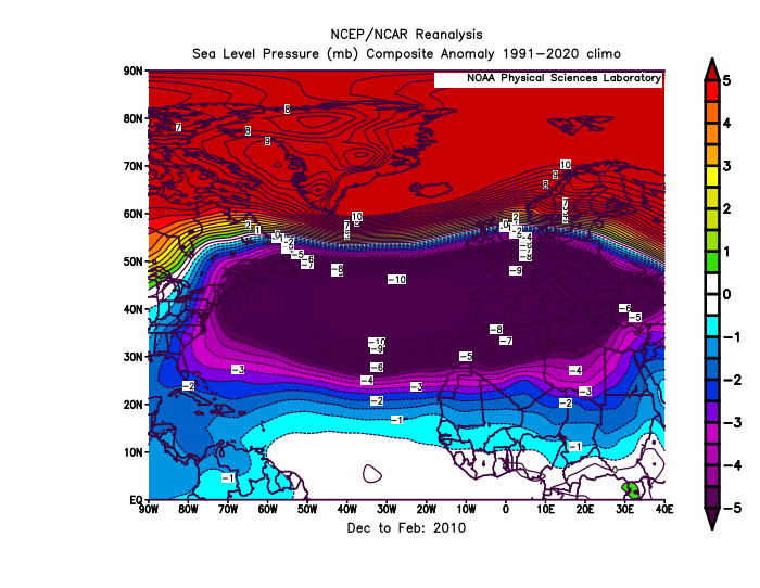
The NAO and AO have become really volatile over the years. With big swings from positive to negative over very short periods. So trying to do a detailed long range AO and and NAO forecast for next winter would probably be low skill at this point. This past winter the AO was negative and the NAO positive. This decoupling between the 2 indices has become more common during the 2020s. Plus on the days with .25 and more of precipitation around NYC this last winter the -AO and -NAO linked up with the Southeast Ridge. My guess is that this is related to surface pressures rising near the Azores during the winter. When the -AO links up with the Southeast Ridge the AO still registers as negative. But when the blocking near Iceland and Greenland links up with the East Atlantic or European Subtropical Ridge, the NAO registers as positive. So the rising pressures to the south near Europe have been preventing more -NAO winters in recent years. If we had lower pressures near the Azores this past winter, then it would have been a -NAO winter since pressures were above average near Iceland. Notice how much different it was from the pattern in 2010 with the record -NAO. The shift to a much more positive EA over time seems to have been also influencing the NAO. https://www.cpc.ncep.noaa.gov/data/teledoc/ea.shtml
-
A chilly 48 degree's at work this morning with a drizzle to welcome you into work.
-
36.7 this morning. A 4m model blend for Monday - Thursday rainfall is now 2.38". That would be heavenly!!!
- Today
-
I suspect that some of the rain totals are under reported due to debris in the tippers.
-
that should be my summer name
-
Records: Highs: EWR: 93 (1979) NYC: 94 (1979) LGA: 91 (1979) JFK: 90 (1979) Lows: EWR: 34 (1947) NYC: 36 (1966) LGA: 38 (1966) JFK: 34 (1966) Historical: 1905 - A deadly tornado hit the town of Snyder, OK, killing 87 persons. The tornado leveled 100 homes in Snyder, and destroyed many others. The large and violent tornado killed a total of 97 persons along its 40 miles path across southwestern Oklahoma. Its roar could reportedly be heard up to twelve miles away. (David Ludlum) (The Weather Channel) 1906 : LATEST SNOW ON RECORD at the Washington Weather Bureau Office It snowed for 33 minutes and the temperature reached 79 °F the next day. 1945: A rare late season coastal storm dumped 7 inches of snow on Portland, ME and 0.3 inches of snow fell at Fort Wayne, IN; their latest measurable snow. 1966 - Morning lows of 21 degrees at Bloomington-Normal and Aurora, IL, established a state record for the month of May. (The Weather Channel) 1987 - Summer-like "Father's Day" type weather prevailed in the north central and western U.S. for "Mother's Day", as seventeen cities reported record high temperatures for the date. Jamestown ND soared to a record high of 96 degrees. Thunderstorms along the Central Gulf Coast deluged Lillian AL with 14.5 inches of rain, and nearby Perdido Key FL with 12.8 inches of rain. (Storm Data) (The National Weather Summary) 1988 - Thunderstorms produced hail and high winds over the Atlantic Coast Region and the Gulf Coast States marking the end of a five day episode of severe weather associated with a cyclone tracking out of the Great Basin into southeastern Canada. (The National Weather Summary) 1989 - Thunderstorms developing ahead of a cold front crossing the Plateau Region produced wind gusts to 75 mph at Butte MT, and gusts to 77 mph at Choteau MT. (The National Weather Summary) (Storm Data) 1990 - A spring storm produced heavy snow in Upper Michigan and eastern Wiscosin. Totals ranged up to 12 inches at Marquette MI, with eight inches reported at Muskego WI and Hartford WI. The heavy wet snow, and winds gusting to 35 mph, damaged or destroyed thousands of trees, and downed numerous power lines. Total damage from the storm was more than four million dollars. (Storm Data) (The National Weather Summary)
-
While the records only go back to 1998, parts Orange County NY are already the 7th wettest May on record. Time Series Summary for MONTGOMERY ORANGE COUNTY AP, NY - Month of May Click column heading to sort ascending, click again to sort descending. 1 1998 6.80 0 2 2002 6.54 0 3 2011 5.39 0 4 2003 4.98 0 5 2024 4.94 0 6 2017 4.83 0 7 2025 4.77 23 8 2009 4.53 0 9 2021 4.50 0 10 2019 4.44 3
-
A little bit of thunder this morning.
-

OBS for OKX Flood Watch (attached) into early Saturday 5/10/25
IrishRob17 replied to wdrag's topic in New York City Metro
Where do you stand for May now? I'm guessing you're still ahead since I split the uprights for most of Thursday's showers, 4.68" here for the month. -
Ineedsnow to igotrain.


.thumb.png.4150b06c63a21f61052e47a612bf1818.png)