All Activity
- Past hour
-
Some good reasoning right here, Chris.... what are your thoughts on the increased NAO blocking in springtime, even late springtime (May).... is this a seesaw effect to balance out what we're seeing in the winter?
-
1.53" for the event
-
well it's been completely sunny here since sunrise.
-
If you're a customer of CON Edison, then you should know that they are predatory and have been prosecuted for spiking their prices. I'm a big believer in publicly controlled utility companies and price controls being in effect.
-
-
Mid 40s with light RA, only 0.3" in 12 hours thru 7 AM. Wood stove doing its thing.
-
Maybe you will get lucky start to dry out some. Good day to tip those AC units and drain some of the water.
-
A touch of frost on my roof earlier, but that was it. Low of 36 on my weather station. Otherwise, looks like a beautiful weekend for a change. Trey from KDKA did note a little wildfire smoke might make things a touch hazier tomorrow morning, but doesn’t look like it should be too thick by the time it reaches our latitude.
-
Yeah it looks like 2 days of sunshine and then showers with dry periods for the rest of the week. Was hoping for better but what can you do.
-
What a beautiful morning. I want to bottle it up for the next 4 months.
-

2025-2026 ENSO
Stormchaserchuck1 replied to 40/70 Benchmark's topic in Weather Forecasting and Discussion
Good post bluewave. Europe has had a really linear Winter warming trend that has spanned the last few decades. I remember seeing a graph of Germany's snowfall and it was a consistent 25 degree angle down since the 1960s/70s. Last Winter Europe was really warm, so the trend continues there. It seems to be at least somewhat correlated to the NAO index, like you say. -
The one thing Elias got right in the offseason was signing Sugano. Dude throws 5 or 6 different pitches and has one of the filthiest splitters you will ever see.
-
AN for sure starting Monday. No 80s here for a while though. we take.
-
Few more hours and it’s back to summer . Warmish, increasingly dewy week on the way
-
Low was 36.8 (forecasted 38), but no frost here, wind stayed up JUST enough from the NW. The stuff in the garden still isn't thrilled with the temps lol. No where near record, which is 29.4 from 2022. Several more below 32's on this date, 1983, 2010, 2017 and 1980.
-
Yeah. Second part of the day looks salvageable.
-
Should be a nice sunny afternoon around here . May take until noon-1:00, but will shoot temps into 60’s then
-
Man this would have sucked immensely if this started today; would have been like the fourth Saturday/Sunday Rainer in a row.
-
Rain tapering off for now but probably pivots in later this morning. Blah. About 1.75”
-
did they cancel the Tag Sale?
- Today
-
At least Sunday and Monday will be sunny. After that, not so sure.
-
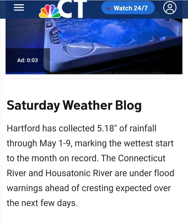
May rain (so far) thru May 9 NYC: 2.79 LGA: 2.16 JFK: 1.73 EWR: 1.18 New Brnswck: 1.02 TTN: 0.75 PHL: 0.37
-
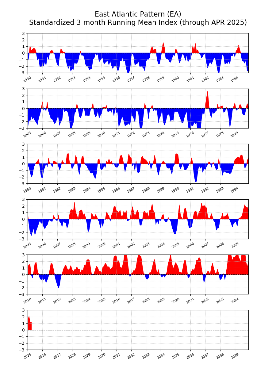
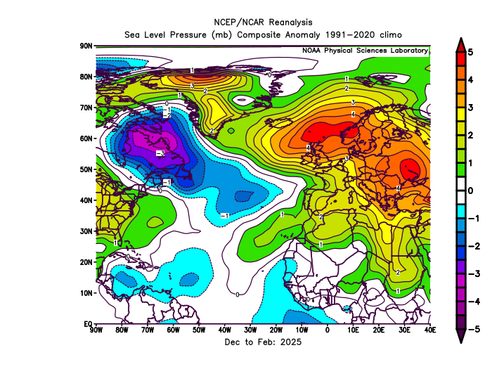
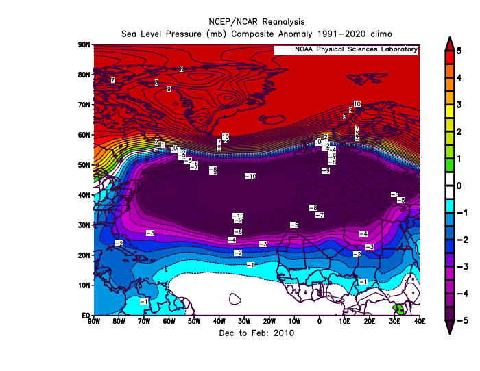
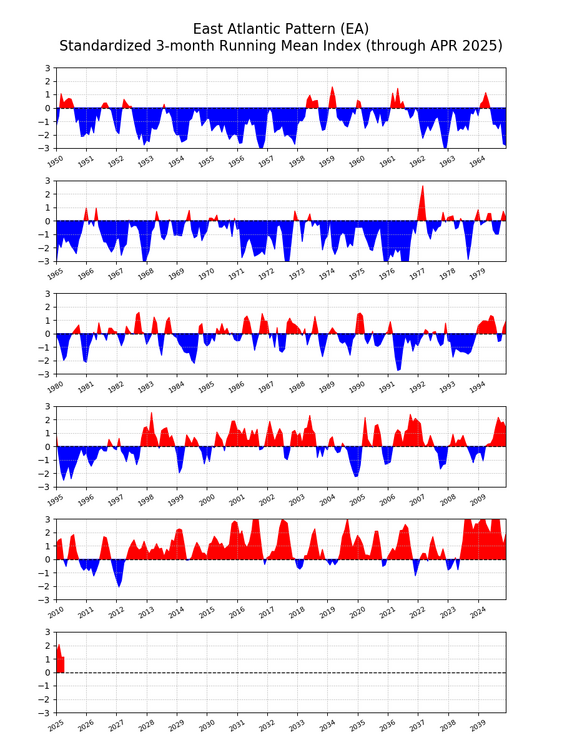
The NAO and AO have become really volatile over the years. With big swings from positive to negative over very short periods. So trying to do a detailed long range AO and and NAO forecast for next winter would probably be low skill at this point. This past winter the AO was negative and the NAO positive. This decoupling between the 2 indices has become more common during the 2020s. Plus on the days with .25 and more of precipitation around NYC this last winter the -AO and -NAO linked up with the Southeast Ridge. My guess is that this is related to surface pressures rising near the Azores during the winter. When the -AO links up with the Southeast Ridge the AO still registers as negative. But when the blocking near Iceland and Greenland links up with the East Atlantic or European Subtropical Ridge, the NAO registers as positive. So the rising pressures to the south near Europe have been preventing more -NAO winters in recent years. If we had lower pressures near the Azores this past winter, then it would have been a -NAO winter since pressures were above average near Iceland. Notice how much different it was from the pattern in 2010 with the record -NAO. The shift to a much more positive EA over time seems to have been also influencing the NAO. https://www.cpc.ncep.noaa.gov/data/teledoc/ea.shtml
-
A chilly 48 degree's at work this morning with a drizzle to welcome you into work.
-
36.7 this morning. A 4m model blend for Monday - Thursday rainfall is now 2.38". That would be heavenly!!!


.thumb.png.4150b06c63a21f61052e47a612bf1818.png)