All Activity
- Past hour
-
HRRRRRRRRRRRRNANDO
-
Too bad it ends at 48h. I wanted to see how long it rotted over the region.
-
Same here. Looks like a slight dry slought for the Cape with this track. Everybody else heavy

-
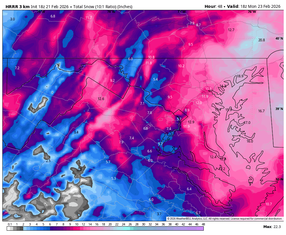
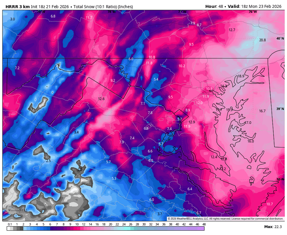
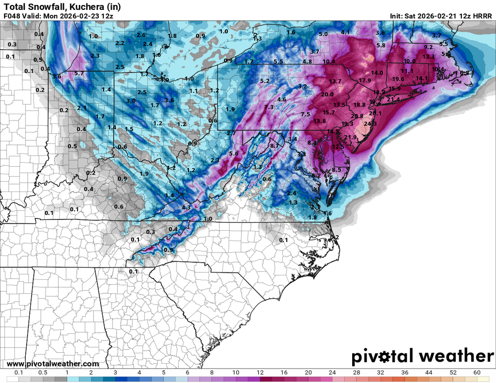
HRRR is 1 to 2 feet for everyone even well inland.
-
Incredible, over 24hrs and still dumping.
-

“Cory’s in NYC! Let’s HECS!” Feb. 22-24 Disco
Baroclinic Zone replied to TheSnowman's topic in New England
Damn… 2.25” for me and still going. -
What are the Mets (and others) in on here thinking about the general onset time for I-495 corridor from Haverhill area to the Cape?
-
Some places went from nothing straight to warning from LWX
-
Thats 12z
-
Don't feel bad I'm supposed to drive from Magnolia Delaware to Ft Meade MD @ 2:30 a.m. Monday and just called out.
-

“Cory’s in NYC! Let’s HECS!” Feb. 22-24 Disco
Diggiebot replied to TheSnowman's topic in New England
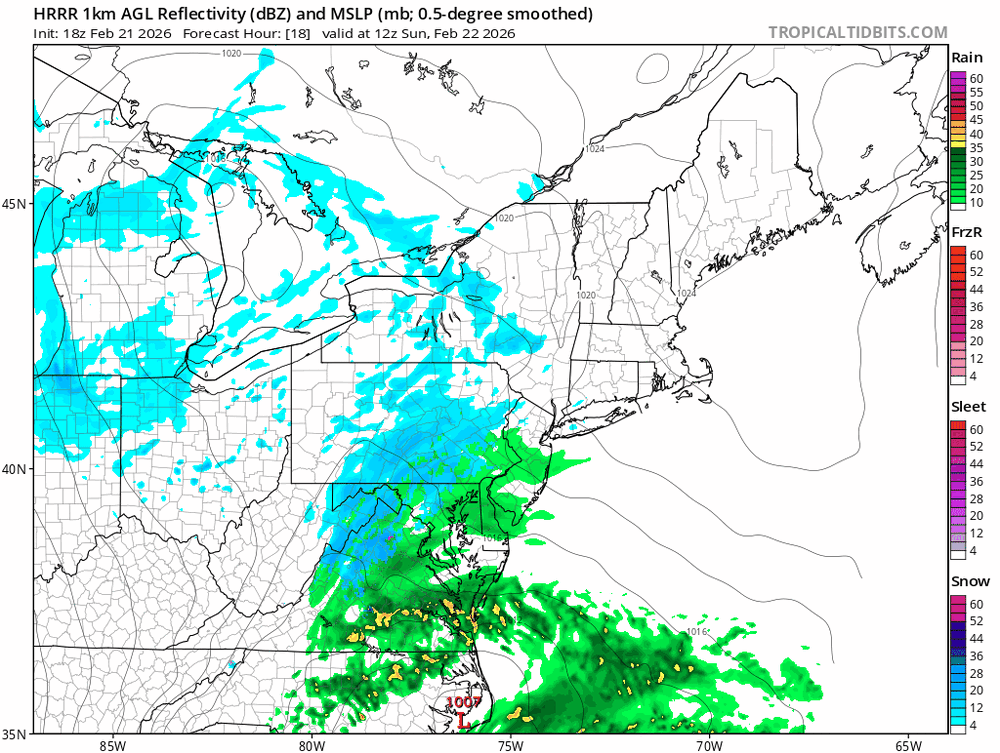
White hurricane vibes on that sim radar -
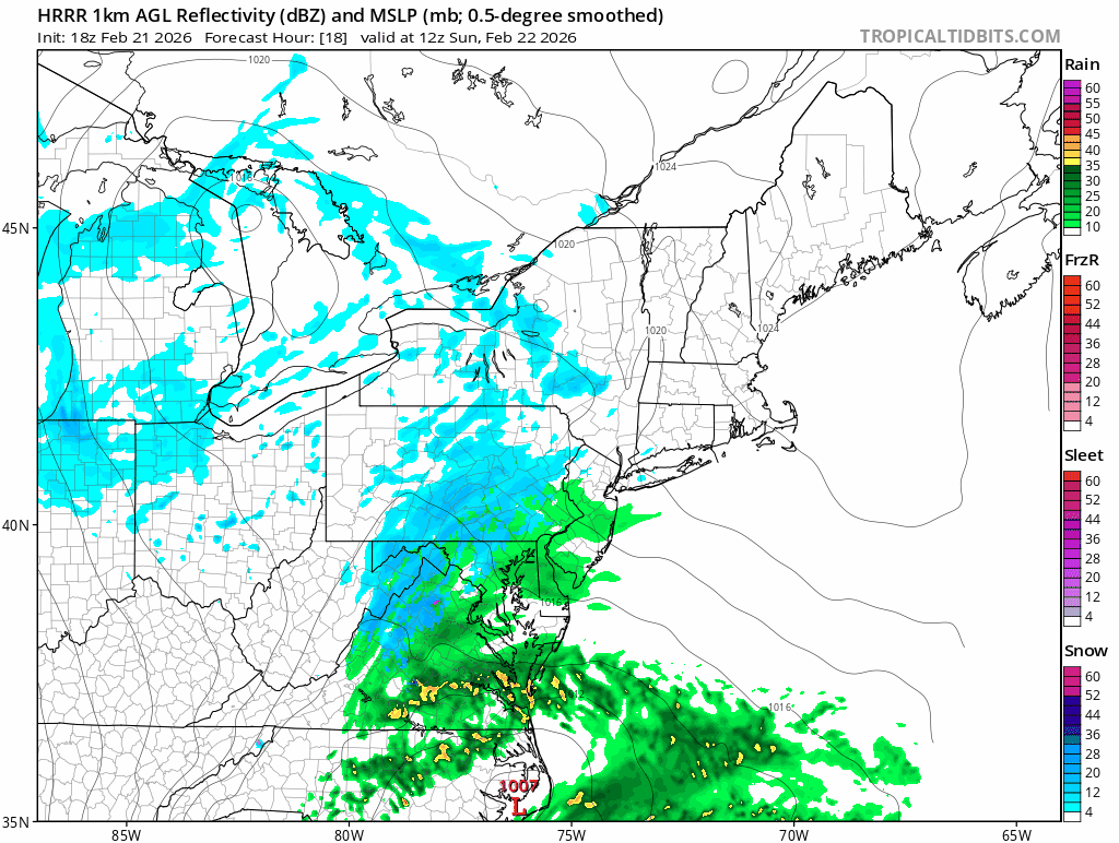
Wobbles north during an ERC
-
Always appreciate professionals like you taking time on here! thanks!!
-
@MillvilleWx the HRRR and NAM 3k have been consistent on a McLean/Tysons/Vienna local jack. Is this due to elevation? (12” vs 5” at DCA 10:1)
-

Central PA Winter 25/26 Discussion and Obs
Mount Joy Snowman replied to MAG5035's topic in Upstate New York/Pennsylvania
HRRR could make a grown man cry, snows through lunchtime on Monday. -

E PA/NJ/DE Winter 2025-26 Obs/Discussion
PhiEaglesfan712 replied to LVblizzard's topic in Philadelphia Region
Is this still slush or now mud? -
Makes sense, can always upgrade. I like when LWX plays catch up anyways.
-

“Cory’s in NYC! Let’s HECS!” Feb. 22-24 Disco
ineedsnow replied to TheSnowman's topic in New England
low moves back NW a bit at hr45 -
URGENT - WINTER WEATHER MESSAGE National Weather Service Wakefield VA 242 PM EST Sat Feb 21 2026 MDZ021>025-220345- /O.UPG.KAKQ.WS.A.0003.260222T1500Z-260224T0000Z/ /O.NEW.KAKQ.BZ.W.0001.260222T1800Z-260224T0000Z/ Dorchester-Wicomico-Somerset-Inland Worcester-Maryland Beaches- 242 PM EST Sat Feb 21 2026 ...BLIZZARD WARNING IN EFFECT FROM 1 PM SUNDAY TO 7 PM EST MONDAY... * WHAT...Blizzard conditions expected. Total snow accumulations between 8 and 14 inches. Winds gusting as high as 45 to 50 mph. * WHERE...Dorchester, Inland Worcester, Maryland Beaches, Somerset, and Wicomico Counties. * WHEN...From 1 PM Sunday to 7 PM EST Monday. * IMPACTS...Travel could be very difficult to impossible. The hazardous conditions could impact the Monday morning and evening commutes. Gusty winds could bring down tree branches.
-
URGENT - WINTER WEATHER MESSAGE National Weather Service Baltimore MD/Washington DC 246 PM EST Sat Feb 21 2026 MDZ004-503-VAZ505-506-220400- /O.UPG.KLWX.WS.A.0003.260222T2000Z-260223T1500Z/ /O.NEW.KLWX.WS.W.0003.260222T2000Z-260223T1500Z/ Frederick MD-Northwest Montgomery-Western Loudoun-Eastern Loudoun- 246 PM EST Sat Feb 21 2026 ...WINTER STORM WARNING IN EFFECT FROM 3 PM SUNDAY TO 10 AM EST MONDAY... * WHAT...Heavy snow expected. Total snow accumulations between 3 and 6 inches. For elevations above 1,000ft, snow accumulations upwards of 6 to 12 inches are expected. Winds gusting as high as 35 mph. * WHERE...In Maryland, Northwest Montgomery and Frederick MD Counties. In Virginia, Eastern Loudoun and Western Loudoun Counties. * WHEN...From 3 PM Sunday to 10 AM EST Monday. * IMPACTS...Roads, and especially bridges and overpasses, will likely become slick and hazardous. Plan on slippery road conditions. The hazardous conditions could impact the Monday morning commute. PRECAUTIONARY/PREPAREDNESS ACTIONS... If you must travel, keep an extra flashlight, food, and water in your vehicle in case of an emergency. The latest road conditions for the state you are calling from can be obtained by calling 5 1 1.
-
-

“Cory’s in NYC! Let’s HECS!” Feb. 22-24 Disco
Damage In Tolland replied to TheSnowman's topic in New England
Look at the deep Easterly inflow . Things you love to see -
WWA hoisted for DC and immediate burbs:
-
Map?
-

Central PA Winter 25/26 Discussion and Obs
Voyager replied to MAG5035's topic in Upstate New York/Pennsylvania
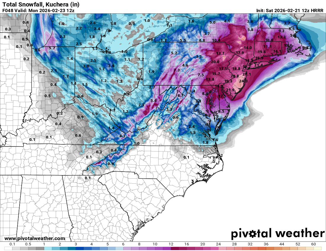
Gotta love the range from low end to expected to high end for Tamaqua...


(002).thumb.png.6e3d9d46bca5fe41aab7a74871dd8af8.png)