All Activity
- Past hour
-

The “I bring the mojo” Jan 30-Feb 1 potential winter storm
Buddy1987 replied to lilj4425's topic in Southeastern States
GFS looking very similar thus far at hr 48. Key is somewhere between hr 84-90 to see the trough axis and pivot point in my mind. -

Possible coastal storm centered on Feb 1 2026.
HoarfrostHubb replied to Typhoon Tip's topic in New England
Too many models -

Texas 2026 Discussion/Observations
Snowstorms replied to Stx_Thunder's topic in Central/Western States
Impressive sleet/snow pack. The layer of ice ontop certainly doesn't help. Hoping it will melt more rapidly tomorrow but the nights look to remain below freezing all week with forecasted lows around 20 tonight. -
Interesting where the WPC has the storm. Kinda close to coast. They must be riding the GFS.. unless they see something we dont
-
Yeah still looks just about the same as 12z and better than the other 12z models
-

The “I bring the mojo” Jan 30-Feb 1 potential winter storm
DTP replied to lilj4425's topic in Southeastern States
Ha- remember this storm well- still one of my all-time favorites..... lived off of Harris Blvd/Davis Lake in N CLT at the time....remember waking up to 8"+ of blowing snow and a 15 degree air temp- don't see that very often down in the S Piedmont -
Peaked at 29 for the warmest day of the week
-
Hour 36, ridging looks slightly higher, but I never do pbp, so I'm going to sit back and watch
-
Important panel will be hour 84, 6z sat... We want the pivot point for the energy at 500 to be in southern Michigan/Northern Indiana
-

Pittsburgh/Western PA WINTER ‘25/‘26
colonel717 replied to Burghblizz's topic in Upstate New York/Pennsylvania
Latest 18z Icon EPS, there are 5 pretty east members. 2 are in eastern PA for weekend -
By NWS forecast has now introduced “heavy snow” for Saturday.
-
I went back to read the fish storm bomb thread on page 21 and you could cut and paste a lot of these posts from today.
-
Early returns (h30) say a hold
-
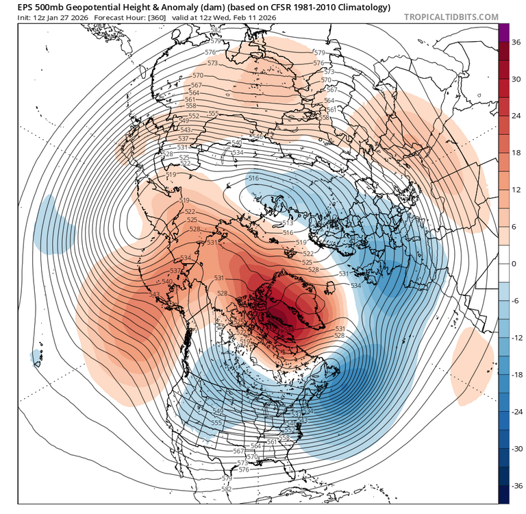
If i recall, that happened in 2011-12 and 2012-13 to some degree. How many -NAO Nina Marches have we've experienced and what was the resulting 500mb pattern?
-

Possible coastal storm centered on Feb 1 2026.
CoastalWx replied to Typhoon Tip's topic in New England
Igone -

The “I bring the mojo” Jan 30-Feb 1 potential winter storm
BooneWX replied to lilj4425's topic in Southeastern States
Lil bit of a gulf tap to it. I’ve seen some hints (faint) on the ensembles for that and it’s not out of the question. That would certainly be a game changer. You’d get almost a board wide event. -

Possible coastal storm centered on Feb 1 2026.
EastonSN+ replied to Typhoon Tip's topic in New England
Lol yeah when I saw the response I went to the MA forum to check and thats a good cluster off of the DelMarva. -
Neither does any model. This is one of the least predictable setups you could possibly have in an east coast winter storm.
-
Baltimore City is closed tomorrow, their last snow day of the year, all other days would be virtual instruction
-
High of 27. Currently 25.
-
Sadly, I have no faith that the GFS is correct.
-
I am here for every laugh that will generate. Even though we know its not happening, I'd pay to see it.
-
Pittsburgh/Western PA WINTER ‘25/‘26
colonel717 replied to Burghblizz's topic in Upstate New York/Pennsylvania
I looked for some discussion of it. But nothing. You can see snow breaking out over central Ohio, so snow may develop along that front. Also now breaking out in front of the front. I am actually driving up to Grove City later tonight. -
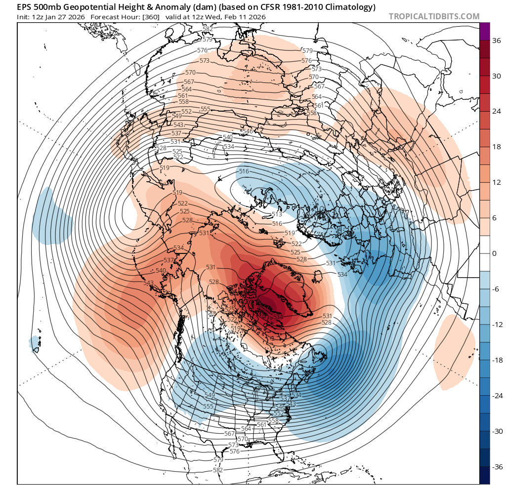
Hey Don, you had mentioned that we do better with an RNA in February. Latest EPS has this with blocking.
-
 It's kinda of amazing driving around today. This felt like it had the impact of a 2 foot storm due to the sleet and density of the snowpack. Combined with the lack of melting and cold temperatures