All Activity
- Past hour
-
700mb reaches close t0 +4 near DCA at 81 fwiw
-

January 24-26: Miracle or Mirage JV/Banter Thread!
Interstate replied to SnowenOutThere's topic in Mid Atlantic
spoke too soon... did save 3 hours of snow though -
It is NAM with 2.5 days before onset…
-
I think we get less than an inch of precip here.
-

Winter 2025-26 Medium/Long Range Discussion
OrdIowPitMsp replied to michsnowfreak's topic in Lakes/Ohio Valley
Was out in Colorado 1/8-1/15, got blessed with 10” of powder on day 1, but it’s historically bad out there. Definitely the worst season on record. People throw out 76/77 but they didn’t have snowmaking to supplement things back then. Fire season will be lit. (Pun intended) -

Pittsburgh/Western PA WINTER ‘25/‘26
TimB replied to Burghblizz's topic in Upstate New York/Pennsylvania
Sleet is up to about Bethel Park at 81, then we dry slot. -

Possible Record Breaking Cold + Snow Sunday 1/25 - Tuesday 1/27
weatherpruf replied to TriPol's topic in New York City Metro
All lousy events out here so I hope Not . -
For it being the Nam it’s not bad lol. 5” on the Nam may as well be 10” on the legit models
-

January 25/26 Jimbo Back Surgery Storm
Blacksburg Coach replied to Jimbo!'s topic in Southeastern States
Not sure how to fix it, more education I guess. Getting people to understand the difference between possible and probable. -

Pittsburgh/Western PA WINTER ‘25/‘26
colonel717 replied to Burghblizz's topic in Upstate New York/Pennsylvania
-

January 24-26: Miracle or Mirage Thread 2
NorthArlington101 replied to mappy's topic in Mid Atlantic
Warm layers can 100% race north quickly, though I'm still not gonna worry about NAM ptype until tomorrow at 06z at earliest -
Don't trust the NAM precip fields out that far.
-
The short range says this isnt a catastrophic ice storm. Keep trending west and we dry slot
-

Pittsburgh/Western PA WINTER ‘25/‘26
MikeB_01 replied to Burghblizz's topic in Upstate New York/Pennsylvania
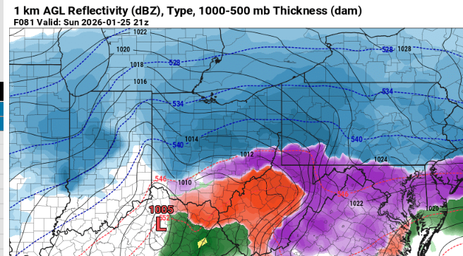
I think it look very similar to the 6z. Only difference i can see through hr 69 is the HP over new england is suprressing the precip shild slightly. At the 500 level, the southern energy seems to be a little more outfront of the kicker from the north. This should cause more amplification, but it doesn't appear to be when you look at the reflectivity maps -
January 24-26: Miracle or Mirage JV/Banter Thread!
Interstate replied to SnowenOutThere's topic in Mid Atlantic
How that little shift south on the NAM saved my ass from sleet by 10 miles... -

Possible Record Breaking Cold + Snow Sunday 1/25 - Tuesday 1/27
Snowlover11 replied to TriPol's topic in New York City Metro
It wouldn’t be a legit winter storm if we didn’t have a NAMing. -

Pittsburgh/Western PA WINTER ‘25/‘26
Burghblizz replied to Burghblizz's topic in Upstate New York/Pennsylvania
It was looking stringy and unorganized at first, but it’s getting its act together by hour 72. The end result will be good. -
NAM was better but still the low end totals as it almost misses the thump for places south of NOVA. I for example get 3 inches of snow which would be... not great
-
Nam being the Nam my guess that light zone is actually snow. You don’t have a light precip zone in middle of the heavies
-

2025-2026 New England Snow Recordkeeping Thread
subdude replied to bristolri_wx's topic in New England
Wow, ya still in Gardner. I guess I did miss a few of these nuisance snows. lol. They do add up. Tack on another 1.5" today. Overall it's been a decent winter here in N. ORH county. -

Winter cancelled/uncancelled banter 25/26
TheClimateChanger replied to Rjay's topic in New York City Metro
In all, there are 307 days on which the current record high is unmatched, 59 days in which the record high was set in at least 2 years, 11 days in which the record high was set in at least 3 years, and 2 days in which the record high was set in 4 years. -

Possible Record Breaking Cold + Snow Sunday 1/25 - Tuesday 1/27
Nibor replied to TriPol's topic in New York City Metro
-

January 24-26: Miracle or Mirage JV/Banter Thread!
nw baltimore wx replied to SnowenOutThere's topic in Mid Atlantic
Where's the "wtf?" reaction? -
Still plows that primary into the ov and slower to redevelop off coast this run. Alot of balancing out of features that yield a very similar result at the surface. Alas, its the nam at range.
-
Nam looks more consolidated at 500 through hr 72. That’s gonna be a thump as modeled.


