All Activity
- Past hour
-

2026-2027 Super El Nino
mitchnick replied to Stormchaserchuck1's topic in Weather Forecasting and Discussion
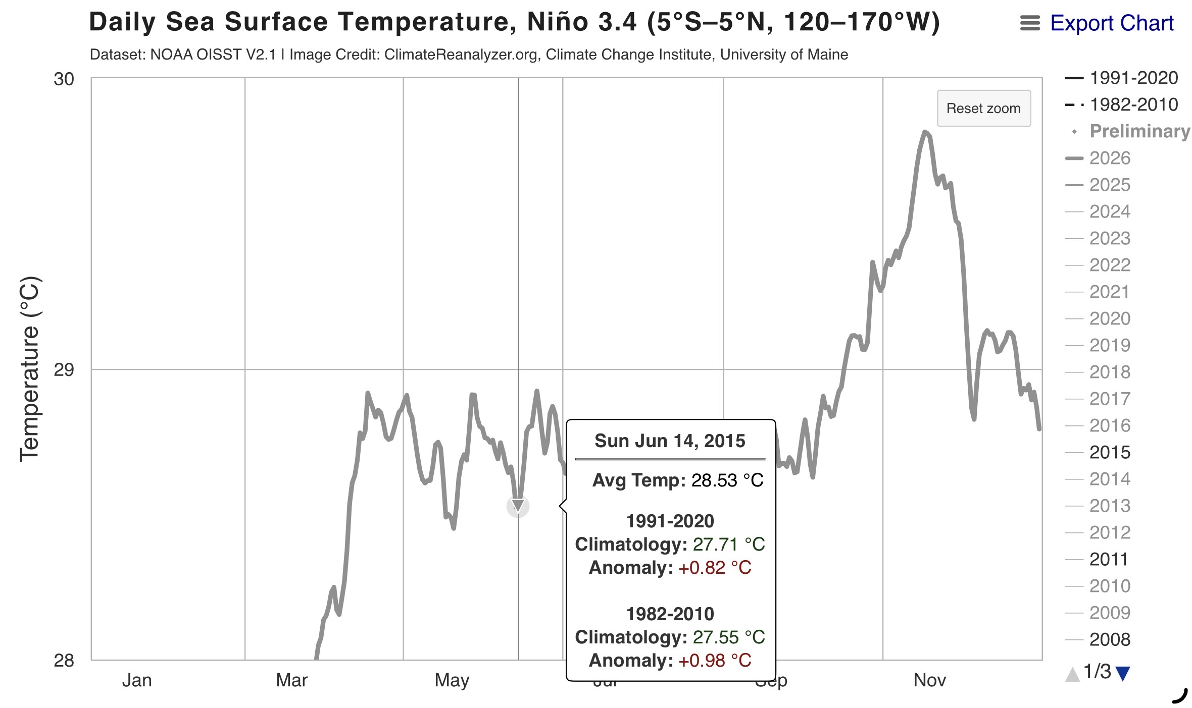
Here are CPC numbers for all 4 Enso areas for 6/10/15 & 6/10/26: 10JUN2015 25.5 2.0 27.8 1.2 28.7 0.9 29.8 0.9 10JUN2026 26.1 2.7 28.3 1.6 29.2 1.5 30.1 1.3ⁿ If you divide Enso 1.2 anomaly into the other 3 areas' anomalies for both years, you get respectively 60%, 45% and 45% in 2015 and 59.25%, 55.55% and 48.15% this year. Comparing the 2 years, Enso 3 is nearly identical for both years and 3.4 and 4 are a hair warmer this year than 2015. Obviously, there may be other ways to figure it, but I'd have to say that they are very similar with a slight edge to 2015 as being more east based under this method. -

Pittsburgh PA Summer 2026 Thread
TheClimateChanger replied to TheClimateChanger's topic in Upstate New York/Pennsylvania
-

E PA/NJ/DE Summer 2026 Obs/Discussion
Birds~69 replied to PhiEaglesfan712's topic in Philadelphia Region
-
Kind of wondering if this setup is going to over-convect. Several models are showing a line of supercells. May be too much storm competition for a widespread tornado setup. Gonna be interesting to see how this plays out.
-
I drove home from NJ at 10:00 PM last night and it was some of the hardest rain i have ever seen. At points i had to pull over because i couldn't see a thing out of my windshield. It was crazy.
-
Forecast: mostly sunny. Reality so far: mostly cloudy. Temps are great, tho. Went to Schaeffer Farms yesterday and pushed thru a long trail ride. Fun trails and was generally dry, but man there is some thorny overgrowth in multiple sections and I brought a tiny tick home with me near my shin. Guys, check yourselves after hiking/mtb…those things are out and about. Surprised I even noticed it.
-

E PA/NJ/DE Summer 2026 Obs/Discussion
JTA66 replied to PhiEaglesfan712's topic in Philadelphia Region
We start losing daylight next week. NFL training camps open next month. -
Had a couple good downpours late yesterday. Idk what’s going on, but mby has done well with precip the last couple months.
-
I want to believee
-
I love those maps, its been a while. I'm surprised in OH valley the rec low slps are that high, and the gradient between central ON and central MI.
-
Main action likely to miss east and especially south of here. Should get a nice non severe MCS in the morning though.
-

2026-2027 Super El Nino
snowman19 replied to Stormchaserchuck1's topic in Weather Forecasting and Discussion
There’s also a big divergence with 2015…this one is way more east-based than 2015 was -

Junorch obs and discussion 2026
Damage In Tolland replied to Damage In Tolland's topic in New England
Steined is the way of the walk . -
dry and semi warm this summer?
-
I’m feeling outshined
-

2026-2027 Super El Nino
roardog replied to Stormchaserchuck1's topic in Weather Forecasting and Discussion
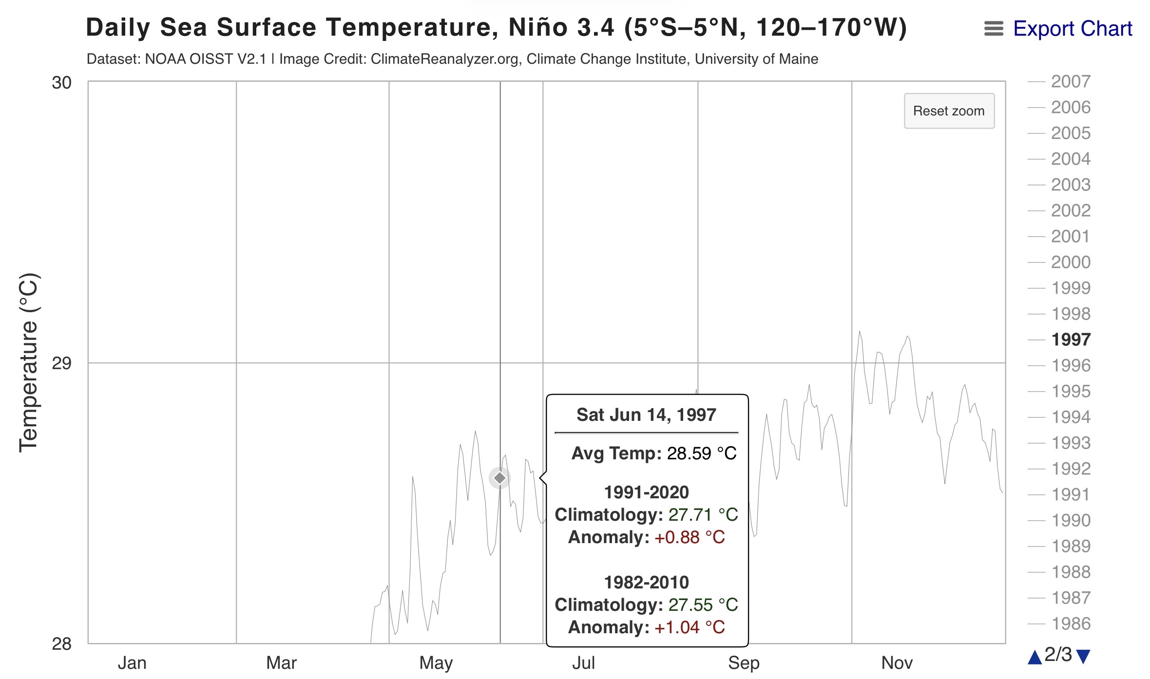
Now that we’re heading through June we can see the big divergence with 1997 is going to be Nino 4. This shouldn’t really be a surprise to anyone but it’s still a big deal IMO. -

2026-2027 Super El Nino
bluewave replied to Stormchaserchuck1's topic in Weather Forecasting and Discussion
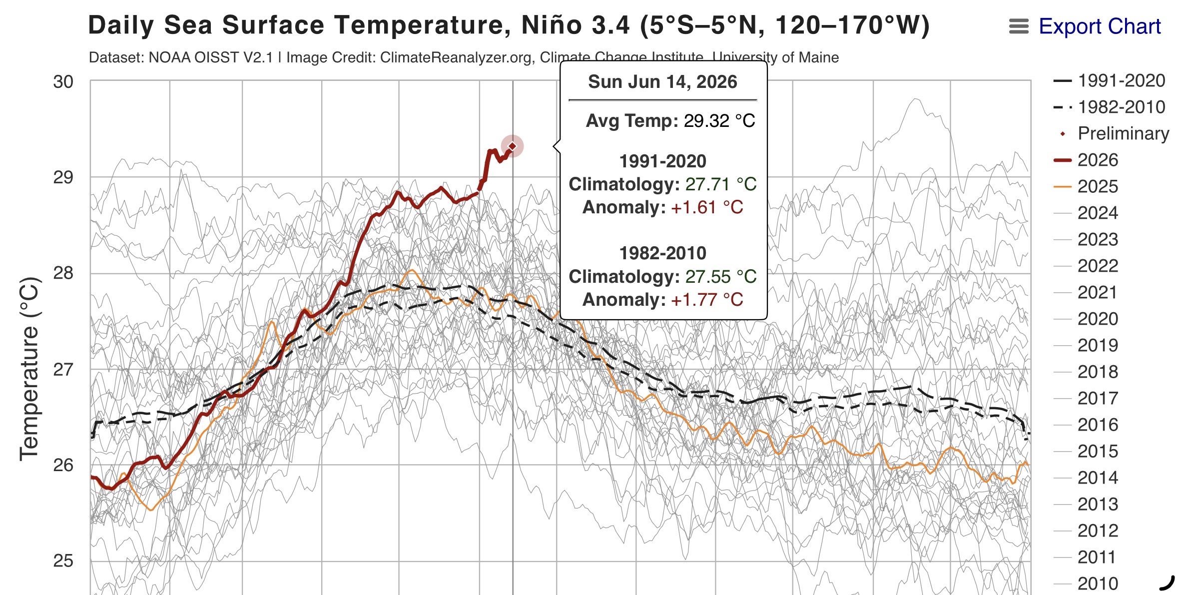
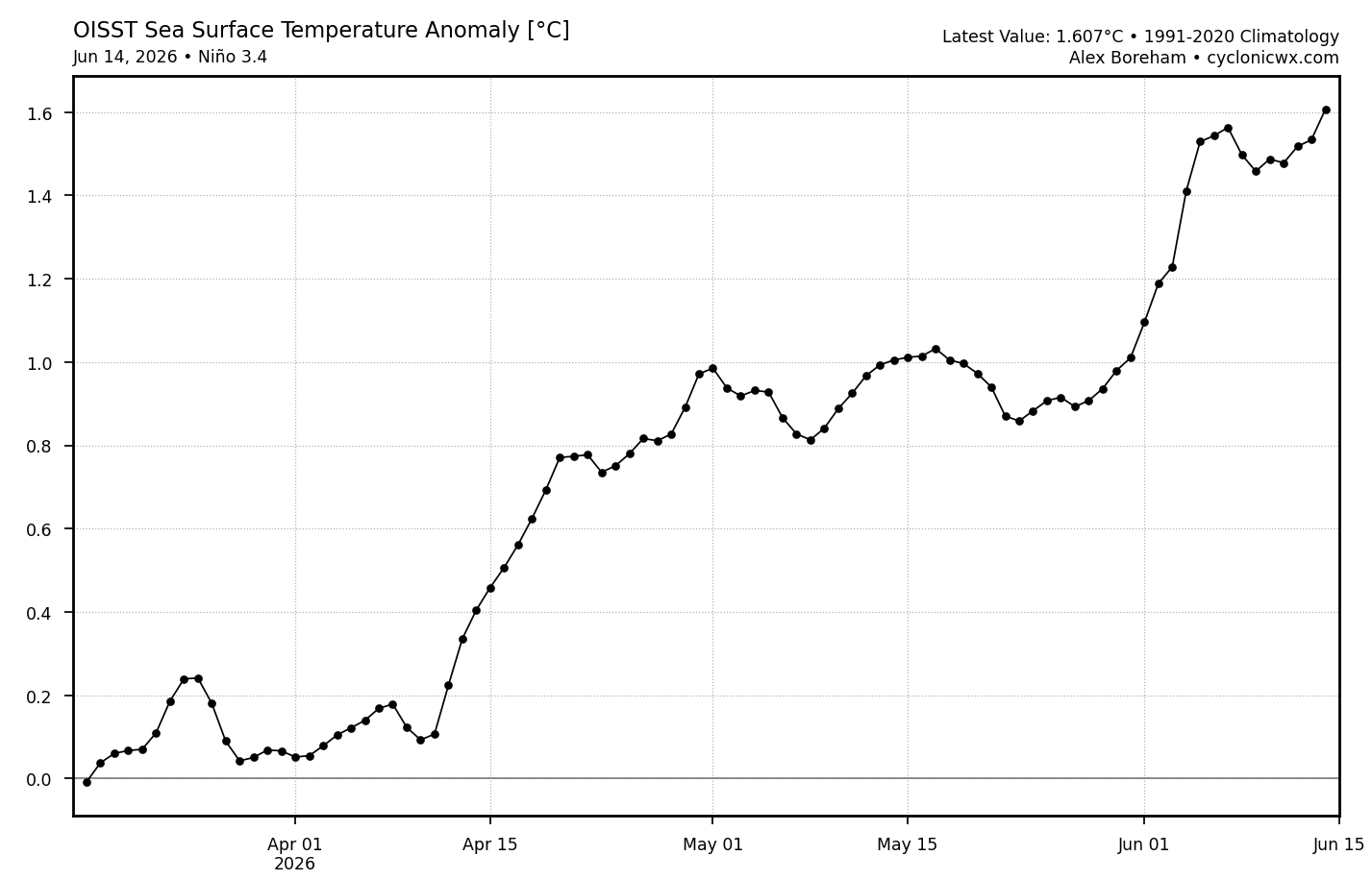
Impressive and record breaking Nino 3.4 lead over 2016 and 1997 for June 14th at 29.32C or +1.61 C.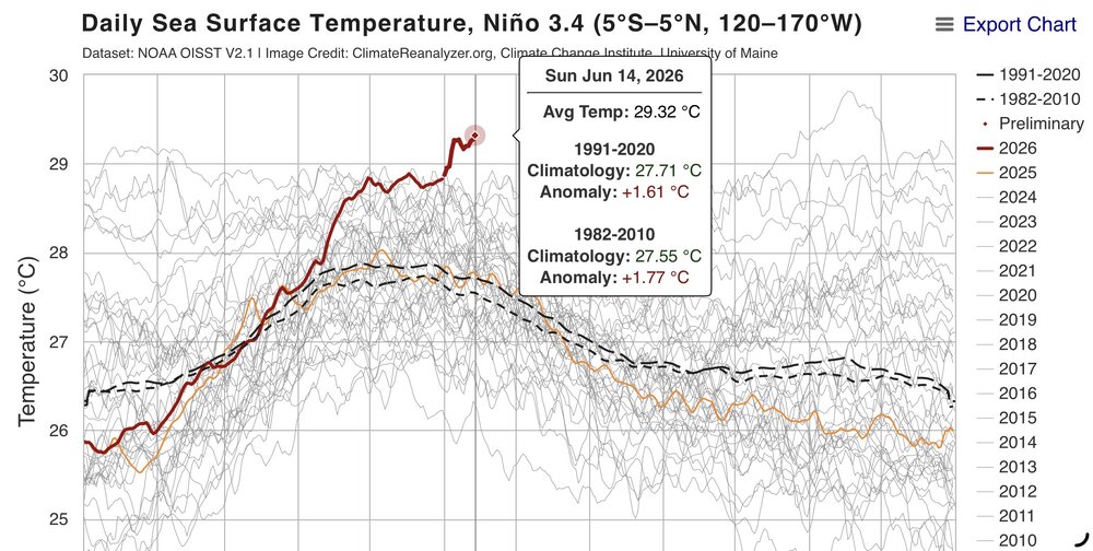


-

2026-2027 Super El Nino
GaWx replied to Stormchaserchuck1's topic in Weather Forecasting and Discussion
The latest OISST 3.4 1991-2020 anom of +1.607, which is for June 14th, is the warmest for this Nino to date and is ~0.075C warmer than that for June 13th making it the largest warming for any day since June 5th:
- Today
-
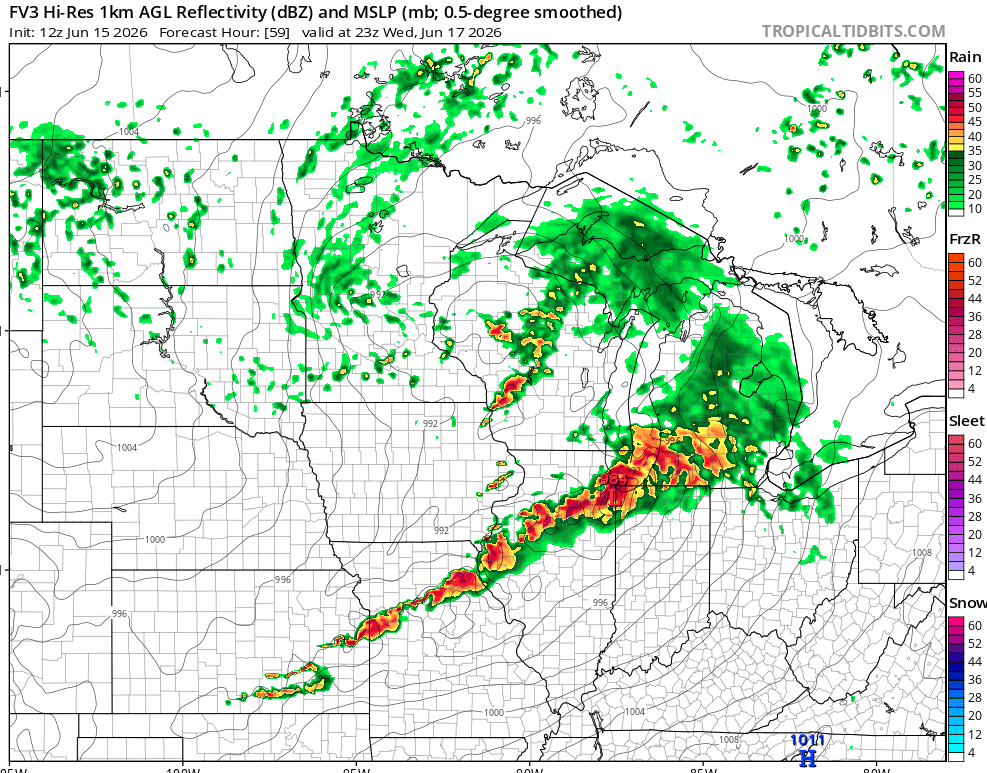
Looks like a classic Illinois day on Wednesday. Parameters are high, and that could all go into a windstorm, but I have to favor supercells initially. So far looks like morning rain will scoot out and leave a lovely outflow boundary with which to work. Factors that should get a big ol' bow echo going are WAA at 850 / 700 mb, 500 mb orientation / height falls, deepening sfc low, high instability, and an east-west boundary (outflow). That said, barring a quick mess, I'm thinking Illinois will book another tornado day. Models line up with the morning rain pattern recognition. In this case looks like it gets away in plenty of time to reheat. Outflow boundary OFB will locally enhance low-level shear. Some of the soundings are little skinny, but that may be a result of temperature forecast uncertainty. Should be skinny north of the OFB, probably fatter south of it. Both sides the LI is robust. Should get supercells along both the synoptic boundary and outflow. As usual we favor the boundary intersection. Also as usual, exact strategy will be a game time decision. Right on the intersection, or 1-2 cells east of it. Back on Thursday I believe the cyclical beast of the day was east of the main triple point, but on another differential heating boundary. Time will tell how Wednesday goes. From pattern recognition I infer initial tornadoes, perhaps 1-3 cyclical supercells. Then it will congeal into quite the bow echo.
-
According to this database (still seemingly updated), it would be record-breaking or nearly so for June once it gets into the lower GL region. Per the map below, record low pressure in June from Chicagoland into the central portion of the lower peninsula of michigan is ~992-993mb https://www.wpc.ncep.noaa.gov/research/roth/SLPrecords.html
-
2026-2027 Super El Nino
GaWx replied to Stormchaserchuck1's topic in Weather Forecasting and Discussion
I see only 1979+ in the table. Based on it, the 2026 rise from MA to AM of 0.9C (-0.6 to +0.3) is the biggest rise for MA to AM since at least 1979. The previous biggest was the 0.7C of 2015: https://psl.noaa.gov/enso/mei/ -
Perfect day out there-AC off and windows open. 74 here
-
Could be some great radiational cooling tonight into the upper 40s at usual radiational cooling spots.