All Activity
- Past hour
-
Something about this morning's weather feels like beach weather right now
-
-
The ECMWF site provides them. The most skill is week 1 followed by week2. But the 3rd week out and beyond are often very low skill. https://charts.ecmwf.int/?facets={"Product type"%3A[]%2C"Range"%3A["Sub-seasonal"]%2C"Parameters"%3A[]%2C"Type"%3A["Forecasts"]}
-
First week of June Dep Thru Jun 7th: EWR: +1.9 (0.57) JFK: +1.7 (0.33) NYC: +1.1 (0.72) LGA: +1.1 (.30)
-

2025 summer max contest -- enter by 06z June 23
RickinBaltimore replied to Roger Smith's topic in Mid Atlantic
DCA - 99 IAD - 98 BWI - 98 RIC - 99 -
Today and Monday will be cooler than the last few days with temperatures remaining 6 to 8 degrees below normal for June. Highs on both days will be not too far from 70 degrees with some higher ridge locations staying in the upper 60's. Shower chances are around today through Tuesday morning before we clear out and warm up by Wednesday. By Wednesday temperatures should return to near normal with highs near 80 degrees with temps rising to the mid 80's by the end of the new work week.
-
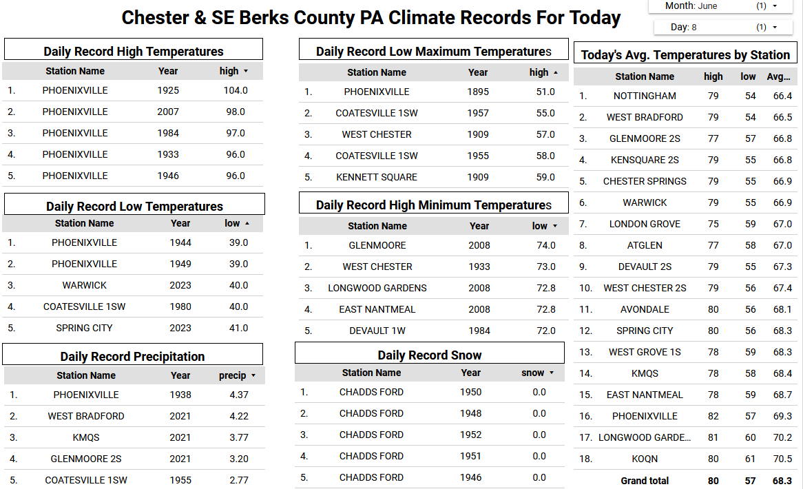
Records: Highs: EWR: 99 (2011) NYC: 95 (1933) LGA: 97 (2011) JFK: 96 (1999) Lows: EWR: 44 (1932) NYC: 47 (1932) LGA: 50 (1977) JFK: 50 (1997) Historical: 1885: A killing frost occurred at Fargo, ND. This date remains the latest on record. (Ref. Wilson Wx. History) 1920: Yosemite Valley, CA plunged to 14°; their coldest June temperature on record. (Ref. Wilson Wx. History) 1950: Two inches of snow fell at Billings, MT. This is their latest measurable snowfall on record. The high for the day was only 42°, a record low maximum. (Ref. Wilson Wx. History) 1951: A tornado was captured on motion pictures for the first time in the USA. 1953 - The worst tornado of record for the state of Michigan killed 116 persons. Flint MI was hardest hit. The tornado, half a mile in width, destroyed 200 homes on Coldwater Road killing entire families. (The Weather Channel) 1957: A tropical storm moved in from the Gulf of Mexico and crossed northwest Florida, spawning a tornado outbreak and flooding rainfall. Five people drown in the Gulf of Mexico when a small fishing vessel capsized in high seas. A shrimp boat was sunk off Ft. Myers, and several other boats were driven ashore south of Tampa. At least 9 Tornadoes were reported in Alachua, Marion, Clay, Putnam, and Duval counties (Jacksonville area). Tornadoes damaged roofs and uprooted trees. Heavy rains of up to 19" in 48 hours caused much local flooding and considerable agricultural damage, closed many roads and washed out several small bridges. Two hundred people were evacuated from flooded residential areas in Taylor County. (Ref. Wilson Wx. History) 1966 - A tornado ripped right through the heart of the capitol city of Topeka KS killing sixteen persons and causing 100 million dollars damage. The tornado, which struck during the evening, cut a swath of near total destruction eight miles long and four blocks wide. It was the most destructive tornado of record up until that time. (David Ludlum) 1974 - Severe thunderstorms spawned at least twenty-three tornadoes in Oklahoma during the afternoon and evening hours. One of the tornadoes struck the town Drumright killing sixteen persons and injuring 150 others. A tornado struck the National Weather Service office in Oklahoma City, and two tornadoes hit the city of Tulsa. Thunderstorms in Tulsa also produced as much as ten inches of rain. Total damage from the storms was around thirty million dollars. It was the worst natural disaster of record for Tulsa. (Storm Data) 1987 - Thunderstorms in the northeastern U.S. produced large hail and damaging winds in Vermont injuring two persons. Thunderstorms in Ohio produced wind gusts to 75 mph near Akron, and deluged Pittsfield with two inches of rain in thirty minutes. (The National Weather Summary) (Storm Data) 1988 - Overnight thunderstorms in Iowa produced 5.20 inches of rain at Coon Rapids. Thunderstorms in the Florida Keys drenched Tavernier with 7.16 inches of rain in 24 hours. Eleven cities in the central U.S. reported record high temperatures for the date. (The National Weather Summary) 1989 - Thunderstorms produced severe weather over the Central Gulf Coast Region during the day and evening. Severe thunderstorms spawned 17 tornadoes, including one which injured ten persons and caused a million dollars damage at Orange Beach, AL. Thunderstorm winds gusting to 90 mph killed three persons and injured four others at Mobile AL. Thunderstorms also deluged Walnut Hill and Avalon Beach, FL, with eight inches of rain. (Storm Data) (The National Weather Summary) 1993: An F2 tornado struck four farmsteads, damaging one severely, just southeast of Osage, IA. Two F0 tornadoes touched down in Olmsted County, MN in Dover and Pleasant Grove, three F0 tornadoes in Mower County, Minnesota in Dexter and just south of Leroy and Grand Meadow, and an F0 tornado touched down ten miles south of Spring Valley. On this same date, 18 other tornadoes touched down in Wisconsin. Prairie du Chien, WI had 3.22 inches of rain. (Ref. Wilson Wx. History) 1995: Classic supercell thunderstorms spawned 21 tornadoes in the north Texas Panhandle. 5 of the tornadoes were rated F4 on the Fujita scale, one which tracked through the center of Pampa injuring 7 people and causing $30 million in damages. The Project Vortex team (20 vehicles, including a state of the art truck-mounted Doppler Radar, and two P3 aircraft's) were all over the storms, collecting an incredible storm dynamics, structure, and environment data set, on the last day of the two year funded project no less. The team witnessed one of the F4 tornadoes near Allison, and said it was one of biggest and meanest appearing tornadoes they had ever seen. At Crane, TX, four inch diameter hail fell for 10 minutes. (Ref. Wilson Wx. History) 2001: Tropical Storm Allison hits Houston, Texas, for the second time in three days. Louisiana and southern Texas were inundated with rain. Baton Rouge received 18 inches over just a couple of days. Some portions of Texas racked up 36 inches by June 11.
-

E PA/NJ/DE Summer 2025 Obs/Discussion
ChescoWx replied to Hurricane Agnes's topic in Philadelphia Region
Today and Monday will be cooler than the last few days with temperatures remaining 6 to 8 degrees below normal for June. Highs on both days will be not too far from 70 degrees with some higher ridge locations staying in the upper 60's. Shower chances are around today through Tuesday morning before we clear out and warm up by Wednesday. By Wednesday temperatures should return to near normal with highs near 80 degrees with temps rising to the mid 80's by the end of the new work week.

-
E PA/NJ/DE Summer 2025 Obs/Discussion
ChescoWx replied to Hurricane Agnes's topic in Philadelphia Region
All that matters is that if the season ended today they would once again be in the postseason! Once there they need some luck and to get hot just like all teams still alive come October. Do I think they can win the World Series? Of course.....Do I believe they will win the World Series?? As a long time Phillies phan - of course not - Go Phillies!!! -
72 / 60 caught in the sunnier / clear part of the area. Pending on how long it can stay partly sunny or have period of sun could get to 80, otherwise mid 70s / upper 70s. Scattered showers storms, cloudier - coolest day tomorrow with most staying at or below 70 with period of showers and light scattered rain. Front lfts back north tuesday with more showers and generally cloudy. Warmer drier Wed - Fri mid / upper 80s with some of the hot spots getting to or another 90 (Thu). Next front timing is later Friday into Sat and the usual front takes its time clearing the area next weekend with showers/light rain , storms both Sat/Sun. Beyond there 6/16 overall warm / wet (fstorms,slow fronts) period heat from the west buliding and spreading east towards the 20ths and week of the 22nd to close June.
-
@bluewave Getting back to your point of repeating global weather patterns, if the summer/fall plays out this way, besides the continuation of the +AMO, we may see another *possible* central Atlantic “Nino” develop along with a “Modoki” La Niña, which have both become much more common over the last 10+ years:
-
Good morning DIT. Thank you for incentivizing my last few brain cells to charge and search. (Sadly without beer.) stay well. As always …..


-
https://www.ospo.noaa.gov/products/ocean/tropical/tcfp/basins.html?basin=al-48 Scroll down the page a bit (about 2/3rds of the way down) to the Tropical Atlantic section ETA - I corrected the link
-
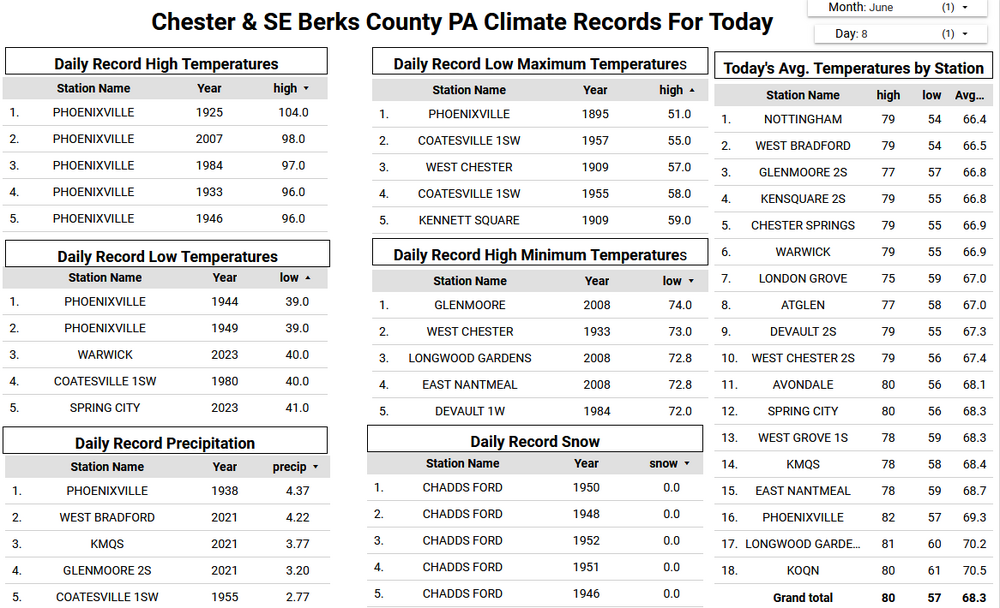
Please post the link for the vertical instability graphic. Thanks
-
1300z SPC OTLK continues mention of a few tornadoes ...Mid Atlantic Region... A shortwave trough currently over OH will track eastward today, with large-scale ascent overspreading the Mid-Atlantic states by afternoon. A moist surface air mass is present across much of VA/MD/NC and vicinity with dewpoints in the upper 60s. Persistent clouds and weak mid-level lapse rates will limit destabilization. However, it appears likely that storms will develop off the Blue Ridge by mid afternoon and spread eastward toward the coast. Forecast soundings show sufficient low and deep layer shear for supercell structures capable of damaging wind gusts and perhaps a few tornadoes.
- 945 replies
-
- 1
-

-
- severe
- thunderstorms
- (and 2 more)
-
If you’re talking about the biggest KU storms, I tend to agree. But there have been instances in recent winters where sub-KU storms have actually trended south in the last 24-72 hours. In the 2023-24 winter, my subforum (at least the central part) got 4-6” flush hits twice in the same week that trended to us the last minute after being modeled to go through PA/NY. This past winter, we’ve had a few happen the same way. Including one in late Feb that missed us and hit SE VA with a foot of snow, leaving us high and dry. So I guess it can cut both ways.
-
Close to an inch of rain here in 2 storms b/w 3:30 and 6pm. Cooler/drier today
-

Central PA Summer 2025
Mount Joy Snowman replied to Voyager's topic in Upstate New York/Pennsylvania
Low of 62 and .03” of rain. -
It seems our force field is back up. Back to the area between Richmond and DC getting swamped while everyone else gets scraps. The most lightning I've seen this year was from a thundersnow storm in January. It's been extremely boring this spring. I'd love to get a thunderstorm today.
-
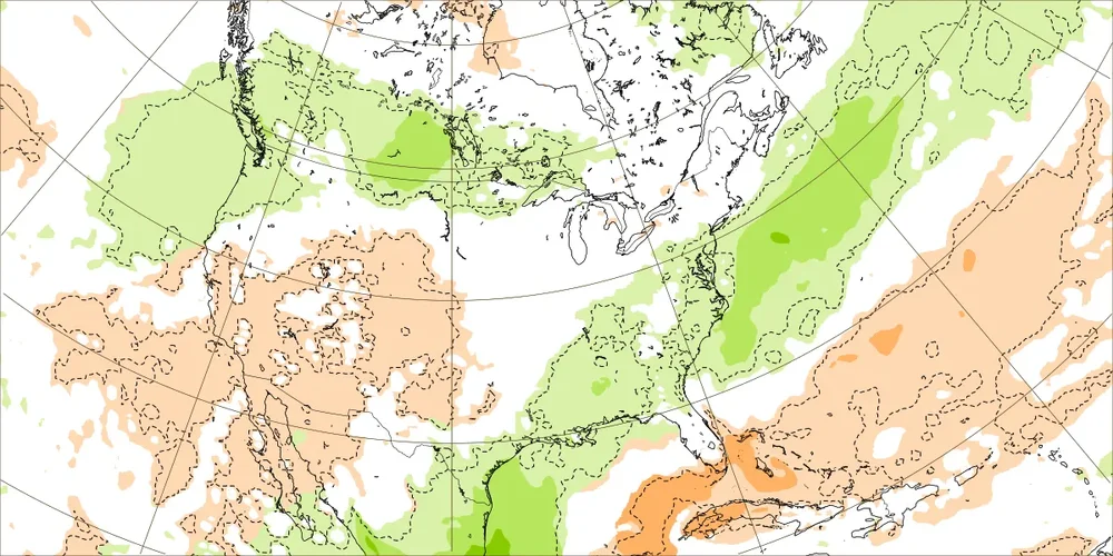
Can I have a link to these maps?
- Today
-
I'd be ok if the 14th and 15th are really wet. Who wants to mow on fathers day
-
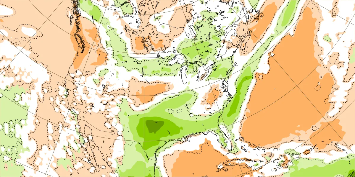
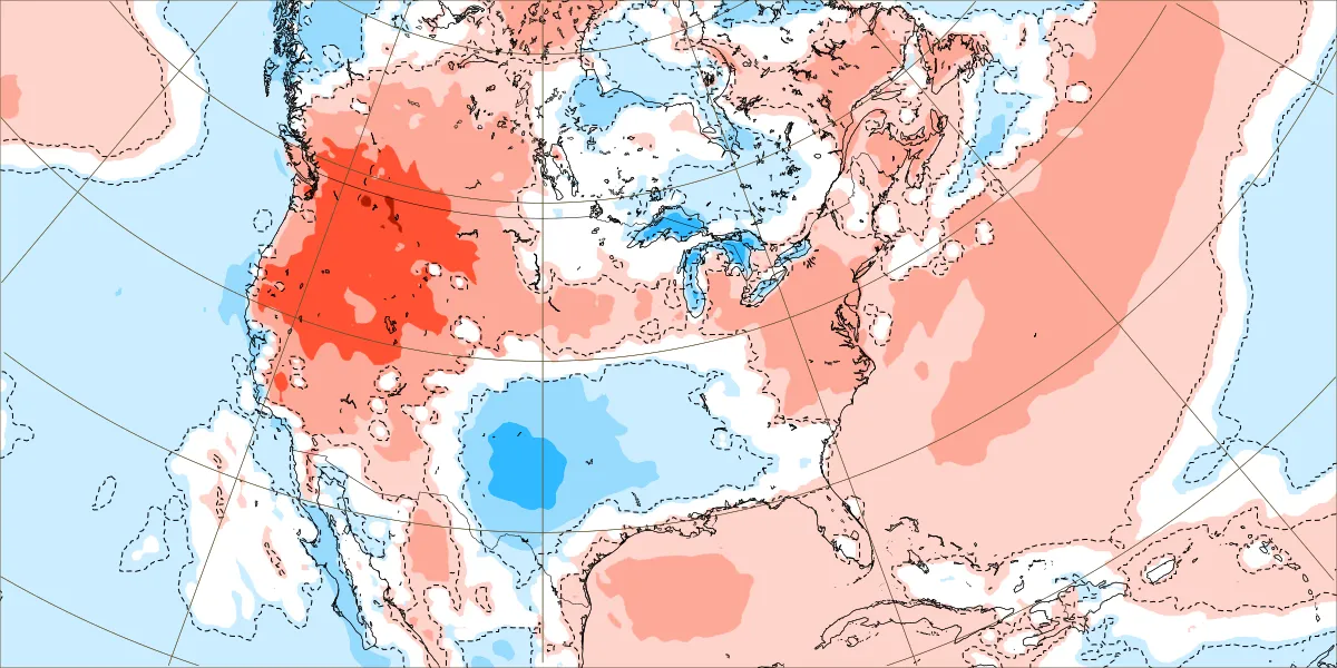
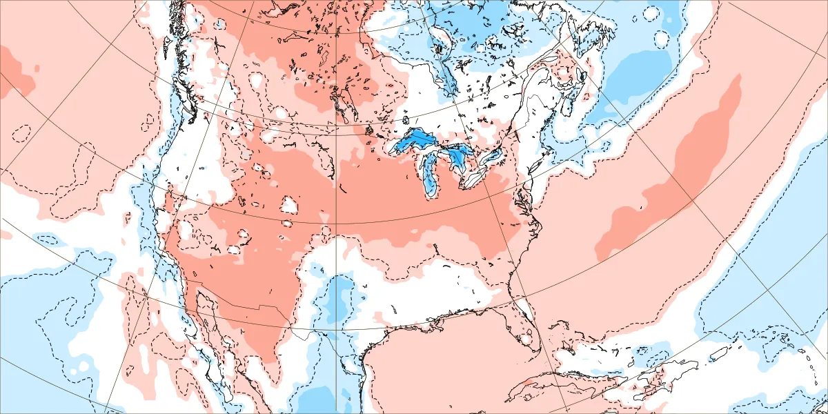
No major heat showing up for the next 15 days on the EPS. Wetter than normal with the warmest temperatures remaining out West. Plenty of onshore flow limiting the 90° potential. We’ll see if this can shift a bit after the solstice heading into July. June 9 to 16 rainfall and temperature departures June 16 to 23 rainfall and temperature departures


-
Beer this early?
-
Just saw a squirrel in the yard that had no tail. Looked like it was bitten off . Just a little stump. wtf
-
It’s all about the way model biases have been evolving over the years. We went many years near the I-95 corridor when the long range models weren’t snowy enough beyond a few days. Which is the complete opposite of the model error pattern since 2018-2019 with the record breaking Pacific Jet. The January 1978 KU snowstorm was originally forecast to be a rainstorm the day before and we got a surprise 15” snowstorm on Long Island. Then in February 1983 the original forecast a few days out was for the heaviest snows to stay down near Philly. But instead the heaviest snows shifted north into NYC Metro as the models got under 60 hours. The January 1987 KU event was forecast to be snow quickly changing to rain but instead we got a surprise 6-12”. The December 1988 surprise Norlun wasn't even forecast at all and we got a narrow 6-12” band. The January 1996 blizzard was originally forecast to get suppressed to the south of NYC from 120 hrs out. But came north in the models only 24 hrs out. The late January 2000 snowstorm was forecast to be OTS and delivered record snows in the Carolinas and over 6” around NYC. The record January 2016 snowstorm was only forecast to be 6-12” the day before around NYC and turned out to be 20-30”. So model errors in good snowfall seasons tended to be underdone beyond 24 to 48 hours out. What the models have been doing since 18-19 is showing heavy snows beyond 72 to 120 hrs only to correct further north with the heavy snowfall axis. So the error has been for the storm tracks to verify warmer and further north than originally forecast. This model error pattern worked for us with colder storm tracks to our Southeast which dominated before 18-19. Since the long range forecasts could still afford to shift north changing suppression to a KU. These days the storm track is already too far north so any shift north under 60 hrs gives us to more rain. So cutters, huggers, and suppressed Southern Stream storm tracks have lead to the record low snowfall from Philly to Boston last 7 years. The big snowstorm has always been beyond 120 hrs out. So this has become the dominant model forecast storm track bias. The one good thing about repeating model biases is that I use them in real time to correct the long range model forecast biases leading to better forecasts than the models.