All Activity
- Past hour
-
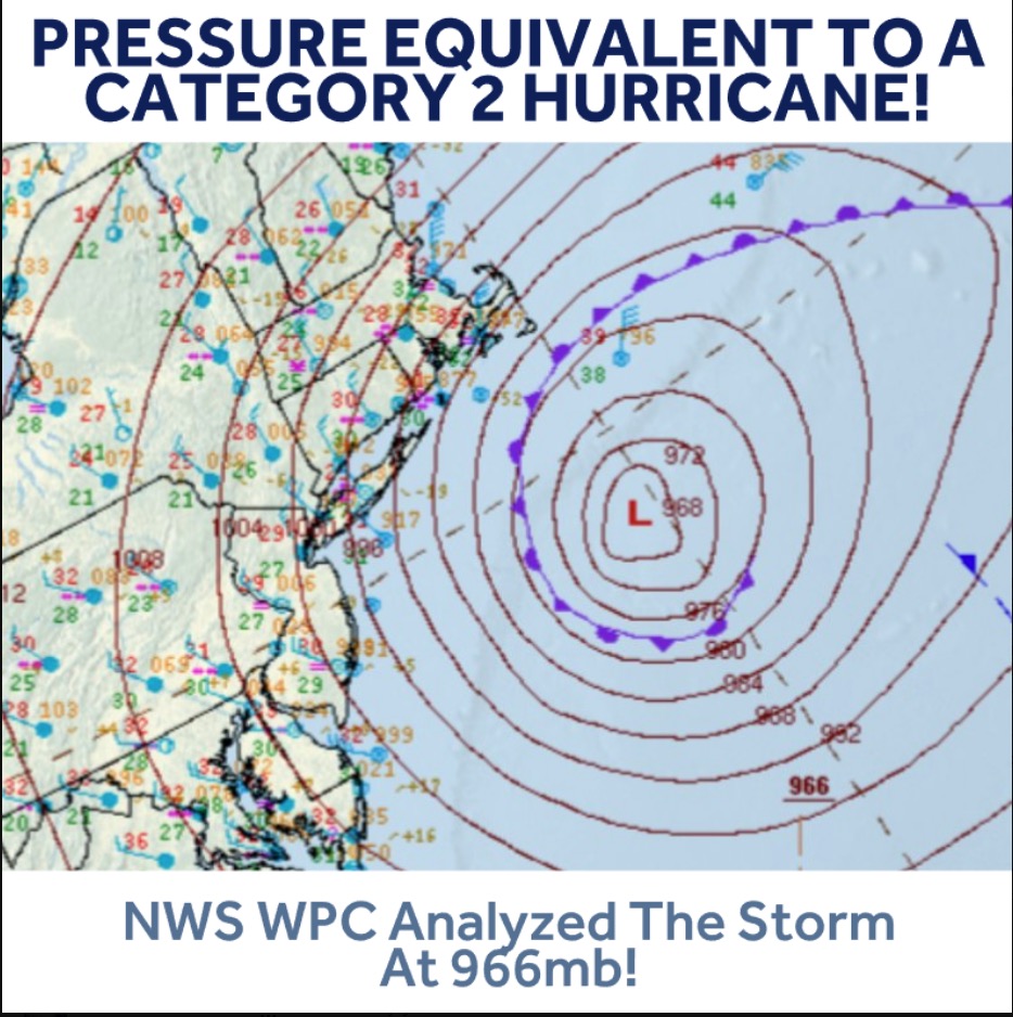
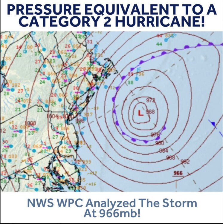
Analyzed lowest pressure was 966MB. Analyzed track was about 60 miles south of the BM. Full warm warm seclusion.
-
We should plot the grades on a map at the end of winter
-

"Don’t do it" 2026 Blizzard obs, updates and pictures.
40/70 Benchmark replied to Ginx snewx's topic in New England
Are you speaking of 700mb RH? Oh, surface...I see it. I always say shitty forecasts are the best learning tools...This is a perfect example of it. Class is session...I'll do better next blizzard. -
GFS makes the most sense - the Euro's don't .....
-

2025-2026 ENSO
Stormchaserchuck1 replied to 40/70 Benchmark's topic in Weather Forecasting and Discussion
So much for warm ENSO subsurface effecting pattern right now.. Feb-March La Nina state in Hadley Cell 2018-2026 has been incredible Bright sun in late Winter really correlating with +NPH (North Pacific High) -

"Don’t do it" 2026 Blizzard obs, updates and pictures.
Baroclinic Zone replied to Ginx snewx's topic in New England
Maybe a little slant sticked but not by much. Plenty of 36-37” reports in that area. -
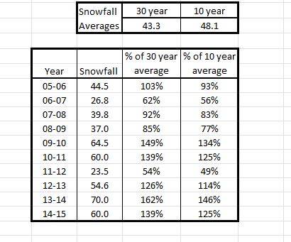
Solid A on a curve Snowy and cold, barely any r*** Good skiing and great skating Deep, deep pack Well AN snowfall already with more than a month to go
-
"Don’t do it" 2026 Blizzard obs, updates and pictures.
Baroclinic Zone replied to Ginx snewx's topic in New England
Yeah it did. -
Some frozen on EURO
-
2025-2026 ENSO
Stormchaserchuck1 replied to 40/70 Benchmark's topic in Weather Forecasting and Discussion
12z GEFS very warm March 7-11. DCA could make a run at 70s. -
I'm not usually a pack retention kind of guy, but it's been impressive this season. I've had 6 days since 12/3 with a T or less on the ground. And I've been over 10 inches on the ground since 1/26. Chuck in a normal March snowfall and I'll be at the best snow season since 2018-2019.
-

Late February/Early March 2026 Mid-Long Range
stormtracker replied to WxUSAF's topic in Mid Atlantic
I'm def more excited about this one than Sunday's storm. But for obvious reasons. What did the clown maps have? -
"Don’t do it" 2026 Blizzard obs, updates and pictures.
40/70 Benchmark replied to Ginx snewx's topic in New England
10" -

Winter 2025-26 Medium/Long Range Discussion
michsnowfreak replied to michsnowfreak's topic in Lakes/Ohio Valley
Some potential next Sunday-Monday timeframe. But keep the discussion in here. NO NEW THREADS -
I had to have got it from here:https://www.weather.gov/wrh/Climate?wfo=okx but like I said earlier, its gone now. You can still see snow for Port Jervis and West Point though if interested.
-
2025-2026 ENSO
40/70 Benchmark replied to 40/70 Benchmark's topic in Weather Forecasting and Discussion
Not what I said....however, SSTAs are less impactful when ENSO is weak...take a look at 1976...east based event, yet crushed NE. Even with Nina....2000 was modoki, yet crushed NE. (similar solar/QBO to this year). When ENSO is weak, other factors play more of a role, like solar cycle, etc. 18-19 was low solar-descending solar/west QBO, which is a shitty combo. 2019 was neutral. -
Gfs is more of a Monday afternoon into early Tuesday. Still a week out I’m sure in a couple days if it’s real we’ll see the timeframe… the way this years been wouldn’t be surprised to see it end up back on a Sunday Monday. Seems like most of our snow has been lol
-

Central PA Winter 25/26 Discussion and Obs
Itstrainingtime replied to MAG5035's topic in Upstate New York/Pennsylvania
It took 18" of snow/sleet together to keep a solid snow cover for a full week after 3/13/1993. If it wasn't for all of that sleet it would have been gone in 2-3 days. -
Winter 2025-26 Medium/Long Range Discussion
michsnowfreak replied to michsnowfreak's topic in Lakes/Ohio Valley
Since Jan 1st Detroit has only seen 1.77" precip (and 21.4" snow). Its much better than QC but its shockingly below avg for a La Nina. Fortunately its been nearly all snow except for a few meager lgt rain spurts. -

"Don’t do it" 2026 Blizzard obs, updates and pictures.
BombsAway1288 replied to Ginx snewx's topic in New England
Maybe because it looked like the pics were from a drift or just the total overall snow depth that had some on the ground before the blizzard? -

"Don’t do it" 2026 Blizzard obs, updates and pictures.
The 4 Seasons replied to Ginx snewx's topic in New England
what was your final i see 9 on that interactive map -
We know where this is headed…the same place it’s been headed all season….go with the muted warmth this year, and you’ll win. I’d be happy with some 50’s, and call it a warm up. And it won’t last either…
-
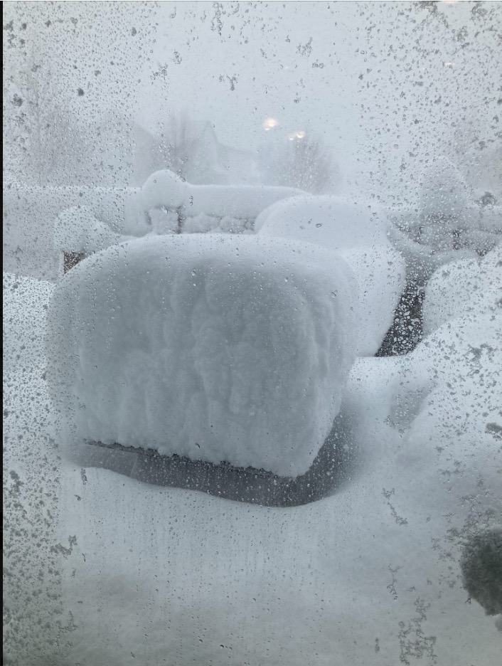
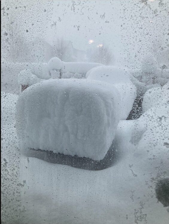
https://x.com/i/status/2026316284682760389 Drone video from yesterday along the coast of Massachusetts. Pretty impressive. Photo from Westerly R.I. late yesterday afternoon.
-
Is we back? February discussion thread
40/70 Benchmark replied to mahk_webstah's topic in New England
Agree. Big March incoming... -

"Don’t do it" 2026 Blizzard obs, updates and pictures.
HoarfrostHubb replied to Ginx snewx's topic in New England
Your neighborhood growing up took almost a week to get plowed in ‘78