All Activity
- Past hour
-
If the gfs is correct we could be having snow and ice while Kansas City is pushing 80. Blocking does such cool stuff. I hope it's real!
-

December 2025 regional war/obs/disco thread
weatherwiz replied to Torch Tiger's topic in New England
Still great to see this upcoming period continuing to hold potential. The late weekend period has my eye -
27 / 14 sunny. Progressing to an overall near / below normal once passed the warmup Christmas (Eve/Day) 12/24 - 12/26. Friday into Sat slop / flop or snow to rain. Warmth to the south / west and cold pushing down into the northeast. Next storm threat, beyond Friday/Sat is for the 30/31. Beyond there - near normal.
-
Bottomed out at 20 here. .
-
GFS is so far south it’s a miss.
-
21 here much colder than I expected
-
Scooter McGavin?

-
Fire Harbaugh to the sun, doo dah doo dah, fire Harbaugh to the sun, oh the doo dah day
-
Gefs have not been great with snowfall this year, and downright lousy at 96+ hrs. This threat may not workout for this forum, but that remains an accurate critique of the Gefs snowfall predictions this year.
-

White Christmas Miracle? December 23-24th
TauntonBlizzard2013 replied to Baroclinic Zone's topic in New England
Gfs is trying to clip eastern ma with the Norlun, similar to last storm -

Central PA Winter 25/26 Discussion and Obs
mahantango#1 replied to MAG5035's topic in Upstate New York/Pennsylvania
13 this morning. -
Where's your red tag?
-

December 2025 Short/Medium Range Forecast Thread
Holston_River_Rambler replied to John1122's topic in Tennessee Valley
Yeah, wild swings based on the placement and evolution. -
December 2025 regional war/obs/disco thread
TauntonBlizzard2013 replied to Torch Tiger's topic in New England
I’d love to lock in the 6z icon for Friday night. That would rip -
December 2025 regional war/obs/disco thread
TauntonBlizzard2013 replied to Torch Tiger's topic in New England
plenty of posts from northern New England at 12z yesterday congrats and high-fives over Friday/saturday storm. To be fair to everyone here, it is a holiday week, and the event has shifted so far south in rapid order that some runs are now whiffs. If that press continues to come in stronger it will be congrats Mid Atlantic. However, isn’t the old saying these bump north in the final 48? -

December 2025 regional war/obs/disco thread
Damage In Tolland replied to Torch Tiger's topic in New England
It was not -
December 2025 Short/Medium Range Forecast Thread
Holston_River_Rambler replied to John1122's topic in Tennessee Valley
I know it’s all fantasy but I think the 6z GFS was about to give us a new years present if it had run about an extra 36 hours. -

December 2025 Short/Medium Range Forecast Thread
Carvers Gap replied to John1122's topic in Tennessee Valley
If the cold air mass for Dec 28-Jan 1 verifies, ensembles across the board missed that cold air mass outside of day 7. To me it looks like another one is right after that(roughly Jan 6-7). As John noted, the late December cold snap looks like a dry frontal passage. I would guess higher elevations probably see some upslope if the CMC is correct. It would make sense that the atmosphere would wring out some moisture. One thing in weather, we are rarely going to get perfect placement of every feature on the map. What we want is the feature(which is in our favor) to be the driver. Outside of climatology Jan10-Feb10, it really doesn't want to snow at lower elevations in the Upper South. The base pattern is rain. So, we generally need a little bit of help outside of that window. As is, the pattern in the weeks 2-4 is likely going to have some cold shots, and some warmups. Timing and intensity of any longterm cold snap when/if it returns is TBD. That is why we are tracking what happens after the cold shot to end this year and begin the new one. My guess...models are handling the NAO poorly (duration, intensity, placement). That has occurred more times than I can count. As LC noted, it makes it difficult for models and forecasters to get a handle on things. That is creating wild swings in modeling. It does make sense that at some point, things line-up just enough to send a lot of cold air into the east at some point during January. But really, that is a pretty easy call - it is our coldest month! LOL. -

December 2025 regional war/obs/disco thread
Ginx snewx replied to Torch Tiger's topic in New England
I wake up every night for a bathroom trip. Keep the Euro loaded on the phone. Quick check then back to sleep. -
December 2025 regional war/obs/disco thread
TauntonBlizzard2013 replied to Torch Tiger's topic in New England
Negative -

December 2025 regional war/obs/disco thread
40/70 Benchmark replied to Torch Tiger's topic in New England
It's also into the holiday break period now, too....so folks may not be up at 6am. -
December 2025 regional war/obs/disco thread
40/70 Benchmark replied to Torch Tiger's topic in New England
Was probably Tbliz lol -
December 2025 regional war/obs/disco thread
Ginx snewx replied to Torch Tiger's topic in New England
WPC issued for 12Z for the 26th.png.d0f0e31af7e519028bba3ada8720bbb7.png)
-
(002).thumb.png.6e3d9d46bca5fe41aab7a74871dd8af8.png)
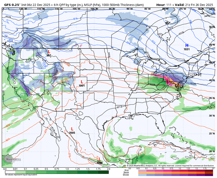
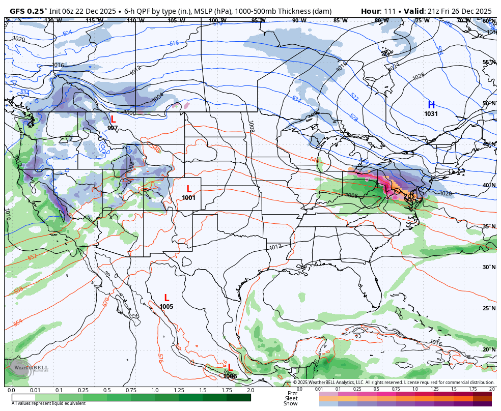
E PA/NJ/DE Winter 2025-26 Obs/Discussion
ChescoWx replied to LVblizzard's topic in Philadelphia Region
06z GFS -

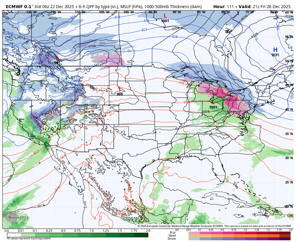
Central PA Winter 25/26 Discussion and Obs
Blizzard of 93 replied to MAG5035's topic in Upstate New York/Pennsylvania
If the trends from 0z & 6z on the Euro & GFS continue today, the forecasts for Friday will be changing rapidly. The 6z GFS has a snowstorm for southern PA & the 6z Euro shows an ice storm chance. The High is in a great spot, so let’s see how the trends go today.